
-
 27679 Hits
-
 95.49% Score
-
 53 Votes
|
|
Area/Range |
|---|---|
|
|
38.27269°N / 109.99512°W |
|
|
Hiking, Trad Climbing, Scrambling, Canyoneering |
|
|
Spring, Summer, Fall, Winter |
|
|
5000 ft / 1524 m |
|
|
Preamble
One of the largest national parks in the United States, Canyonlands also contains some of the most remote terrain protected by any national park.Rivers carving sheer-walled canyons. Obscure peaks. Massive sandstone walls and pinnacles. Vistas of snowy mountains in the distance. Arches. Native American rock art.
It's all out there. And more. From hiking to rock climbing to river running to backcountry driving and mountain biking, there's something out here for just about any outdoor enthusiast.
Note-- the person who had created a page for the Needles District has deleted that page. If you feel qualified to remake it, please do so and make this page complete again!
History
 Horseshoe Canyon scene-- by thephotohiker
Canyonlands National Park, located near Moab, Utah and the Arches National Park, was designated as a National Park on September 12, 1964. The park protects some of the wildest and most remote desert country in the United States, and the vast expanses and rugged terrain provide both challenges and rewards for the adventurous. Few other places in the country feel so removed from the "civilized" world.
Canyons carved into the Colorado Plateau by the Colorado River and Green River partition the area into three major districts:
-Island in the Sky to the north
-The Needles to the southeast
-The Maze to the west
Geography
The Island in the Sky and Needles districts are accessible via paved roads from U.S. 191, which passes through Moab. The Maze is the most remote of the three districts and is only accessible from the west (Utah 24 or 95) via unpaved roads. There are no road connections between the districts within the park, and traveling between them may take two to six hours by car. Classic view from Island in the Sky-- by njn8734
Island in the Sky is a broad and level mesa to the north of the park between the Colorado and Green Rivers, with many spectacular overlooks over the White Rim, a sandstone bench 1200 feet (365 m) below the Island, and the rivers, which are another 1000 feet (304 m) below the White Rim.
 Monument Basin, Island in the Sky
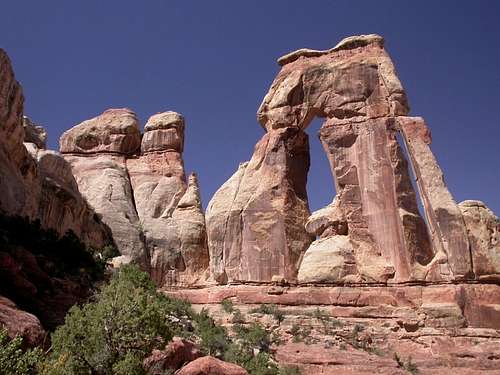
The Needles District is named after the red-and-white-banded rock pinnacles which dominate it, but various other forms of naturally sculptured rock like canyons, grabens, potholes, and a number of arches similar to the ones of nearby Arches National Park can be found as well. Unlike Arches National Park, however, where many arches are accessible by short to moderate hikes or even by car, most of the arches in the Needles District lie in backcountry canyons and take long hikes or four-wheel-drive trips to reach.
This area was once home of the Ancestral Puebloan Indians, of which many traces can be found. Although the items and tools they used have been largely taken away by looters, many of their stone and mud dwellings are well-preserved. The Ancestral Puebloans also left traces in the form of petroglyphs, most notably on Newspaper Rock, which is outside the park but along the drive to the Needles entrance station.
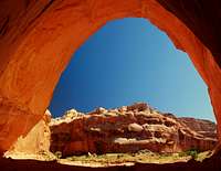
 Druid Arch, Needles District-- by rpl001
The Maze District, west of the Colorado and Green Rivers, is the most remote and inaccessible section.
The small detached section to the west, the Horseshoe Canyon unit, contains large panels of rock art made by hunter-gatherers who predated the Ancestral Puebloans. The most notable panel in the canyon is named the Great Gallery.
 Great Gallery, Horseshoe Canyon
Getting There
Canyonlands National Park is located in southeastern Utah, approximately 30 miles southwest of the town of Moab. There are two paved entrances into Canyonlands: Highway 313 leads to the Island in the Sky District and is 10 miles north of Moab; Highway 211 leads to the Needles District and is 40 miles south of Moab. Roads to the Maze District are a mixture of graded dirt and 4WD roads that may become impassable when wet.Red Tape and Weather
Persons wishing to go into Canyonlands must realize that cell phone service may be nonexistent at times and a GPS will definitely come in handy if you are lost or if you or one in your party becomes injured. Remember, you are essentially in the "middle of nowhere." Leave detailed info on where you're going in the park with someone you know or at the ranger station; due to the expansiveness of Canyonlands National Park, search-and-rescue may take days to find you if you go off-trail.As a side note, it has been stated by some newspapers and people in the area that certain individuals who do not wish to be found find refuge in Canyonlands. Take precautions.
Weather can sometimes come upon you rather quickly here, torrential downpours are not uncommon. Be prepared for flash floods, fast-moving storms, and wild lightning.
Summers can be uncomfortably and even dangerously hot. Winters can be bitterly cold, with snowstorms. Spring and fall are the best times to be here.
Camping
There are developed campgrounds in the Island in the Sky and Needles Districts. Reservations are not accepted.Primitive camping is available at many trail and 4WD road sites throughout the park. It is wise to reserve a permit well in advance.