
-
 45597 Hits
-
 89.68% Score
-
 30 Votes
|
|
Area/Range |
|---|---|
|
|
44.50407°N / 123.55182°W |
|
|
Hiking, Mountaineering, Scrambling |
|
|
Spring, Summer, Fall, Winter |
|
|
4097 ft / 1249 m |
|
|
Overview

The Oregon Coast Range is an ancient volcanic island chain that collided with North America 50 million years ago. It runs north/south at an average of about 20 miles inland from the Pacific Ocean all the way from the Columbia River on the northern border of Oregon about 3/4 of the way south in Oregon to where it meets the Siskiyou Range of the Klamath Mountains. (Well, it is not that nice and neat. There are some low hills north of the Oregon border in Washington but they peter out quickly before the flatlands south of the Olympic Mountains. Some websites include Oregon's southern Coastal Ranges of the Siskiyous/Klamath Mountains as the "Coast Range" but it is widely felt those are separate ranges and won't be included on this page. Click here to see a topo map of Oregon which shows where the "busier" Siskiyous collide with the lower Coast Range.)
The majority of the range lies within the Siuslaw National Forest which encompasses over 630,000 acres and runs from Tillamook to Coos Bay along the Oregon Coast from the Pacific Ocean to the Willamette Valley. It is one of two national forests in the lower 48 to have oceanfront property.

The peaks range in height from about 1000 to the high point of 4097 feet at Marys Peak near Corvallis, OR. Most mountains are in the 2000-3500 range though. The ancient volcanoes do extend right to the ocean and form cliffs of almost 1000 feet on many of the headlands. The range is heavily logged with the dominant species being Douglas fir, western hemlock and western red cedar with some Sitka spruce along the coast (including the tallest one in the US).
The western slopes capture most of Oregon's famous or infamous rainfall exceeding 150 inches annually (up to as much as 200"). This range is also heavily logged with big rectangles of clearcut throughout. The copious precipitation also provides lush pastures which accounts for the heavy dairy industry presence here. Click here to see the typical Oregon cloud pattern.
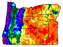
Oregon Precipitation Zone map courtesy of Oregon Climate Service
Probably due to the low elevations, there are but a few submissions from this range on summitpost. Those submissions are only the well-known ones with long-established trails (so keep submitting more SP'ers!). Up north, near Seaside, is Saddle Mountain one of the higher peaks in the northern section. It's a popular one and a county highpoint as well. Near Manzanita on the coast is Neahkahnie Mountain with two trails and great views of the ocean and beaches. Between Saddle and Neahkahnie, lies Onion Peak. In between Tillamook and Banks, smack dab in the middle of the northern section, are Kings Mountain and Elk Mountain, which can be combined in a great loop hike with decent mileage and elevation gain. Also nearby is the highest peak in the northern Oregon Coast Range, Rogers Peak. Further south in the middle of the state is the highest point in Oregon's Coast Range, Marys Peak as well as nearby Grass Mountain. Way down south is Humbug Mountain.
Noteable peaks absent from summitpost in the Coast Range are Laurel Mountain Oregon's rainiest place and Mt. Hebo with its array of military towers. Here's a link to some others.
Travel/Getting There/Conditions
Road Conditions
Roads running to/through the Coast Range
Please consult the specific mountain pages for detailed directions to the various individual peaks and their trailheads.
Be careful on roads that bisect the range especially in the winter. Rain and ice and very windy roads make travel hazardous in all but the sunniest conditions. Road closures occur on a lot of the smaller roads and people have been trapped and died in their vehicles. If you are traveling in winter, take chains or use snow tires and bring enough emergency supplies for several days in case you are stuck.
A recent example of what you don't want to happen.
Siuslaw National Forest Contact Information
Other Hazards

While the Coast Range is not very big or tall compared to other ranges out West, nevertheless, there are some dangers to be aware of and to avoid. The area is populated with black bear and cougar and attacks could happen. There can also be copious amounts of insects/pests such as mosquitos and ticks. And always remember, even the well-known and well-traveled trails can be deadly, even to SP members. Finally, be very aware of road closures and winter conditions. Some roads are not plowed or patrolled during certain times of the year which has led to tragedy.

Current Weather

North Boundary
---------------
North-Central Area
-------------------
Central
--------
South/Central Coast
--------------------
South Boundary
---------------
Tourist and Other Links
Central Oregon CoastCape Perpetua Scenic Area
Oregon Coast Aquarium
Native Americans of the Oregon Coast
Recreational Destinations
Sea Lion Caves
Books
Sullivan's 100 Hikes Oregon Coast and Coast RangeOregon's Coast Range and Siskiyous