
|
|
Mountain/Rock |
|---|---|
|
|
0.41473°N / 29.93774°E |
|
|
Mountaineering |
|
|
Summer |
|
|
16762 ft / 5109 m |
|
|
Overview
Mount Stanley is the highest massif in the Rwenzori (also spelled Ruwenzori) Mountains on the Uganda/Democratic Republic of the Congo border. It is a spectacular mountain rising through jungle and otherworldly bogs, culminating in a number of sharp peaks surrounded by one of Africa’s largest concentration of glaciers. These peaks include:
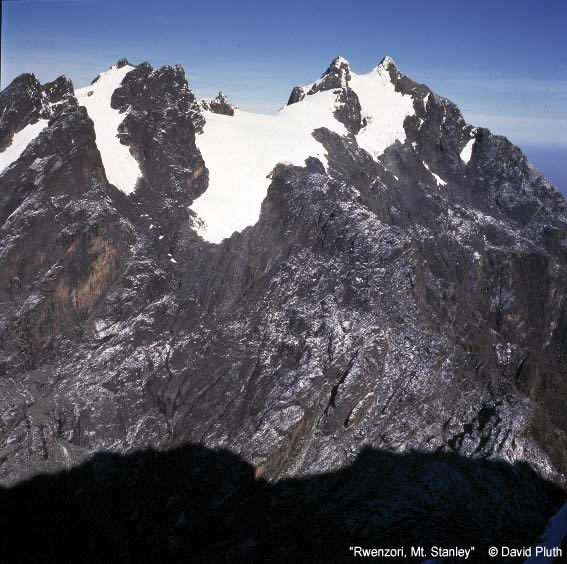
Margherita Pk.5109 meters The rightmost summit, Alexandra immediately left.
Alexandra Pk. 5091 meters from Margherita Summit
Albert Pk. 5087 meters
Savoia Pk. 4977 meters Highest Summit to the left.
Elena Pk.4970 meters
Elizabeth Pk.4928 meters
Philip Pk. 4919 meters
Moebius4918 meters
Kitasamba4860 meters
Nyabubuya4860 meters
History:
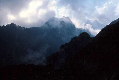
Mt. Stanley seen from the slopes of Mt. Baker.
As early as the time of the Ancient Greeks, there were tales of mountains of snow and ice forming the source of the Nile River. Aeschylus talked of "Egypt nurtured by snows" and Arstotle noted 'Mountains of Silver, the source of the Nile' in the fourth century B.C. Ptolemy labeled these mountains in the correct location as “Lunae Montes” (The Mountains of the Moon) in his map published some 1800 years ago. According to the expedition account of the Duke of Abruzzi, this was actually a translation error from the name “white mountains”, but the name has stuck through the millennia.
Despite the legends, the existence of these mountains was not confirmed outside of Central Africa until the arrival of Henry Morton Stanley. In 1876 he first glimpsed the range, then in 1888 he noticed what he first thought to be a cloud then later realized was the slopes of a mountain covered with snow.
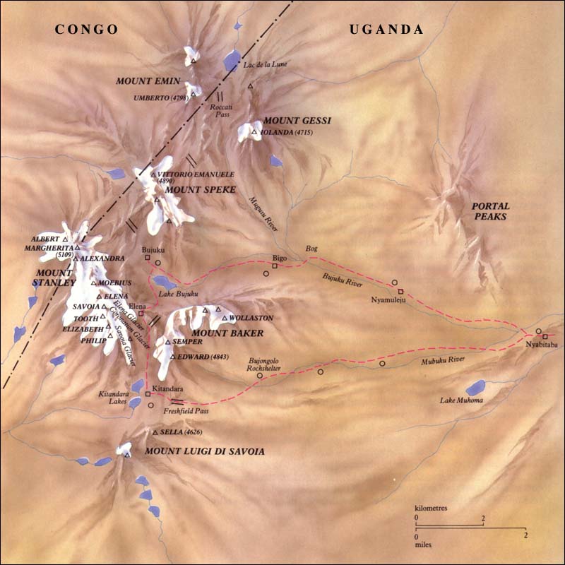
For a number of years explorers attempted to reach the peaks but were always turned back by the thick vegetation, bad weather, disease, or lack of time. However, in 1906, the Duke of Abruzzi led an expedition replete with six scientists, four alpine guides and the phenomenal photographer Vittorio Sella. With the help of over 300 porters, they climbed to the highest points of the six massifs in the range that at that time contained glaciers, including the highest peaks of Mt. Standley. Click here for a nice map of the range. The ascent of Margherita Peak was made by the Duke, J. Petigax, C. Ollier and J. Brocherel on a traverse from the summit of Alexandra Peak.
Sadly in the intervening years the area has been plagued by political instability, warfare and dictators and malaria. As recently as 2003, there were reports of AK-47 toting cannibals roaming through the town of Bunia across the rift valley from the range in the Democratic Republic of the Congo. Additionally, the once magnificent glaciers have retreated profoundly. Three massifs have lost their ice entirely. Mt. Baker only has a few minor remnant glaciers, and Mt. Speke a single remaining glacier of any consequence. Mt. Stanley is currently the only peak in the range that still contains extensive glaciation. Recent studies indicate that the ice may be entirely gone by the year 2025. Click here , on this site, and here for information.
Geology/Climate

Groundsel Forest, Rwenzori Mountains
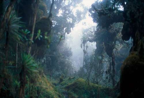
Mt. Stanley is a fault block mountain rising between two rifts in the African Rift System. They were formed within the past 10 million years and contain gneiss and quartzite. The mountains are nearly perpetually covered in mists, rains with frequent thunder and lightning. Nowhere else in the world is there such an astonishing collection of bog, moss, and forests looking more like those from the Lord of the Rings than Earth. Most of the year, heavy rain, sleet and snow lash the range, but the two drier spells are January/February and mid June through mid August. It is highly recommended that you plan your trip for one of those time periods. Even then, there can be weeks of constant fog and shower. I was in the range for 14 days and experienced only one day without precipitation, although there was thunder on that day as well. Frequently, though, the rains were light and only for a short portion of the day.
Getting There
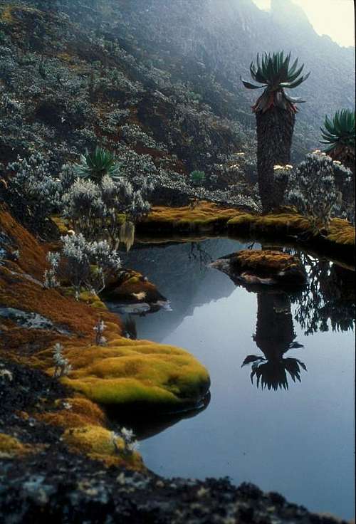
Small pool near Freshfield Pass.
Currently, the most reasonable access to Mt. Stanley is from Uganda. The Entebbe Airport, on the shores of Lake Victoria, is excellent with frequent connections to Nairobi. There are many hotels available in Entebbe or in Kampala only about half an hour to the north. From Kampala, there are two major routes to the mountain: a northern one through the beautiful town of Fort Portal, then south to Ibanda, and a southern route through Kasese that crosses the equator twice. Each of these takes the better part of a day to reach Ibanda at the foot of the mountains. The roads on the northern route vary from excellent to rough dirt tracks, while those on the southern route are generally good paved surfaces. Sadly when I visited, there was the constant smell of burning forests on the northern route as the once extensive forests are converted by slash and burn agriculture.
I have heard that public transportation from Kampala to the Rwenzori, although cheap, is rather difficult to take advantage of. When I went, I hired a local outfitter (Churchill Safaris) to take care of the logistics, and was driven to the mountains in an air conditioned four wheel drive vehicle.
Red Tape

Giant Groundsel
I don't have any first hand knowledge about entry into the range from the Democratic Republic of the Congo. Although the area has calmed down somewhat recently, the world's worst conflict since World War II still lingers there. There are recent reports of rebels within the Parc National des Virunga, and more than 210 park rangers have been murdered there over the course of the past decade. Although the majority of the park is close to the Rwanda border, and you may be taking a risk, Virunga National Park reports that it is possible to access the range at this point. There is a fee of USD 200 as well as an additional fee of USD 116 to sleep in the huts. Flights can be arranged from Goma, or access might be gained from the Mpondwe/Kasindi border. In terms of food, gear, and working out wages to pay porters, you are on your own... This conflict has been documented extensively on the internet but largely ignored internationally. For background on the D.R.C. click here, for further information including travel warnings, passports and visa requirements click here.
Uganda has had its own political instability. Until the past year or two there were frequent reports of horrible events in the northern part of the country. During 2006 and 2007 things seemed to settle down somewhat as a tentative cease fire was reached. Current information on Uganda can be read here. Further information including travel warnings, passport and visa requirements can be accessed here.
As noted above, the Rwenzori Mountains are a U.N. Heritage Site and are protected as National Park on both sides of the border. Visitors to the park are to be accompanied by a guide and porters. When I was there in 2004 I also had the escort of a park ranger carrying an AK-47 to protect me against the elephants. I would surmise that he was also armed as a deterrent against Congolese rebels, but he stated that this was not a current concern. Climbing in the Rwenzori is administered by the Uganda Wildlife Authority and the Rwenzori Mountaineering Services. Currently, the fee for a week long trip into the range including an ascent of Margherita Peak is US $990, with a US $150 charge for each additional peak on Mt. Stanley. There are additional fees if you wish to ascend other mountains in the range. These are spelled out at: Travel Uganda
As of May 4, 2010, it was reported that the standard route on Margharita Peak is closed because a large crevasse opened up blocking the route. Thank you to Alpinist for posting this info! Check out a source here. My understanding is that a new way has been established to climb the peak at this point as of the fall of 2010, although I do not have firm evidence for that...
The guides and porters were extremely friendly and helpful, as were the Ugandan people in general. The overall tone among Ugandans that I came in contact with was one of optimism and good natured banter. The presence of the guides and porters on the trip made the experience much fuller than if they had been absent. I also had a cook who prepared outstanding food during the trip. I would highly recommend this as it is nice to come back to a delicious dinner after a day of hiking in the range's mists, sleet and snow.
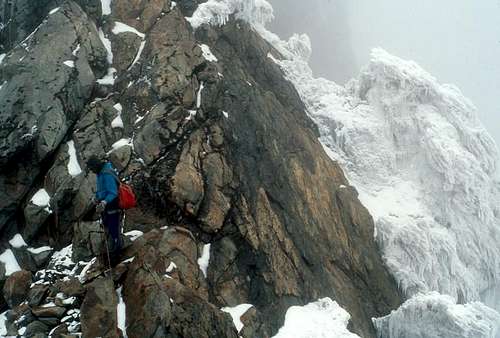 Climbing the South East Ridge of Alexandra Peak
Camping/Approach

Ferns, Bujuku Valley

Heather forest

Approaching the summit of Margherita Peak

Lobelia at the shores of Kitandara Lake.

Jungle near Mubuku River.

Lower Bigo Bog

View from Bujuku Hut

Lobelia on the shores of the Lower Kitandara Lake.
Traditionally, activity in the Rwenzori has been concentrated in a loop leading up the Bujuku valley, over the Scott Elliot Pass to the stunning Kitandara Lakes then over Freshfield Pass into the Mubuku Valley. There is a map at the website of :Great Lakes Safaris. There is an excellent system of huts and trails along this main circuit. The trails are very rough and contain deep mud in many places. At various times efforts have been made to install boardwalks over some of the deeper bogs but many of these have rotted and are currently in various states of disrepair. It takes most people roughly a week to approach and climb Mt. Standley. The following gives an idea of the itinerary that many people travel:
Day 1: Leave Ibanda, travel up the road to the Nyakalengija gate. From here one follows the Mubuku River for a ways through lush jungle, then across thickets hiding elephants and cobras to the start of a steep glacial moraine. This is climbed up past enormous ferns to the Nyabitaba hut at 2600 m where chimpanzees and monkeys may be heard or seen. Most people take about 5 hours to hike up a gain of 1200 meters. The hut has a spectacular view of the Portal Peaks.
Day 2: Descend down from the moraine to cross the Mubuku River, then a phenomenal hike through bamboo and trees coated with moss and ferns to the John Matte Hut at 3500 m. Sections of the trail on this day are extremely rough. Pictures posted by Mirek in 2007 show the bridge over the Mubuku River listing severely. 915 meters gained in 7 hours of hiking for many people.
Day 3: From the John Matte hut one crosses the Lower Bigo Bog to the older Bigo hut. At this point, it is possible to make a side trip (one or many days) up the Mugusu Valley to the Lac de la Lune, Ptolomy’s source for the Nile. This valley also provides access for Mt. Gessi and Mt. Emin. If one stays on the main circuit, they continue through spectacular vegetation past the Upper Bigo Bog and Lake Bujuku to the Bujuku Hut at 4075 meters. This takes many people 5 hours to ascend the 560 meters. If the weather is good, there are good views of Mt. Stanley from here. The Bujuku Hut serves as the usual base to climb Mt. Speke. Some fast hikers do the approach and peak ascent on the same day.
Day 4: Ascent to the Elena Hut, which once was beside the Elena Glacier at 4540 meters. It takes several hours to make the steep ascent. One portion of the climb is actually up a prolonged ladder (Groundsel Gully). The top portion of the climb is on steep moss covered slabs. The view from the hut is usually of fog but can be spectacular if the weather clears with the Portal Peaks and Mt. Baker prominent, as well as an impressive view of the Coronation Glacier on Mt. Standley. In many ways the crux of the climbing can be navigating ice coated ledges from the hut to the outhouse in the middle of the night.
Day 5: Ascent up steep often wet/verglassed slabs to the Elena Glacier and the Stanley Plateau, Africa's largest icefield. There are several possible lines that are used depending upon the conditions. From here, one has good access to the excellent SE ridge of Alexandra Peak. One can also cross the Stanley Plateau to the north reaching the tow of Alexandra's SE Ridge, drop down a steep gully to the Margherita Glacier, ascend this to the Alexandra/Margherita Col then from here ascend to the summit of Margherita Peak on snow trending left somewhat, then generally wet or icy rock. The Margherita glacier is heavily crevassed, many of which are covered by a thin layer of snow. In addtion, there are often wild ice formations along the way and on the adjacent ridges. At the summit, be sure to step to the West of the sign to enter the Democratic Republic of the Congo. It is also possible to continue along the ridge to the west to reach Albert Peak. Descend back to the Elena hut then continue down to the beautiful Kitandara Lakes. There is a large area out of site down the valley from here where all of the vegetation was denuded. When I asked the guide why he said that during the war (1996 – 2001 or so) there were planes then he made a motion of the plane dropping an incendiary bomb.
Day 6: Climb over Freshfield Pass (300 meters elevation gain) then descend to the Guy Yeoman Hut (3500 m). From near the pass it is possible to climb Mt. Baker or Mt. Liugi Di Savoia. The vegetation is phenomenal. On the descent, you pass by an old campsite of the Duke of Abruzzi (Bujongolo) where there is graffiti from expeditions from the early part of the 20th century.
Day 7: Exit to the Nyabitaba Hut then on out to the road. Of these forests, the Duke of Abruzzi wrote (1908):
“In this forest trunks and boughs are entirely smothered in a thick layer of moss which hang like waving beards from every span, cushion and engorge every knot, curl and swell around each twig, deform every outline and obliterate every feature ‘til the trees are a mere mass of grotesque contortions, monstrous tumefactions of discolored, leprous growth.
“No forest can be grimmer and stranger than this. The vegetation seems primeval, of some period when forms were uncertain and provisory. The silence is profound, and the absence of any sign of life completes the image of a remote age before the beginning of animal existence.”
Truly a spot as magnificent in its own way as any on earth.
This Main Circuit is operated by Rwenzori Mountaineering Service. Recent Trip Reports have expressed concern about the experience of some of the guides and the organization of the RMS when conducting an expedition.
Another possible approach is by the Kilembe Route. It begins in the town of Kilembe, and approaches the main peaks from the south-east, joining up with the Central Circuit near the Kitandara Lakes. This route can be used to climb Mt. Stanley in approximately eight or nine days.
This route is operated by Rwenzori Trekking Services. SummitPost member Tijs recently took this route and speaks highly of it and the service provided by Rwenzori Trekking Services. He notes that, unfortunately, people cannot take the Kilembe Route into the mountains and the Central Circuit out due to the fact that there are different tour operators for the two routes.
For a map of this route, go here.
External Links
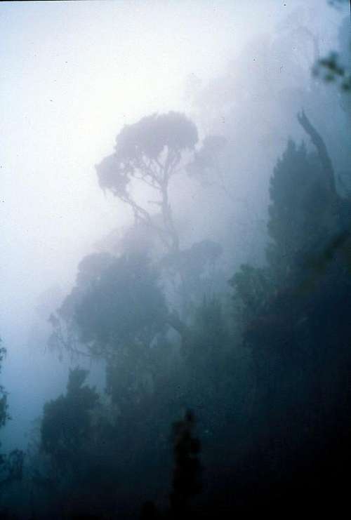
Fog and Trees, Mubuku Valley
The best text on the range is:
Fillipo de Fillipi Ruwemzori, an account of the expedition of H.R.H. Prince Luigi Amedeo of Savoy, The Duke of Abruzzi, Archibald Constable, Dutton, 1908.
There is a recent (2010) trip report on climbing Mt. Standley by Petter Bjørstad here. It includes a few clear photos of the range including Mts. Emin, Speke, and Gessi. A more detailed report by the same author including a movie taken from the top of the peak showing a 360 degree panorama of the range can be seen here
An excellent but outdated climbing guide (most of the glaciers have melted):
H.A. Osmaston and D. Pasteur, Guide to the Ruwenzori: The Mountains of the Moon, Mountain Club of Uganda and West Col Productions, U.K. 1972.
BUT WAIT!!! There was just a new edition of this book published in 2006!!! (after decades of being out of print). It can be purchased at Amazon.com for an enormous fee. It is really good though, with all sorts of information in this book, including an exhaustive bibliography of hundreds of Rwenzori related articles, books, etc.
Both of these books are at the American Alpine Club Library in Golden Colorado
The best map of the range is:
Andrew Wielochowski, Ruwenzori Map and Guide, West Col, 1989. It can be purchased on Amazon.com for about $15 USD.
An inspired early account of exploration and peak climbing in the range and on other African mountains is:
H.W. Tilman, Snow on the Equator, Bell, 1937
(This book was republished in a volume H.W. Tilman the Seven Mountain Travel Books, The Mountaineers, 1983.) This book contains the great description: "Such are the Mountians of the Moon - vying not with the austere splendour and subliity of the Alps and the Himalaya, but by their position, mystery, traditions, and matchless scenery, ranking, surely, amongst the wonders of the earth."
One of the best picture books written by a key figure in getting protection for the range is:
Guy Yeoman, Africa's Mountains of the Moon: Journeys to the Snowy Sources of the Nile, Hamish Hamilton; Universe Books, 1989
A good book with more recent photos is:
David Pluth, Uganda Rwenzori A Range of Images, Little Wolf Press, 1996.
My inspiration and interest in the Rwenzori began after reading: Paul Zahl, "Africa's Mountains of the Moon", National Geographic Magazine, March 1962, pgs. 412 - 434.
Vittorio Sella remains one of the best photographers ever to have lived. An excellent book to own and flip through from time to time for inspiration is: Vittorio Sella, Summit, Aperture Foundation, 1999. The book contains a chapter on the Rwenzori and additionally leaves you wanting to gaze upon Ushba, Gasherbrum IV and so much else.
There is a nice website and movie about the range called "Snows of the Nile" that was released in 2014. It details a trip made by two Boulder, Colorado climbers who won an unusual grant to document the change of glaciation between Sella's time and the present and has some outstanding photography of the range.
The article describing loss of glacial ice in the Rwenzori can be found at:
Citation: Taylor, R. G., L. Mileham, C. Tindimugaya, A. Majugu, A. Muwanga, and B. Nakileza (2006), Recent glacial recession in the Rwenzori Mountains of East Africa due to rising air temperature, Geophys. Res. Lett., 33, L10402, doi:10.1029/2006GL025962. It can be purchased here.
Another article on glaciation in East Africa including the Ruwenzori (written in 1987) can be found here.
Summitpost member tom1725 recently visited the range and wrote this article centered upon the loss of the glaciers.
In recognition of the scientific work carried out by the Duke of Abruzzi, an expedition from Italy returned to the range in 2006. Their web page with related information and a number of Sella's photographs can be found here.
Information about peak fees can be found at Travel Uganda
The group responsible for peak ascents by the Central Circuit:
Rwenzori Mountaineering Services
PO Box 33 Kasese Uganda
Tel. 256-41 237497
email: rwenzorims@yahoo.co.uk
Ascents by the Kilembe Route are managed by Rwenzori Trekking Services. For a list of their tours, go here.
For Skiers: click here.
An important book to read for anyone traveling to Uganda is an autobiographical account of a man who became Idi Amin's personal doctor:
Giles Foden, The Last King of Scotland, 1998
Rwenzori.com is a site set up by people in Uganda. There are photos and articles, as well as commercial opportunities on their website.
"Mirek" posted a photo album of the Rwenzori in 2007 here that shows many pictures of the entire approach circuit up to the Elena Hut, but no pictures above this point on Mt. Stanley.
Information about ascents from DRC can be found at Virunga National Park's page here. I have not heard of anyone going into the mountain this way, recently.
The Rwenzori were mentioned in the 2006 and 2004 American Alpine Club Journals.
Commercial Expeditions
Heather Forest near Guy Yeoman Hut
Because of the logistics of organizing transportation, guides, food, etc. many people use commercial trips to climb Mt. Standley. Below, I have listed several commercial outfitters. I am personally unaquainted with most of these organizations and am not endorsing them, just presenting possible options for those who don't have the time to go it all alone.
Achieve Global Safaris
Adrift Adventure
Uganda Safaris
Churchill Safaris They will design an individual trip around what you want.
Credit Uganda Tours
EWP This site has a nice map of the hiking circuit.
Habari Africa
Standout Adventures
Trips to the Rwenzori on the Web
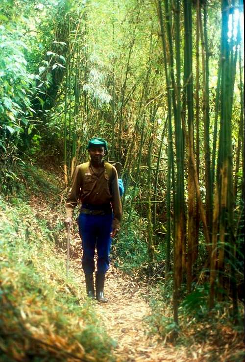
Bamboo Forest, Rwenzori Mountains
Mark Jenkins is a writer for Outside Magazine and went to the range in 2004 where I met him at the Bujuku Hut. His article captures the essence of my thoughts on the Rwenzori.
Cathy O'dowd climbed in the Rwenzori from the (then) Zaire side in 1990 and wrote an article about the trip from this side of the range, including a great photo of the western view of the range.
Scott Yost travelled to the range in 1997 and took many outstanding Photographs. His journal of the trip can be read here.
A wild picture of the trees can be seen at this web site.
Rob Woodall wrote up a nice report with great photos of a 2009/2010 trip to the range that included an ascent of Mt. Stanley. There are some great photos with this report. They had outstanding weather for their ascents!
David Noble visited the range in 1990 and has a great array of photos. Some of them are a bit dated in terms of where the glaciers are, but they are beautiful!
Translate
Thanks
I would like to extend a special thanks to Nelson for scanning the pictures on the page and the route pages. Without his effort the visual reminders of the Rwenzori would be missing.</mushelusenge@yahoo.fr>
Alpinist - May 4, 2010 1:55 pm - Voted 10/10
Mt Margherita closedThe ice cap on Mt Margherita has split creating a 20ft wide crevasse on the main climbing route. The route is closed now while a new route is being made. Source
Tijs - Apr 10, 2013 6:07 am - Voted 10/10
New Route on MargheritaI can confirm, having climbed Margherita last January, that a good new route has been established. There is now quite a long descending rock section between the Stanley Glacier and the Margherita Glacier. The (in)famous ladder is definitely no longer usable; despite previous makeshift elongations, its lowest step is now many meters above the glacier surface. There is still a lot of ice up there, much more than on Kili, but seeing this ladder ending in mid-air, meters above the glacier, makes you realize, that soon it will, sadly, all be gone. I used a different and longer approach than the one described here. One day I may add some info on this route, the Kilembe Trail.
Katethekatelyn - Mar 16, 2016 11:59 am - Hasn't voted
Uganda Wildlife Authority ChangedThe link to Uganda wildlife authority website, http://www.uwa.or.ug is broken because they have a new website here, http://www.ugandawildlife.org/explore-our-parks/parks-by-name-a-z/rwenzori-mountains-national-park
RobSC - Mar 17, 2016 9:07 pm - Hasn't voted
Re: Uganda Wildlife Authority ChangedThanks so much for letting me know! I have fixed the links.
achieveglobalsafaris - May 18, 2017 2:52 am - Hasn't voted
Access Uganda Tours 404 (Page doesnt exist)The rwenzori mountaineering page on Access Uganda Tours doesnt exist anymore. please replace it with http://www.ugandarwandagorillatours.com/uganda/safari-parks/rwenzori-mountains-park.html. More detailed and knowledgeable.
RobSC - May 18, 2017 7:40 pm - Hasn't voted
Re: Access Uganda Tours 404 (Page doesnt exist)Thanks for letting me know! I updated both this and the Rwenzori page.
Muhindo Geoffrey - Jul 21, 2022 1:23 pm - Hasn't voted
Guides and accommodation on the Central circuit routeGuide services and accommodation along the Central circuit route has greatly improved from 2015 to date with the increase in the number of East Africans interested in adventure tourism who use the route as it's more easier, shorter and affordable to them to experience the the Rwenzori ranges in a circuit around the ranges. In 2021, UNDP donated trekking gear, first Aid equipment and stretchers and radio receivers to the guides and porters association operating along the Central circuit route. The Uganda Wildlife Authority has also embarked on expanding and improving the camps along the trail with Nyabitaba camp done and next works will be on Elena camp. The trail also currently have walkboards along the boggy sections towards John Maate hut, Bigo hut, Nyamuleju hut and Lake Bujuku. I enjoyed two summits through the trail in July and December 2021 with a group of climbers organised by Bujuku Eco Tours each time and it was a great experience for the dry season and wet season in Uganda respectively.