
|
|
Area/Range |
|---|---|
|
|
47.51445°N / 121.70929°W |
|
|
Hiking, Mountaineering, Trad Climbing, Sport Climbing, Bouldering, Big Wall, Mixed, Scrambling |
|
|
Spring, Summer, Fall, Winter |
|
|
4824 ft / 1470 m |
|
|
Overview
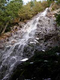 Kamikaze Falls
The Mount Si Natural Resources Conservation Area (NRCA) is one of the most climbed regions of Washington State. The centerpiece of the area is a steep, rugged mountain ridge spanning across the Mount Si NRCA mostly west-east (with a couple of short offshoot ridges and highpoints). Although most recreational use occurs on popular destinations Mount Si, Little Si, and Mount Teneriffe, the lesser known peaks of the area (Green Mountain, Dixie Peak, Blowdown Mountain, and Crater Lake Mountain) also offer substantial recreational opportunities for outdoor enthusiasts.
When originally created in 1987 the Mount Si NRCA encompassed only 4,670 acres. However, expansions and land acquisitions over time have increased the size of the Mount Si NRCA to at least 13,363 acres. The Mount Si NRCA was created to help protect and preserve several small stands of old-growth forests found in the area, sensitive flora, and unique geological features. The landscape is comprised of highly metamorphosed rocks, remnants of an ancient oceanic plate volcano. The area also is home to large mammals such as cougars, bears, bobcats, deer, and mountain goat.
Common Recreational Activities
 Haystack Scramble
Each major highpoint of the Mount Si NRCA provides advantages for specific recreational activities.
MOUNT SI:
The namesake, and easily the most popular, highpoint of the area. Mount Si receives 80,000-100,000 hikers annually. The Mount Si Trail is considered by many to be a good conditioner hike, climbing 3300 vertical feet in elevation in a four-mile span. Mount Si has also been known as a popular hang-gliding location, as well as a popular rock-climbing location on its extremely steep, rocky westside. The "Haystack" near the summit is a popular, rocky YDS Class 3 scramble.
LITTLE SI:
Mount Si's much-smaller sister peak, located on the southwest corner of the Mount Si NRCA. Little Si offers a classic YDS Class 1 trail to its summit, as well as numerous YDS Class 4 & 5 rock-climbing and bouldering opportunities along the sides of the mountain.
MOUNT TENERIFFE:
 Green (left), Teneriffe (center), Dixie (right)
Another popular peak of the area, Mount Teneriffe offers scenic 360-degree views of the Mount Si NRCA, Snoqualmie River Valley, other nearby peaks along the I-90 Corridor, and Mount Rainier. The most popular summit approaches include the Mount Teneriffe Road-Trail route which is YDS Class 1, and the Southwest Ridge route which is Class 2 (with potential for Class 3 bypass sections, in certain areas). Mount Teneriffe is a popular snowshoe hike during winter months.
GREEN MOUNTAIN:
Located northeast of Mount Teneriffe, on the east side of the Mount Si NRCA. The highest point of the Mount Si NRCA at 4824' elevation, Green Mountain offers lengthy summit hikes during summer and autumn months, and offers great steep snowshoe climbs during winter and spring months. The mountain offers many locations for great views of the surrounding areas.
DIXIE PEAK:
Despite being located in the center of the Mount Si NRCA, Dixie Peak is commonly overlooked and underappreciated. Wedged between Crater Lake to its west and Rachor Lake to its east, Dixie Peak (also known as Rachor Mountain) offers a great destination for snowshoe hikes during winter months and backcountry/bushwhack hikes during summer months. The 360-degree views from Dixie Peak, especially from its northern false summit, have been said by multiple hikers to rival the views of its more popular sister peaks (Mount Teneriffe, Mount Si).
BLOWDOWN MOUNTAIN:
 Blowdown (left) and Crater Lake Mountains (right)
Located northeast of Mount Si, near the center of the Mount Si NRCA. Blowdown Mountain (also known as Point 4560+ or Peak 4560+) is heavily forested with evergreen trees and offers limited views from its summit. However, what it lacks in viewpoints it more than makes up for in offering a great destination for possible snowshoeing (winter months), hiking (summer months), bird/wildlife watching (annually), and geocaching (annually).
CRATER LAKE MOUNTAIN:
Perhaps the most unknown, unvisited, and forgotten highpoint of the Mount Si NRCA. Crater Lake Mountain is nestled only a short distance north of Blowdown Mountain. Crater Lake Mountain offers great scenic views of Dixie Peak and Blowdown Mountain from the bare eastside of the summit, while the heavily treed westside of the summit offers few good viewpoints. Crater Lake Mountain offers a great location for snowshoeing during winter months and backcountry/bushwhack hikes during summer months.
MOOLOCK MOUNTAIN:
Located near the northeast corner of the Mount Si NRCA is Moolock Mountain. The peak and three tiny lakes (Lake Moolock, Lake Nadeau, and SMC Lake) located on its west side have been under Department of Natural Resources (DNR) jurisdiction for many years. The original DNR Management Plan for the Mount Si NRCA listed the upper slopes of Moolock Mountain (and those three lakes) only as a "study area" within the NRCA protection zone. Over time, as more land nearby has been acquired for expansion of the Mount Si NRCA, Moolock Mountain and its three neighboring lakes have been under the supervision of DNR as if within the Mount Si NRCA boundary. DNR (and maps) might officially recognize Moolock Mountain as part of the Mount Si NRCA sometime in the near future.
Getting There
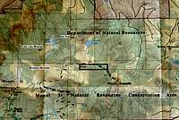 Closeup (Map) of Major Highpoints
North Bend, Washington, is the closest city to the Mount Si NRCA. The SE Mount Si Road is the most accessible entrance to the area. Little Si and Mount Si have their own dedicated trailheads, while the "School Bus Turnaround" area offers more-direct access to the other remaining highpoints of the Mount Si NRCA (except Green Mountain).
For a complete mapped area of the entire Mount Si NRCA, including entrances, parking lots, and/or trailheads, please purchase Green Trails Map #206S.
To get to the SE Mount Si Road, use one of the following driving directions from I-90:
I-90, EXIT #31:
Take the exit and head north along North Bend Blvd (also known as Bendigo Blvd S or SR-202).
Turn right at the lighted intersection for E North Bend Way/432nd Avenue SE.
In 0.6 miles, turn left onto SE Mount Si Road.
I-90, EXIT #32:
Take the exit and head north along 436th Avenue SE.
Continue driving about 0.5 miles to the "T" intersection at SE North Bend Way.
Turn left onto SE North Bend Way and drive west for 0.25 miles.
Turn right onto SE Mount Si Road.
------------
From the point of turning onto SE Mount Si Road:
LITTLE SI TRAILHEAD:
Soon after turning onto SE Mount Si Road, head over the bridge and stay on the road where you will see the Little Si trailhead on your left about 1000 feet from the bridge. The trailhead parking lot is well marked.
MOUNT SI TRAILHEAD:
After turning onto SE Mount Si Road, drive for over two miles. The Mount Si Trailhead parking lot is on your left, and is well marked.
SCHOOL BUS TURNAROUND (a.k.a. "Fire Road"):
Follow SE Mount Si Road approximately 1.25 miles beyond the Mount Si trailhead/parking lot to the "School Bus Turnaround" area. On your left is blocked fire road. Park here but make sure not to block the entrance to the fire road. Do not park here during school days unless after 5:00 PM.
Red Tape
Beginning during 2011, parking areas and trailheads within and for the Mount Si Natural Resources Conservation Area (NRCA) require a Discover Pass to be in each vehicle during the visit. Failure to have a Discover Pass visible within a parked vehicle at these locations can result in a substantial fine. For more information regarding the Discover Pass, please visit the official website.Dogs must be on-leash at all times while traveling in the area.
No camping is allowed in the Mount Si NRCA.
For the "School Bus Turnaround" (a.k.a. "Fire Road"), do not block the gated entrance to the road, and do not park at that location during schooldays unless after 5:00 PM.
Camping
No camping is allowed in the Mount Si NRCA.External Links
For more specific information regarding any peak of the Mount Si NRCA, click on the link to that peak's dedicated SP page.For potential recreationalists of the Mount Si NRCA, reference Green Trails Map #206S (Side A).
The Mount Si NRCA website provided by the Washington State Department of Natural Resources.