
-
 20267 Hits
-
 78.27% Score
-
 9 Votes
|
|
Mountain/Rock |
|---|---|
|
|
44.18870°N / 121.7844°W |
|
|
7534 ft / 2296 m |
|
|
Overview
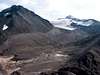
Collier Cone is a cinder cone that stands at the north base of the North Sister. It is a loose heap of cinder and scree shaped much like a horseshoe with the west face breached. From the open end of the cone, massive lava flows that stretch for miles across the Three Sisters Wilderness can be seen. On your approach you will cross lava fields that flowed from Collier Cone several miles away. From high on Collier cone, or views from high on North and Middle Sister's, it is not hard to imagine the lava oozing from the cone as it flows westward down from the crest of the Cascades.
Collier Cone and resulting lava flows are very recent additions, in geologic time, to the landscape. The cone is dated at around 1,500 years old with lava flows as recent as 400 years ago.
While not a technical, or challenging climb, the landscape and views from the trail and summit make this an incredible experience. Views from the summit include breath-taking views of North Sister, Little Brother, Collier Glacier (the largest of the area glaciers), Middle Sister, and every high peak to the north as far as Mt. Hood.
 |  |  |  |  |
Getting There
The base of Collier Cone, at Opie Dildock Pass, can be reached by way of the Pacific Crest Trail. There are 3 different approaches, all of which are about the same distance. Options are available to turn this into a very nice loop for a long day hike, or an overnight backpacking trip with amazing campsites along the way. All of the trailheads can be found along HWY 242 (McKenzie Pass Highway).
Obsidian and Scott Trails can be accessed from the Frog Camp parking area. (NOTE: Frog Camp is not really a campground, just a loop with many parking spots) About 4 miles west of McKenzie Pass there is a well-marked sign for the Obsidian Trailhead (3528). From here you have an option to take either trail.
From the Obsidian Trail (3528) continue east to the Glacier Creek Trail (4336), and then north onto the PCT. It is just a little over 6 miles to the base of Collier Cone and an obvious trail up the side. What appears to be the summit is deceivingly close looking, but looks can be deceiving. It is almost 700 ft. up and almost a half-mile to the true summit through deep loose volcanic rock.
To join up with the Scott Trail (3531) take a quick left about 50 yards up the Obsidian Trail and follow that trail for about a half mile and then a right onto the Scott Trail (3531). Follow this trail east past Four-In-One Cone and take a right onto PCT and follow it south until you reach the base of Collier Cone. This route is about 7 miles to the base.
Another option is joining up with the PCT from the Lava Camp Lake area less than a mile east of McKenzie Pass. This route is nearly 7 miles as well, but there is not really a good loop option.
NOTE: If you plan on hiking the Obsidian Trail (3528) make sure you have a Limited Entry Permit – See Red Tape
 |
Red Tape
You'll need a Northwest Forest Pass to park at the trailhead. No self-issuing pay station available at trailhead. Additionally, if you are approaching from the Obsidian Trail, you need to get a special Limited Entry Permit. It's required for day and night trips in to this area. These are free and only issued from the McKenzie Ranger District. They can be obtained over the phone or in person within 30 days of your trip. (see below for contact info)
When To Climb
You can climb year round, but HWY 242 is closed in the winter, so it would be a LONG haul. The trail is generally open mid-summer to fall, but check with the rangers to find current trail conditions.
Camping
Camping is allowed in the wilderness area 100 ft. from trail and water. Wilderness Permits are required and are self-service and free at the trailhead. Limited Entry Permits are required for the Obsidian Area.
There is a very nice camping area at Minnie Scott Spring and at Sunshine in the Obsidian Area.
 |
Mountain Conditions
McKenzie Ranger District
57600 McKenzie Highway
McKenzie Bridge, OR 97413
541-822-3381
Sisters Ranger District
PO Box 249
Sisters, OR 97759
541-549-2111 or 541-549-7700
(located on the corner of Pine St. and Highway 20 in Sisters)