
-
 68185 Hits
-
 96.87% Score
-
 63 Votes
|
|
Area/Range |
|---|---|
|
|
37.35680°N / 118.7818°W |
|
|
Hiking, Mountaineering, Trad Climbing, Ice Climbing, Aid Climbing, Big Wall, Mixed, Scrambling, Skiing |
|
|
Spring, Summer, Fall, Winter |
|
|
Overview
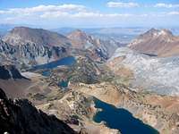
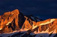
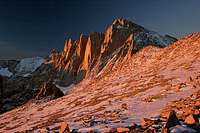
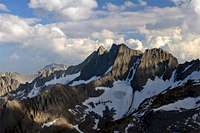
The High Sierra is arguably the most spectacular range of mountains in the continental United States. Soaring granite peaks, crystal clear mountain streams, the shimmering reflection of clouds in stunningly azure alpine lakes, and verdant meadows painted brilliantly with wildflowers in the spring and early summer stir the imagination and beg for exploration. It is not for nothing that the Sierra is known as the Range of Light.
This fitting appellation was given to the mountains by none other than John Muir. His name should need no introduction to readers: champion of the wilderness, founder of the Sierra Club, naturalist who was first to put forth the theory of glaciation to explain the fantastic geology in Yosemite Valley, and an accomplished mountaineer. He claimed the first ascents of Mt. Ritter, Cathedral Peak--at the time, the hardest rock climb America had yet seen--and countless other Sierra peaks. He is, in short, to use Steve Roper's apt words, "one of the Sierra's greatest figures."
As appropriate as Muir's description of the Sierra Nevada is, equally fitting is that his name should grace arguably the most spectacular scenery in the range. First designated for protection in 1964, the John Muir Wilderness extends for over a hundred miles along most of the east side of the range, taking in the most dramatic aspects of the Sierra. The wilderness is bounded on its north by the equally beautiful Ansel Adams Wilderness, on its west by Sequoia and Kings Canyon National Parks, and on its southern fringes by the Golden Trout Wilderness. To the east lie the beginnings of the desert, a starkly barren contrast to the life and beauty that springs forth from the high peaks.
The wilderness is the largest in California, covering some 580,323 acres in all. It also lays claim to the highest point in the contiguous United States, with elevations within the wilderness ranging from 4,000 ft all the way to 14,494 feet at the summit of Mt. Whitney. Unfortunately, to go along with these superlatives, it is also the most heavily visited wilderness in the state. Fortunately, the crowds are easy to lose the moment you step off the trail. With just a little effort, it is easy to find oneself walking through unspoiled nature, just as John Muir did over a hundred years ago.
Red Tape
General rules, permits and quotas
The wilderness is jointly managed by Inyo National Forest, which manages eastern access to the wilderness, and Sierra National Forest, responsible for western access. (Almost all popular trailheads are managed by Inyo NF; only a few relatively lightly used trailheads around the west-side reservoirs--Wishon Reservoir, Courtwright Reservoir, Lake Thomas Edison, and Florence Lake--are managed by the Sierra National Forest. The majority of High Sierra peaks are most easily reached out of the east). Like most wilderness areas in the state, the area is subject to considerable red tape.
Convict Creek area from Red Slate Mountain.
In addition to the standard wilderness regulations, wilderness permits are required for overnight stays, campfires are prohibited above 10,000ft, and bear cannisters are required if camping along the most popular trails. Current details can be found in the Inyo National Forest wilderness regulations. With the exception of the Mt. Whitney area, detailed below, dayhikers can explore the area unencumbered by bureaucracy.
Given its outstanding scenery, the area is extremely popular with backpackers, and a quota system is in effect from May 1st through Nov 1st each year. 60% of permits are reservable ahead of time for a $5/person fee, while the remaining permits are obtainable free on a first come-first served walk-in basis, starting 11am the day before your hike. (There is one notable exception to this rule: A $15/person fee applies for Whitney Zone permits, and 100% of permits for that trail are reservable ahead of time). Contact the USFS ranger station responsible for your entry trailhead to procure the permit; this contact information can be found below.
Inyo NF (all east side trailheads): Quotas - permit reservations - availability.
Sierra NF (all west side trailheads): Quotas - permit reservations.
Little Lakes Valley
Bear Creek Spire.
There is no red tape for this area during summer. However, during the winter months (typically November through April), Rock Creek Road is closed three miles east of Rock Creek Lake, and a California Sno-Park permit ($5/day, or $30/season) is required to park here at this time. Fines for non-compliance are fairly stiff, $75 per infraction. Peaks affected by this permit requirement include the peaks along the Sierra Crest between Mt. Mills and Bear Creek Spire, as well as the peaks around Pioneer Basin (Mt. Huntington, Mt. Stanford, and Mt. Morgan (N)).
California Bighorn Sheep Zoological Area
The area around the Sierra Crest between Sawmill Pass and Baxter Pass, and from Shepherd Pass to Vacation Pass, is closed seasonally/year-round to protect bighorn sheep. (You also can't take your pet goat with you when you visit these areas!) Restrictions are as follows:
- All cross-country travel above 11,000' is prohibited east of the John Muir Trail and west of the Sierra crest from North Dragon Pass on the south to Sawmill Pass trail on the north year-round.
- All cross-country travel is prohibited in the basin south of Woods Lake, and a mile-long section north along the Sierra crest from Sawmill Pass and the 11,000' contour to the west.
- All cross-country travel is prohibited east of the Sierra crest between Dragon Peak and Sawmill Pass between July 1 and December 15.
- Williamson Bowl is open only between December 15 and July 15.
- George Creek and Mt. Williamson's SE Ridge are open only between Dec 15 and Jan 1, and between April 15 and May 15.
These areas are marked on the USFS wilderness map, "A Guide to the John Muir Wilderness and Sequoia-Kings Canyon Wilderness." (This map, which is too large to use out on the trail but is excellent for planning purposes, may be ordered online from Sequoia National Forest). The peaks affected by the closures include Dragon Peak, Dragon Tooth, Mt. Mary Austin, Black Mountain, Diamond Peak, Peak 3984m, Mt. Baxter, Acrodectes Peak, Peak 3914m, Peak 3903m, Indian Rock, Mt. Williamson, Mt. Barnard, Trojan Peak, and Mt. Carl Heller.
Mt. Whitney Zone
The Mt. Whitney trail and the cross-country route up the North Fork of Lone Pine Creek are the exceptions to the rule that Sierra dayhikers are exempt from permit requirements. Between May 1 and November 1, all hikers using the Mt. Whitney trail beyond Lone Pine Lake (about two miles in from the trailhead) are required to have a permit, regardless of whether your eventual destination is Mt. Whitney via the tourist route or one of any number of other peaks. All permits for the trail are obtainable by reservation, and the popularity is such that a lottery is held to determine permit recipients. (Any unclaimed permits are available on a walk-in basis as usual). Peaks affected by this permit requirement include Mt. Whitney via the main trail, Mt. Muir, Mt. McAdie, Mt. Irvine, as well as the technical routes on Thor Peak.
Mt. Whitney.
As of 2007, visitors who plan on day hiking up the North Fork of Lone Pine Creek (e.g. to climb Mt. Russell, Mt. Whitney via the East Face/East Buttress/Mountaineer's Route, etc.) must carry a North Fork of Lone Pine day hike permit. This affects all visitors who will hike beyond Lower Boy Scout Lake. There is no quota set for these permits, so no reservation is needed.
As of this writing, according to several rangers it is legal to hike out on the Whitney trail after having ascended the Mountaineer's Route on Mt. Whitney, so you can safely return via this route at any time in good conscience. If you need to use the Whitney trail to access your objective(s), but haven't obtained a permit--perhaps because the notion of doing so is offensive if you're not trudging up Whitney with the crowds, or perhaps because the idea of planning six months ahead strikes you as ludicrous--an early (substantially pre-dawn) start may avoid the rangers out on patrol. Bob Burd notes that his group headed out at 5am on one occasion and encountered a ranger checking permits up at High Camp before 8am.
Sequoia/Kings Canyon backpacking access
Wilderness permits are issued based on the departure trailhead. Despite this, if you enter the John Muir Wilderness and cross the Sierra Crest to camp in the Sequoia Kings Canyon backcountry, the park requires that you sit through a lecture about wilderness etiquette before receiving the permit. In previous years, it was possible to reserve a permit ahead of time and pick this up in a drop box, so that one could have an early start the next morning. With the new policy and relatively late hours kept by ranger stations, this is now impossible.
Contact Information
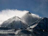
Sierra Wave above Basin Mtn.
Sierra National Forest
Contact the Sierra National Forest to obtain permits for entry from the west (Wishon Reservoir, Courtwright Reservoir, Lake Thomas Edison, and Florence Lake area trailheads):
High Sierra Ranger District office
High Sierra Ranger District
29688 Auberry Road
P.O. Box 559
Prather, CA 93651
559-855-5355
April 1 through November 30
Hours: 8:00 am to 4:30 pm, seven days a week.
December 1 through March 31
Hours: 8:00 am to 4:30 pm, Mon through Fri.
The ranger station is located along SR168, just west of Prather.
Dinkey Creek visitor center
During summer months, it is possible to obtain wilderness permits for the Wishon and Courtwright Reservoir area trailheads from the Dinkey Creek visitor center, located along Dinkey Creek road, a couple of miles past the turnoff for the reservoirs. (It is signposted and easy to find). Phone: (559) 841 3404. Summer hours are 8am-4.30pm, seven days a week.
High Sierra visitor center
When Kaiser Pass Road is open (typically May through Oct), wilderness permits for the Lake Thomas Edison and Florence Lake areas can be obtained from the High Sierra visitor center. Phone: (559) 877 7173. Summer hours are 8am-4.30pm, Thurs-Sun.
Inyo National Forest
Contact the Inyo National Forest to obtain permits for east-side entry (Mammoth Lakes south to Lone Pine):
Mammoth Lakes area
Mammoth Ranger Station and Visitor Center
760-924-5500
P.O. Box 148
Mammoth Lakes, CA 93546
Open all year, 8:00 am to 5:00, seven days a week.
Bishop area
White Mountain Ranger Station
760-873-2500
798 North Main Street
Bishop, CA 93514
Open all year, 8:30 am to 4:30, Mon-Fri in winter.
Lone Pine area
Mt. Whitney Ranger Station
760-876-6200
640 S. Main Street
P.O. Box 8
Lone Pine, CA 93545
Closed in winter .
Interagency Visitor Center
Lone Pine
760-876-6222
P.O. Box R
Lone Pine, CA 93545
Junction of Hwy 395 & Hwy 136
Open all year, 8:00 am to 4:50 pm, seven days a week.
Wilderness permit office
For questions about conditions, contact the ranger station nearest your entry trailhead, although don't expect much in the way of useful information. For general questions about permits and reservations, contact the Wilderness Permit Office:
Wilderness Permit Office
Inyo National Forest
351 Pacu Lane, Suite 200
Bishop, CA 93514
Wilderness Information Line: (760) 873-2485
Reservation Line: (760) 873-2483
Fax: (760) 873-2484
Open Monday through Friday, mid-October to mid-May, 8:00am to 4:30pm.
The rest of the year, open 7 days a week, 8:00am to 4:30pm.
When To Visit
Most people visit the John Muir Wilderness during the summer and fall months, typically June through October. Visitation is heaviest during July and August, once most of the snow has melted and all access roads are open. Summer thunderstorms are relatively common during these months.
Winter and early spring climbs are possible, but access to the wilderness at this time is generally possible only from the east. Many east-side trailheads are relatively low-elevation, and are accessible year round. See individual trailhead information for further details.
Current Conditions
NWS Forecast for Bishop.
Sierra National Forest: Weekly recreation report and High Sierra Ranger District recreation report (campground/road information).
Inyo National Forest: Mono/Mammoth Ranger District conditions report - White Mtn/Mt. Whitney Ranger District conditions report.
Maps
Winds scour snow from Mt. Morrison.
In addition to the usual USGS 7.5' topographic maps covering the wilderness, a number of other area maps can be useful.
National Forest maps
Sierra National Forest and Inyo National Forest both publish maps showing forest trails, roads, and land ownership within their areas of jurisdiction. These two maps are not suitable for hiking or climbing purposes, but they are very useful for locating obscure Forest Service roads and area campgrounds.
Topographic maps
The Forest Service publishes an excellent topographic map (1:63360) entitled A Guide to the Sequoia-Kings Canyon and John Muir Wilderness. This is huge--it's more akin to a kite than a usual map--but is excellent for planning purposes. The bighorn sheep closures are clearly marked.
Tom Harrison Maps publishes a series of waterproof topographic maps (1:63,360, 80-foot contours) that covers the entire Eastern Sierra. This doesn't cover the John Muir Wilderness in its entirety, but the maps suffice to cover the areas most of interest to climbers: Mammoth High Country, Mono Divide High Country, and Kings Canyon High Country. These maps are particularly useful for planning as they include trail mileages.
Where to buy
Forest Service maps can be bought over the phone or through the mail from the National Forest Store. Tom Harrison Maps can be ordered online from the company's website (see link above), or found in most outdoors stores.
Books
Norman Clyde Peak from Temple Crag.
Climbing-related
RJ Secor, The High Sierra: Peaks, Passes, and Trails - the bible of the High Sierra. Covers trails, cross-country routes, and peaks throughout the area.
Steve Roper, Climber's Guide to the High Sierra - a predecessor to Secor's book. Terse route descriptions and occasionally "old-school" (some may say sandbagged) ratings, but includes some valuable nuggets of information not found in Secor's guide.
John Moynier and Claude Fiddler, Sierra Classics: 100 Best Climbs in the High Sierra - brief route descriptions for an interesting and varied selection of climbs, all mixed in with some entertaining anecdotes. Covers routes throughout the Sierra, with many chosen from the John Muir Wilderness.
General reading
Phil Arnot, High Sierra: John Muir's Range of Light - not so much a guide book as it is a collection of short essays about special places and times in the Sierra, most off-trail. The writing is awkward and in need of a good editor, but the author's enthusiasm comes through forcefully, making this a compelling read and a personal favourite. It is next to impossible to read the book and not start planning one's next foray into the Sierra backcountry.
George Wuerthner, California's Wilderness Areas, The Complete Guide Vol 1: Mountains and Coastal Ranges - the first volume in a two book series covering all wilderness areas in the Golden State. He provides a brief overview of each wilderness, and includes just enough information to whet the reader's appetite for a visit.
Links and Further Reading
A collection of Muir's writings.
John Muir biography.
Wilderness.net description.
AskaRanger - Sep 9, 2012 1:17 pm - Hasn't voted
2012 updateMt Whitney Zone: Mt Whitney Zone Day Use permit is required for all routes, includes the North Fork of Lone Pine Creek. Contact Information: Mt Whitney Ranger Station in Lone Pine does not issue permits or sell maps, all services for visitors were moved to the Eastern Sierra InterAgency Visitor Center south of town. On the north end of Inyo National Forest, wilderness permits are issued (and visitor services like bear can rental and maps)are at: Mono Basin Scenic Area Visitor Center North of Lee Vining, East side of Hwy 395, overlooking Mono Lake. (760) 647-3044 Closed in winter. Wilderness Permit Office for Inyo National Forest Reservations are made online, no more mail or fax. Talk to a person: (760) 873-2483 Recorded Wilderness Information: (760) 873-2485
Bob Burd - Sep 21, 2012 12:57 am - Voted 10/10
Bighorn Sheep ZoneThe Bighorn Sheep Zone restrictions have been removed as of 2011.