

|
|
Area/Range |
|---|---|
|
|
39.11780°N / 106.4447°W |
|
|
Hiking, Mountaineering, Skiing |
|
|
Spring, Summer, Fall, Winter |
|
|
Overview
The Sawatch Range, in central Colorado, contains the highest mountains in the Rockies. The range tops out at 14,440' Mount Elbert. It contains 15 fourteeners and more than 300 peaks above 12,000' elevation. About one third of Colorado's 100 highest ("centennial") peaks lie in the Sawatch. The Sawatch Range covers a lot of ground north to south, measuring 100 miles long. A long and high portion of the North American Continental Divide winds through the Sawatch. However, all but one of the Sawatch fourteeners lie east of the Divide
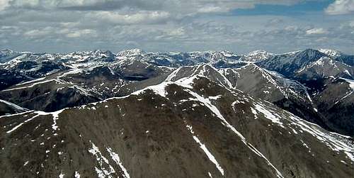
The Sawatch Range: A Sea of Mountains
"Sawatch" comes from the Ute word meaning "blue-green color," or "waters of the blue earth," a descriptive term for this "sea" of mountains.
There is not a great deal to attract rock climbers to the Sawatch. But for those who seek exhilarating hikes to summits above timberline, the Sawatch Range has no equal. This range is known for bulky mountains -- steep approaches and relatively gentle climbs above timberline. You can reach the majority of Sawatch summits with a class 2 talus climb.
Technical Climbing
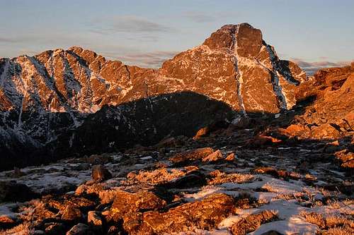
The Sawatch is not a complete loss for technical climbers, however. There have been some big climbs on the Mount of the Holy Cross, the Ellingwood Ridge of La Plata, the north face of Truro Peak, and on 13,951' Ice Mountain, which is steep on all sides. The Refrigerator Couloir, on Ice Mountain's north face, is one of the toughest mountaineering routes in the Sawatch. It is considered by some to be the most dangerous route in the state. The 1000' north wall of Truro Peak was not climbed until 1970.
Access
U.S. Highway 24/285 parallels the Sawatch Range on the east, from I-70 near Vail, all the way down to the town of Saguache (alternate spelling of Sawatch) in the San Luis Valley. Two paved roads cross the Sawatch Range. They are State Highway 82 (Independence Pass) and U.S. Highway 50 (Monarch Pass). Access to Sawatch trailheads is generally possible by road, thanks in part to the extensive mining activity that took place a hundred years ago.
The Sawatch Range is conveniently divided into three regions, Northern, Central, and Southern.
Northern Sawatch
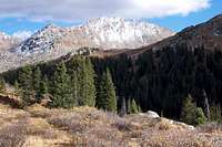
Although it is bordered by Interstate 70, and is only 100 miles from downtown Denver, the Northern Sawatch is probably the least well known part of this Range. It is the smallest part also, containing only 16 named summits over 12,000'. Only one mountain reaches to 14,000 feet above sea level. That one mountain, however, is very well known, the famous Mount of the Holy Cross. This mountain is the undisputed centerpiece of the Holy Cross Wilderness, part of the White River National Forest. It receives many visitors annually.
 Mount of the Holy Cross
Holy Cross Wilderness
In 1873, a government survey party, which included the famous photographer, William H. Jackson, split into two groups, one to climb and one to photograph the Mount of the Holy Cross. The signature snow formation of this peak was already well known in the territory by this time. Both the climbing group and the photography group were successful. Mr. Jackson's photographs to this day show the clearest cross image ever photographed. Some accuse him of doctoring the photographs to embellish the peak's reputation. Embellished or not, the photographs drew countless thousands of visitors and pilgrims to this area in the years that followed. The level of interest has not diminished to this day. 164 miles of wilderness trails accommodate these visitors, many of whom come only to photograph or to climb Mount of the Holy Cross. Visit rockymountainscenery.com for a 360-degree panorama from the Holy Cross summit.
 Mount Jackson
The Holy Cross Wilderness is a "water wilderness." It is dotted with innumerable pools and cascades. It receives a lot of moisture, and its streams overflow when the snow melts in spring. In Colorado, that much water provokes bitter competition among environmentalists, municipalities, and farmers. The Holy Cross Wilderness has been the subject of ugly legal battles over water.
You might think that the Mount of the Holy Cross is the only summit of interest here. Not so. Other prominent summits in the Holy Cross Wilderness include Mount Jackson, Gold Dust Peak, Grouse Mountain, and Whitney Peak.
Also see Northern Sawatch Range.
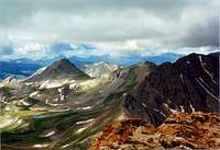
Central Sawatch

Clear Creek, CPW
South Willow Creek
The Central Sawatch subrange contains well over half of the Sawatch mountains, including the four highest. Geographically, the fuzzy boundaries are:
- * Horseshoe Creek (flows northeast) and Fryingpan River (flows northwest) form the northern boundary
- * Castle Creek (flows north into Aspen) on the far northwest
- * Taylor River (flows south) on the west
- * Texas Creek (flows west) and Cottonwood Creek (flows east) form the southern boundary
- * Arkansas River (flows south) on the east
The Central Sawatch Range is 40 miles long from north to south, and varies from 20 to 30 miles wide. Leadville, Aspen, Taylor Park Reservoir, and Beuna Vista mark its four corners. Within these 1000 square miles are hundreds of mountain peaks, innumerable small lakes, and the origins of rivers that provide water to much of the western United States. It is indeed a grand piece of the Rocky Mountains.
Trying to characterize the central Sawatch mountains, or any range this large, is like the proverbial blind men describing an elephant. A climber on Twining Peak sees endless peaks bridged together with skinny ridges, making for excellent scrambling. He ascends a ridge requiring exposed class 4 moves above steep slabs of granite. Another climber ascending the Mount Massive trail sees an endless pile of talus and thousands of acres of rocks above 14,000 feet. You will find a lot of granite in these mountains, solid rock by and large, and that makes for excellent climbing.
Major Summits

Mt Elbert
Mount Elbert and Mount Massive are the second and third highest peaks in the lower 48 States, and the highest two in the Rockies. They dominate the skyline southwest of Leadville, north of Twin Lakes. Both mountains offer an assortment of ascent routes and wonderful climbing experiences for the prepared. Despite their lofty heights, they are easy climbs, like most peaks in the Sawatch Range. Congress set aside Mount Massive and 30,540 surrounding acres as a wilderness area in 1980. See below.

La Plata Peak
La Plata Peak is Colorado's 5th highest mountain, and I think one of its most beautiful. La Plata's long, sweeping ridges and steeper slopes give it a unique character among the central Sawatch fourteeners. The Ellingwood Ridge, or northeast ridge, is rugged and spectacular, worthy of its status as a classic Colorado climb.

Three Apostles
North Apostle, Ice Mountain, and West Apostle anchor a two-mile stretch of the Continental Divide as it crosses west to east through the heart of the central Sawatch mountains. Ice Mountain is the highest of the three, and almost the highest Sawatch mountain on the Continental Divide, at 13,951'. It is a technical climb, even by the easiest route. North Apostle and West Apostle are less rugged. Together, the group are a spectacular and easily recognized reference point from many of the surrounding areas.

Mt Columbia
Mounts Harvard and Columbia anchor the collegiate peaks group, northwest of Buena Vista. The two summits are only 2 miles apart and are often climbed together, although it is not a slam dunk. Large, speckled and striped, granite blocks make Mount Harvard's summit unique. The rock on both mountains is some of the Rockies' best.
In the interest of keeping this page to a readable length, I won't list any more major summits for the central Sawatch. But there are more, many more, including several more above 14,000 feet. Happy exploring!
Hunter-Fryingpan Wilderness
Geissler Mountain
The Hunter-Fryingpan Wilderness is nestled in a set of lower Sawatch mountains north of Independence Pass and south of the Holy Cross Wilderness. It consists of some 82,000 acres of pristine Sawatch country. Speaking of acreage, the Williams Mountains dominate the wilderness area, while the highest summits border the Wilderness on the east. These are Mount Oklahoma, Deer Mountain, and Twining Peak on the Continental Divde. In between lies Geissler Mountain.
As the name implies, Hunter-Fryingpan includes the Fryingpan River and Hunter Creek, both of which are rich, high altitude trout streams. The Hunter Tunnel diverts water from Hunter Creek, through the Continental Divide, for the benefit of Front Range communities.
Mount Massive Wilderness
All of the Mount Massive Wilderness lies above 10,000' elevation. It is due to a technicality that it exists as a separate wilderness. So designated in 1980, the Mount Massive Wilderness is adjacent to the Hunter-Fryingpan Wilderness, with nothing but the Continental Divide to separate them. It was originally proposed as an addition to the Hunter-Fryingpan. Approximately 2500 of the 30,540 acres are managed by the U.S. Fish and Wildlife Service. It is Colorado's first and only Fish and Wildlife wilderness area. The Wilderness wholly contains a single ranked summit, and 20 miles of trails, including part of the Colorado Trail.
Collegiate Peaks Wilderness
Collegiate Peaks Wilderness
In contrast to the solitude found in the Hunter-Fryingpass Wilderness, the Collegiate Peaks Wilderness is a busy place, where there are countless high summits and over 100 miles of well used trails. The beauty of this place and ease of access make it an ever popular playground for thousands of visitors annually. The action of ancient glaciers left behind many U-shaped valleys, alpine cirques, and high altitlude lakes. The Colorado Trail provides hiking opportunities among the lower eastern summits. Recreational opportunities abound year around.
The boundaries of this Wilderness were gerrymandered for the benefit of mining companies anxious to preserve prospective sites for extraction of minerals. Much of the land surrounding La Plata (silver) Peak, for example, was excluded. Still, the Wilderness contains eight fourteeners and 40 miles of the Continental Divide.
Southern Sawatch
Major Summits
The southern portion of the Sawatch Range contains four fourteeners, and gradually tapers off in elevation and breadth the further south you go. It includes a long portion of the Continental Divide. U.S. Highway 50 crosses the range through this region, including Monarch Pass which crosses the Divide at 11,312'. Below, I highlight several of the major mountain peaks in the southern Sawatch.

Mt Princeton
Mount Princeton is a monarch in the Sawatch Range, and one of the most visible peaks in Colorado. It rises 7400' above the Arkansas River just 8 miles from Johnson Village on US 285. It is the southernmost one of the Collegiate Peaks. A case could be made for placing Princeton in the central Sawatch region, but geologically it fits better with the southern group. Mount Princeton Hot Springs Resort is situated at the base of this mountain, along Chalk Creek. Visit Grant's excellent Mount Princeton page for more information and photos of this mountain.

Mt Antero
Mount Antero is the next Sawatch fourteener to front the Arkansas River valley on the eastern side. Like its neighbor, Mount Princeton, Antero is highly visible from U.S. Highway 24 between Johnson Village and Salida. Mount Antero is the highest mountain in the southern Sawatch, at 14,276'. It is the 10th highest mountain in Colorado. Antero and its neighbor Mount White are well known for the wealth of gems and crystals that have been mined from their slopes. A network of well traveled 4WD roads reach to within a short distance of either summit.

Shavano Group
The Shavano group contains the remaining fourteeners of the Sawatch Range, namely Tabeguache Peak and Mount Shavano. Mount Shavano fronts U.S. Highway 285 just north of Poncha Springs. The two fourteeners are separated by 0.7 miles and are often climbed in combination. The Jennings Creek approach from the west has been closed off, but these summits are still accessible from many directions. See both peak pages for routes and descriptions.

Mt Ouray
The South Arkansas River drainage separates the above mountains from the remainder of the Sawatch Range. South of the river, the Sawatch Range diminishes rapidly. Mount Ouray is the last and only Sawatch centennial south of the river (south of U.S. Highway 50). Ouray is yet another Sawatch summit named for an American Indian chief, a name which fits this monarch well.
Naming the Indian group (Antero, Tabeguache, Shavano, Ouray, Chipeta, Pahlone)
Fossil Ridge Wilderness
My thanks to Jon Bradford for the following text and photo of the Fossil Ridge Wilderness.

Fossil Mountain
The Fossil Ridge Wilderness is located 16 miles northeast of Gunnison, Colorado. Designated wilderness in 1993 it represents an extreme south eastern spur of the grand Sawatch Range. Geographically and geologically it offers a distinct variation on the Sawatch's general theme. The Fossil Ridge nomenclature refers to the high ridge of Paleozoic sedimentary rock of the region that lies atop the more widespread igneous and metamorphic basement rock that comprises so many of Colorado's mountains. This ancient stack of sedimentary rock gives the Fossil Ridge Wilderness a unique flavor. Although the wilderness area is only 32,000 acres it feels quite remote due to its position and the adjacent insulator of the Fossil Ridge Recreation Manegement Area. (One caveat though, this adjacent recreation management area is open to motorized travel).
In the sea of southern Colorado mountains, the Fossil Ridge Wilderness is an isolated island of geological history that gives a remarkable perspective on the mountains. It literally is composed of seafloor hoisted to nearly 13,000 feet! If you like Colorado geology, you will like the Fossil Ridge Wilderness. Before going, you will definitely want to visit Jon's Square Top Mountain (Fossil Ridge Wild.) page.
The Wilderness Areas - Summary
Holy Cross Wilderness
Designated 1980; 122,797 acres; 164 miles of trails
Hunter-Fryingpan Wilderness
Designated 1978, expanded 1993; 82,026 acres; 50 miles of trails
Mount Massive Wilderness
Designated 1980; 30,540 acres; 20 miles of trails
Collegiate Peaks Wilderness
Designated 1980; 167,9414 acres; 105 miles of trails
Fossil Ridge Wilderness
Designated 1993; 31,534 acres; 22 miles of trails
Colorado Wilderness Areas Map
Sawatch Weather Patterns
Understanding weather patterns is essential to preparing a safe and enjoyable outing in the Sawatch mountains. Most people climb these mountains in the summer months, June through September. These months, particularly July and August, have a well deserved reputation for rapid, and sometimes dramatic, weather changes. A 55-degree day on the summit of a Sawatch fourteener can turn into a sideways, freezing rainstorm with frightening electrical activity in minutes. Sleet, hail, and snow are not unusual on any summer day above 12,000'. Indeed, afternoon thunder storms are almost routine. These storms, caused by rising warm air masses, are marked by heavy rain, hail, and lightning. So a climber must expect such changes in weather and prepare for the worst each time he goes out, by carrying appropriate waterproof, windproof, and warm clothing. Dress in layers. Whenever possible, get an early start and aim to be off the summit before noon. This time period minimizes your exposure to dangerous weather and gives you plenty of daylight to return to the trailhead.[img:124118:aligncenter:small:Summer in the Sawatch]
Weather patterns in autumn are more stable and predictable, but the days are shorter and cooler. Blizzards and white-out conditions are not unheard of. Because weather patterns are more predictable than in summer, hikers and climbers should pay close attention to the weather forecast for the area to which they are headed, and prepare accordingly. The links below will give the best weather forecasts available. Leaving plenty of daylight travel time is of special concern.
The winter and early spring months present the greatest risk for high altitude, back country travel. Short days, dangerously cold temperatures, severe snowstorms, and avalanches are all factors to consider. Inexperienced winter adventurers should simply avoid snow-laden slopes and stick to well documented routes having little or no avalanche risk. Knowledgeable, experienced climbers will stay alert to avalanche conditions and equip themselves properly for the possibility of an avalanche. Utilize the Colorado Avalanche Information Center (CAIC) Advisory, in any case. Winter adventurers should take enough layers of clothing including a waterproof outer shell, hand warmers, and lightweight emergency blanket to survive a night outdoors in -30F weather, should it become necessary. Record low temperatures are considerably colder than that.
Hikers in late spring and early summer will likely encounter standing water, mud, ice, swollen streams, and other water conditions making travel more difficult, if not totally impractical. Heavy snowstorms are common through May.
Up to date weather forecasts are available at:
NOAA's National Weather Service Interactive Point Forecasts. Enter latitude and longitude, or click an area on the map. Provides 7-day text forecast, meteorograms, and digital/tabular forecast pages with hourly forecast information for any point on the map. The forecast is gridpoint-based, with 2.5km grid resolution in mountainous areas.
The Weather Channel. Type a search string to reach your location. Provides Averages, Records, Climate, Activity Guides, as well as Forecast for selected area. For example, type in "Hunter-Fryingpan Wilderness, CO."
Weather Underground. A community web portal with weather maps, satellite, forecasts, and raw data feeds.
Colorado Avalanche Information Center Bulletins break down the back country
avalanche danger by area. This site also serves as a good educational resource for those new to winter outings in the Rockies.
SummitPost peak pages. Most Sawatch mountain peak pages on SummitPost contain weather links for the specific area covered.