

|
|
Canyon |
|---|---|
|
|
37.31010°N / 113.0524°W |
|
|
Hiking, Canyoneering |
|
|
Spring, Summer, Fall, Winter |
|
|
Overview
 The Subway
Subway - Left Fork of North Creek - Zion National Park
Park Photos
The Subway is near the western boundary of the park and is one of the most widely photographed technical slot canyons anywhere. This is due to its beauty but also because photographers can hike in from the bottom and avoid the technical section. Your adventure will begin by participating in the parks permit system and vying for one of the fifty permits allotted per day. If you are lucky enough to get a permit on the day you want and the weather cooperates then you can get ready for a unique day "hike" that is sure to be a real adventure and for some quite a challenge. The hike in and out of the canyon is tough for most day hikers, but add to that cold water swimming and tough obstacles to get over and it will be a day to remember. In Zion, this is often the first technical canyon done by new people to the sport of canyoneering. Some will do it and never want to do another canyon and other become addicted and cannot get enough of canyoneering and they slowly advance to the more technical canyons. For this route you will need some basic canyoneering gear and two vehicles. If you do not have two vehicles then you can always hitch a ride on the Kolob Road at the end of the route to get back to where you parked. Hitchhiking is actually legal inside of the park.
Non-technical Route - You can choose the easier route that begins at the bottom, starting at the Left Fork Trailhead, and then you would return the same way you entered the canyon. On this 9 mile route you avoid all of the technical obstacles, but there is steep hiking at the entry and exit and slippery moss to contend with along the way.
Technical Route - The second option is also about 9 miles long and requires basic canyoneering and swimming skills to navigate the route. These are not leisurely swims, in fact the drop into the first pool is really a shocking experience! The water is not just cold! It's so cold that people tend "freeze up" and have to be encouraged to actually get out of the water. This route begins at the Wildcat Canyon Trailhead and ends at the Left Fork Trailhead.
ACA Canyon Rating - 3B III
Getting There
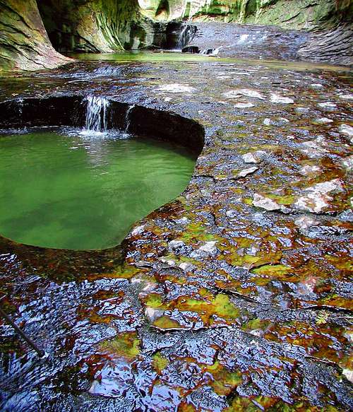
 Emerald Green Potholes and the Subway walls can be seen in this photo.
The Subway
Car Shuttle - From the south entrance of Zion National Park drive toward the small town of Virgin, looking for the Kolob Road sign. To locate the trailheads, turn on the Kolob Terrace Road in Virgin and drive until you see the trailhead signs. It will be about 8 miles to the Left Fork Trailhead and just over 15 miles to the Wildcat Canyon Trailhead. Park one car at the Lower Left Fork Trailhead and then continue north on the Kolob Terrace Road to the Wildcat Canyon Trailhead.
Commerical Shuttles
Zion Adventure Company: 435-772-1001
Zion Backcountry Trans: 435-772-7608
Zion Ponderosa: 800-293-5444
Zion Rock: 435-772-3303
Hiking - Begin hiking at the Wildcat Canyon Trailhead. The high plateau route (there is no formal trail) will take you through pine trees and an array wildflowers then the terrain changes to slickrock before you finally drop into the canyon.
The Canyon - Once at the canyon you will be required to climb down and over rocks and rappel into frigid water as you navigate the many obstacles that lie ahead. Don't miss the Subway Arch located above the Log in the Log Chamber and be sure to see the Waterfall Room. Both places are easy to miss. The water can be murky at times, but if your timing is good then it will be a clear, emerald green and your photos will be nice.
Cascades - Once out of the technical section there are beautiful cascades where water flows over layers of thin rock but most of all the warmth of the sun can finally be felt. Be cautious as the moss tends to make the rocks quite slippery.
Exit - Be sure to see the dinosaur tracks just prior to the exit. From the last rappel you will hike about 3 miles before you see the exit sign. It could be washed away or vandalized so be sure you know some exit landmarks just in case. If it is hot out, many hikers like to lay down in the river and cool off before they begin the mile long, steep slog up the mountainside to where their second vehicle is parked at the Lower Left Fork Trailhead.
Subway Topo Map
Zion Hiking Topo Map
Red Tape
 This corridor inspired the name: The Subway
The Photo: An undercut section of rock that forms a tubular design resembling a subway station has been dubbed the "Subway," but it is only part of the well known canyoneering route through the Left Fork of North Creek.
Entrance Fees and Permits for Zion National Park
Although there is not a booth along the Kolob Terrace Road a ranger will check for your park pass and your permit.
America the Beautiful Pass and Fees
$80 (annual) Pass to "all" public lands (Does not really seem to be all though, but it's a good pass to most things.)
Private Vehicle $25 (7 days)
Zion Park Pass $50 (annual)
Pedestrian/Bike $12 (7days)
Oversized Vehicle Fee (2 times /7days)
Backcountry Permit: $10
If you are bringing a camper or bigger into the main section of the park you need to know that there is a $15 (good for 2 trips in 7 days) escort fee for anything 7'10" wide and/or 11'4" tall or larger. You don't need to do this on the Kolob Terrace Road however.
Canyoneering Permits
Walk-in permits are limited and can be issued from the Zion Canyon Visitor Center the day of or the day before a canyoneering trip. If you canyoneer in Zion often, apply for an Express Permit which allows you to obtain a permit on-line. Permit Application
A backcountry permit is required from the National Park Service to hike The Subway.
The Subway is in the Primitive Zone which normally allows fifty visitors but due its popularity (social zone) 80 are now allowed. Some might hike in from the bottom and some from the top, some from Das Boot (Photo) or Russel Gulch, but the total allowed in is still the same. Group size is limited to a maximum of 12 people.
Camping
 The Log Chamber
Kolob Terrace
Nearby Free Camping
Mosquito Cove, located between mile markers 23 and 24 on the south side of Highway 9, south of Springdale. Also you can probably camp on the BLM land around Eagle Crags. In the Kolob Terrace free camping is often found at Smith Mesa.
Primitive Camping
There are 6 sites at Lava Point in the Kolob Terrace section. Due to winter road conditions the campground is usually only open from June to November.
Camping inside the Main Park
The Watchman Campground is near the south entrance of the park and is open year-round. Sites are given on a first come, first use basis November through March. Reservations can be made during the rest of the year. $16 per site without electric hookups, $18 per site with electric hookups, and $20 per site for river sites. Reservations: 877-444-6777
The South Campground is also located near the south entrance and is open March through October. All sites in the South Campground are first-come, first serve. $16 per site, per night.
Both of these campgrounds provide restrooms, picnic tables, RV dump, drinking water and utility sinks. There are no showers.
Backcountry Camping
For any backcountry camping you will need to apply for a permit at the visitor center and there is a fee. Groups must be 12 or less. Backpacking permits can be obtained up to three days before your trip date.
Gear and Safety
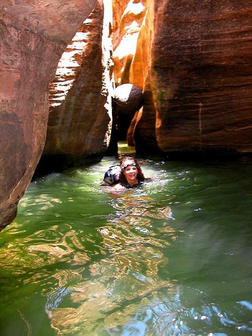 That's me in the CHILLY water of the Subway
Best Time to Go
Mid-June to mid-September when the water is warmer. Any other time of the year check to see what the water temperature is. You might need a wet/drysuit.
Gear - Bring a 60 foot rope, a dry bag, wear appropriate water shoes and quick dry clothing - not cotton. Do not hike the Subway during the cool months of the year unless you are experienced in winter canyoneering. Even in the shoulder seasons hikers have gotten into trouble and had to be rescued due to inappropriate clothing and gear. Never jump in these canyons! Use your rope and do not go unless you have some down-climbing skills.
Hi-Tech Clothing - The hi-tech shirts have probably become the most popular form of this type of clothing, often stocked in large department stores amidst regular clothing. The various types of hi-tech clothing are not only comfortable but they are light to wear and to carry so you can dress in layers and then toss into your pack what's not needed. The fabric wicks moisture away from skin and dries quickly which can be essential when hiking in cold weather. You will find the apparels quick dry properties essential in canyons such as the Subway where you are required to swim in shockingly icy cold pools and then when you get out its into the shaded chilly air of the canyon. Drying quickly can become essential.
Safety - The Subway looks like a water park to some, but jumping and horse-playing in the slot canyons can and has resulted in serious injuries. Check the weather before going. Never enter a slot canyon when it's raining at the location or upstream from where you will be hiking. Most canyons offer no refuge in the event of a flash flood. Do not think you can out run one or climb to safety. Sticky rubber shoes are essential for canyoneering. Carry enough water for the trip and wear quick dry clothing such as hi-tech shirts and shorts. Groups have had to be rescued from the Subway due to simple things like wearing cotton clothing that will not dry and then they are too cold to continue.
Remember - You are responsible for your own safety.
Informative Links
 The Subway
Informative links about The Subway and Zion National Park
National Park Service
The official NPS site is the place to read the rules, regulations, closures and current permit information.
Bo and Tanya's Subway information for the technical variation and the hike in from the bottom of the Left Fork of North Creek.
Shane Burrow's Information - Shane's Photo
Tom Jones Information
National Park Service
This is the Zion National Park section of the National Park Services official pages.
Back Country Guide - PDF File
East Zion Tourism Council
The East Zion Tourism Council covers the area from the east entrance of the park to Glendale.
Bo and Tanya's Zion National Park site.
Zion Food and Lodging
Food and Lodging - NPS Site Showers
Zion-area showers:
Tsunami Java & Juice - Springdale
Zion Rock & Mountain Guides -Springdale
Zion Area Map