
|
|
Mountain/Rock |
|---|---|
|
|
53.10350°N / 4.02864°W |
|
|
Gwynedd and Conwy |
|
|
Hiking, Mountaineering, Trad Climbing, Bouldering, Ice Climbing, Mixed, Scrambling |
|
|
Spring, Summer, Fall, Winter |
|
|
3284 ft / 1001 m |
|
|
Overview
| " To reach the Glyder Fawr, and pass by the edge of Klogwyn Dy Ymhen y Glyder, as dreadful a precipice as any in Snowdonia, hanging over the dire waters of Llyn Idwal… The prospect from this mountain is seen to great advantage; the deep vale of Llanberis and its lakes, Nant Francon, and a variety of other singular views. The plain which forms the top is strangely covered with loose stones like the beach of the sea; in many places crossing one another in all directions, and entirely naked… The elements seem to have warred against this mountain; rains have washed, lightnings torn, the very earth deserted and the winds made it the constant object of their fury."
Thomas Pennant - Tours in Wales (1810) |
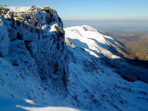
Glyder Fawr (1,001m) is the highest mountain in the Glyderau and the fifth highest in Snowdonia. The mountain is located on the main Glyder massif sitting between Glyder Fach (994m) and Y Garn (947m) and offers some magnificent views with Snowdon (1085m) to the south and Tryfan (917m) and the Carneddau to the north and northwest. Its summit is characterised by a series of highly weathered tors formed during the last ice age when the mountains upper slopes protruded above the ice as a nunatak. In Welsh its name means Big Mound, and when viewed from the south it would seem that the mountain lives up to this name, appearing to be no more than a large rounded rocky hill. However when viewed from the north it reveals so much more. Glyder Fawr is a climbers mountain, its northern slopes are flanked by a series of vertical cliffs and buttresses, which are teeming with both summer and winter routes. It also has a number of quality scrambling routes, and for those who don’t want to hang precariously from walls of rock, it has hiking routes too. In poor weather the ill-defined shape and rockiness of the mountain can make navigation a bit tricky, and the actual summit can be remarkably hard to find when the visibility is down to a few metres.
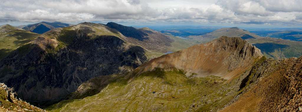
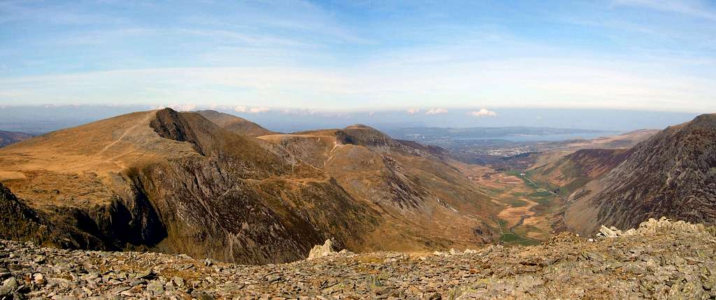
The Glyders from Clogwyn y Person, Snowdon. The mountains from left to right: Y Garn (947m), Pen-yr-Ole Wen (978m; background), Glyder Fawr (1,000m), Glyder Fach (994m), Crib Goch (923m) and Moel Siabod (872m; background)
(Photo by Nanuls)
(Photo by Nanuls)
Routes

This section attempts to summarise what Glyder Fawr has to offer the visiting mountaineer, be they aspirant or expert. In doing so, it will inevitably lean towards giving focus to what are thought to be the most popular or highest quality routes and in doing so, will sadly miss out on some of the less known, but fondly thought of lines. The author recommends therefore, that any reader planning to visit the Glyderau should also consider consulting one of the many high quality guidebooks that are available for the area, a perhaps less than comprehensive list of which, can be found in the Guidebooks section of this page.
Hiking
Almost all of Glyder Fawr is designated as Open Access Land under the auspices of the Countryside Rights of Way (CRoW) Act 2000. What this means for the hiker is that they can pretty much take what ever route they like to the top, whether there’s a path present or not. Most will not want to thrash through bog and bracken however, and will be more interested in taking one of the more conventional routes up the mountain. The section below provides details for the mountain’s most traveled paths, which all begin at clear, well established trailheads and are easily reached via public transport.
From Pen y Pass (approx 3km)
This short but steep route starts at the Pen y Pass carpark and ascends the mountain via a broad spur which passes Llyn Cwmffynnon to the north, before heading in a north/north-easterly direction itself, directly to the summit of the mountain.
From Gwastadnant (approx 4km)
This route begins deep in Llanberis Pass on the A4086 around halfway between Nant Peris and Ynys Ettws. It heads in a north-easterly direction up Cwm Cneifion (not to be confused with Cwm Cneifion which is on the northern side of the mountain), with the initial km being quite steep before easing and then terminating at a saddle which is home to a small pond called Llyn y Cwm. From here the path splits in four directions, with this route taking the southern path around the pond and ascends the steep and somewhat scrappy north-west face of Glyder Fawr.
Traverse of the Glyderau (approx 16km, more if you include Tryfan)
A classic route that crosses the entire Glyder range visiting the summits of Y Foel Goch, Glyder Fach, Glyder Fawr, Y Garn, Foel Goch and Elidir Fawr. There is also an option of nabbing Tryfan via its South Ridge if time permits. The route begins at Capel Curig in the east and roughly follows the main ‘hump’ of the range, finally terminating in Llanberis in the west. This leaves the walker with the logistical problem of finding their way back to their car, however thanks to the Snowdon Sherpa bus service, this is can be easily solved.
Scrambling
Glyder Fawr's numerous faces are home to many scrambles and low end technical climbs, only a few of which are listed below. Some of these routes can easily claim to be some of the best for their grade in the country and are extremely worthwhile objectives for anyone visiting the area. For full descriptions of most of these routes see Steve Ashton’s excellent guide, Scrambles in Snowdonia. The following section is not intended to be a comprehensive guide to the mountains scrambles, but more of a way of pointing the reader in the right direction.


Y Gribin (Grade 1)
The Y Gribin runs between Cwm Bochlwyd and Cwm Cneifion to join the main ridge that connects Glyder Fawr with its easterly neighbour Glyder Fach. The route is usually descended as part of the Cwm Bochlwyd horseshoe, but also provides a worthwhile easy ascent that incorporates, if you look for it, plenty of exposure.
False Cribin (Grade 1)
A variant of the Cribin Ridge route which, by careful route choice, can treble the amount of scrambling.
Cneifion Arête (Grade 3)
The Cneifion Arête is the most obvious ribbon or rock that rises out of Cwm Cneifion, a deep hanging valley that is nestled between the Cribin and Glyder Fawr. The initial 30m of ascent is more akin to rock climbing than scrambling, although it can be easily protected with a few sling runners. Although becoming more exposed, easier scrambling is found on the upper part of the arête which can be climbed in pitches, moving together or solo depending on conditions and the experience of the party.
Maybe Tower Rib (Grade 2/3)
To the right of the Cneifion Arête the Cribin flank of Cwm Cneifion curves round in an impressive shattered headwall containing much rock but few distinctive features. Though short and scruffy compared to Y Cribin and the Cneifion Arête, the rib has its moments and offers an enjoyable climb for the scrambling connoisseur.
Seniors’ Ridge (Grade 1)
Seniors’ Ridge is the blunt ridge that extends towards the summit of Glyder Fawr separating Cwm Cenfion from the much larger Cwm Idwal. Although its Cneifion Flank is short and unremarkable, its Idwal side is one of the most dramatic sites in Snowdonia. In summary it provides a devious approach to a broad uneventful ridge which provides some enjoyable scrambling in a grand setting.
Direct Approach to Seniors’ Ridge (Grade 2)
A more enjoyable line than the route above, provided through a contrived approach under the eat wall of the Idwal Slabs which provides a simple ridge scramble via a series of open gullies and short chimneys, culminating in an exposed breach of the retaining wall.
Idwal Staircase and Continuation (Grade 2)
The north-west face of Glyder Fawr rises from the shores of Llyn Idwal to its summit in a discontinuous series of slabs and buttresses. This route takes an uncharacteristic fault line in the lower section to gain rough slabs above the rock climbing territory on the lower left side of the face, thus gaining Seniors’ Ridge with considerably more style and only a little more difficulty than the two routes above.
North-West Face Route (Grade 2)
This routes provides an approach to Seniors’ Ridge which is more open, though less satisfying than the previous route. It takes the buttress located to the right of the Idwal Staircase then finds a way up rocky slopes in the centre of the face before joining Seniors’ Ridge below its final rise.
Bryant’s Gully (Grade 2)(Incorrectly identified in guidebook - see Additions & Corrections)
Esgair Felen (Yellow Ridge in Welsh), the southwest spur of Glyder Fawr, runs into Llanberis Pass as a huge triangular face of outcrop-covered scree slopes. Winding its way through the steep crags usually frequented by climbers is Bryant’s Gully which follows a shallow gully line which extends from the valley floor almost to the crest of the ridge.
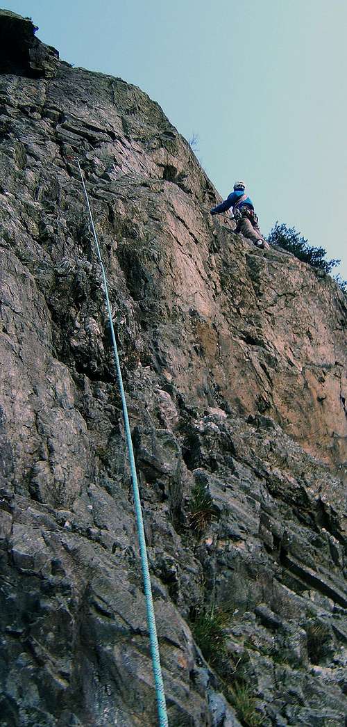
Rock Climbing

Glyder Fawr is among Snowdonia’s most popular mountains for climbers, although owing to the way in which guidebooks have been traditionally written, they will know the crags as either being in the Ogwen Valley or Llanberis Pass, the two large U-shaped valleys that run along the mountain’s northern and southern flanks. Crags on the northern side of the mountain are described in the Climbers’ Club’s Ogwen guide, while those in the south can be found in the Club’s Llanberis guide. Supplementing these detailed guides are a number of general guides, which will perhaps be more suitable for the occasional visitor; these are, in order of date published:
Rock Climbing in North Wales by Paul Williams (Constable)
North Wales Rock by Ground Up
North Wales Classics by Jack Geldard (Rockfax)
North Wales Climbs by Mark Reeves, Jack Geldard, Mark Glaister (Rockfax)
For those interested in such things, the first guidebook to North Wales rock, Rock Climbing in the British Isles, Volume 2 Wales and Ireland, was published way back in 1895 by W.P. Haskett Smith. This was followed by a more ‘modern’ incarnation of the guidebook in 1906 in the form of G.D. and A.P. Abraham’s Rock Climbing in North Wales. The first dedicated guide to climbing in the Ogwen Valley, Climbing in the Ogwen District, was written by J.M. Archer-Thompson and published by the Climbers’ Club’s in 1910. It was the Club’s second ever guide. A detailed guide describing crags in Llanberis Pass did not appear until after the First World War; A Climbers' Guide to Snowdon & the Beddgelert District by H.R.C. Carr was published by the Club in 1926.
The following section provides details of the mountain’s crags, first concentrating on the Ogwen crags and then moving onto the Llanberis ones.
As is the case throughout the UK, rock climbs on Glyder Fawr are graded using the combined adjectival and technical grading systems. To get an idea of what this means, Rockfax have a frankly excellent table plus explanation on their website.
Ogwen
Cwm Cneifion/The Nameless Cwm (SH 647 585)
This faintly inaccessible little cwm sits high on the eastern flank of Glyder Fawr, nestled between Y Cribin and Seniors Ridge. Its home to a variety of fine routes, graded Moderate to E8 6c, thereby having a bit of something to everyone. The Cwm is best known for having one of the finest mountaineering routes in Wales, the Cneifion Arête (Moderate), which given its grade, is a must do for all aspiring rock climbers. The route is usually preceded by an ascent of the Sub-Cneifion Rib (Very Difficult), a combination which provides an expedition all the way from the depths of Cwm Idwal and onto the airy ridge of Y Gribin.
Clogwyn Du (SH 646 583)
Located in the upper reaches of Cwm Cneifion, not far from Glyder Fawr’s summit, this cliff can claim to be one of Wales’ least accessible climbing grounds. Owing to a combination of a long walk in, poor drainage and its lack of sun, these cliffs receive little attention in summer, which is a pity as they contain two of the finest routes on the mountain, Manx Wall (HS) and Hebenwi (E2). The views from these crags is also stunning, sweeping down the Ogwen Valley and over the distant island of Anglesey.

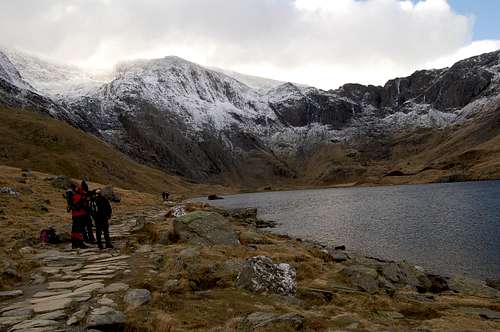
Idwal Slabs and Walls (SH 645 591)
Located on the far side of Llyn Idwal, this is one of the most popular climbing areas in Wales, offering routes of all grades including some of the hardest and most poorly protected pitches in the country. The crag consists of a large area of easy-angled overlapping slabs which rise to the foot of a steep wall. Atop of this stands the smaller Continuation Wall. The West Wall consists of a steep escarpment of slabs. The East Wall is a cliff of some 30-60m height which continues the same line as the Continuation Wall running parallel to it on the mountain side. Higher up the East Wall gives way to the Suicide Wall area, which boasts numerous fine routes, which weave their way up the sparsely protected rock face.
Clogwyn y Geifr (SH 639 589)
This cliff is made famous by the iconic dark cleft of Y Twll Du, or Devil’s Kitchen to the English, cutting its way through the centre of the crag. From the foot of this two synclinal terraces lead diagonally up, one to the left (South Syncline) and one to the right (North Syncline), further subdividing the cliff and providing a safe(ish) ascent or descent for anyone who needs it. The rock face below the South Syncline is known as the South Cliff and is a rather scruffy, damp, broken and mossy affair, while the crags below the North Syncline (known as the North Cliff, obviously) contains mush cleaner rock and is split into three by two gullies. Although the rock may seem unsuitable for climbing, it’s actually quite firm, although in places it can be friable, snapping under heavy usage.
Llanberis
Craig Ddu (SH 618 574)
This is the most westerly of the cliffs on the north side of Llanberis Pass, and despite its damp and unpleasant appearance, really is a lot better than it looks. That said, drainage from the steep slope above can mean that it takes a frustratingly long time to dry out and therefore, the climber really needs to pick their moment to visit. Due to the nature of the climbing on the crag, there is a greater element of seriousness to the routes than on other cliffs on the north side of the pass.
Clogwyn y Grochan (SH 622 573)
The Wrinkle
(Photo by Jans Man)
(Photo by Jans Man)
Clogwyn y Grochan is a popular crag located just a short walk up the valley from the aforementioned Craig Ddu. It is split into three buttresses that are spilt by two prominent gullies. The rock is steep, of exceptional quality and gives superb protection for the most part. It is sad therefore, that the upper section of the crag is slightly let down by an overabundance of vegetation. While there’s little for the low end climber here, those with more ability will find plenty to keep themselves happy. On the left most buttress, the trio of Phantom Rib (VS 4c), Nea (VS 4b) and Spectre (HVS 5a) provide a great day out for those climbing in the mid grades, while on the rightmost buttress provides another trio, Stroll On (E3 6a), Hangover (E1 5b) and Quasar (E3 6a), this time catering for the high end climber.
Carreg Wastad (SH 625 571)
The cliffs of Carreg Wastad can be found just opposite the Climbers’ Clun hut at Ynys Ettws, just a few hundred metres up the Pass from Clogwyn y Grochan. The crag is remarkably varied and provides a series of fluted slabs, chimneys, grooves, and overhangs, which are of mostly sound rock, which only gives way in places where it has an organ-pipe like structure. Routes span the grading spectrum and provide fun for low end to high end climber alike. Check out The Wrinkle (VD), Crackstone Rib (S 4a), Shadow Wall (VS 4c) and Erosion Groove Direct (E2 5c).
Dinas Cromlech (SH 629 569)
Dinas Cromlech is by far the most eminent and most evocative crag of Llanberis Pass. It stands starkly high on the mountain side above Pont y Cromlech, like some gargantuan and grim monolith. It’s steeped in climbing history, having enticed some of the most skilled climbers of the 20th Century to its steep and exposed rhyolite walls and pillars. John Menlove Edwards, Joe Brown, Don Whillans, Peter Livesey, Peter Harding and Ron Fawcett have all lavished attention on the crag and subsequently, it is home some of the finest top-grade climbing in Wales, plus several first-class easier routes, which are enhanced by their dramatic surroundings and situations.

For the low and mid grade climber, John Menlove Edward’s Dives/Better Things (HS 4b), Spiral Stairs (VD) and Flying Buttress (VD) are must do-es, in fact, the latter of these routes is considered to be the corner stone of any VD climber’s career. Joe Brown also made a contribution to these grades in the form of the superb Noah’s Warning (VS 5a) and finally E. and R. Williams’ mid grade classic, Sabre Cut (VS 4c), is also well worth a mention.
Needless to say, the extreme climber will also find much to enjoy here. Peter Harding was the first record such a line, when way back in 1947, he climbed Ivy Sepulchre (E1 5b). However, it would be Joe Brown who would really open things up, when alongside Don Whillans, climbed the now classic Cemetery Gates (E1 5b) in 1951. A year later, Brown returned and snatched the crag’s most enticing line, the soaring corner of Cenotaph Corner (E1 5c). It’s now considered a must for all E1 leaders. The 1970s bought a new generation of climbers to the crag, and resulted in the hard classics of Right Wall (E5 6a), Resurrection (E4 6a) and Ron Fawcett’s Lord of the Flies (E6 6a).
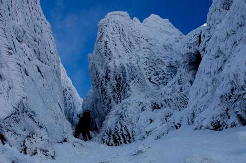
Winter Climbing
Unfortunately the close proximity of Glyder Fawr to the sea and the frequent arrival of Atlantic depressions pushing warm, moist air over the area, even in the middle of winter climbing conditions are infrequent and unreliable. Having said that, the last couple of winter’s (2009 and 2010) have been pretty damn good and if you’re lucky enough to be in the area when conditions are right, then the mountain offers one of the best winter climbing venues in Wales.
Winter routes in Snowdonia are graded using the Scottish Winter Grading system, which uses increasing Roman numerals to rate the difficulty of climbs. The system can be difficult to get to grips with for those unfamiliar with it, since it makes no distinction between snow ice, water ice and mixed routes, therefore when choosing a route, reading the description is critical.
There are currently three sources of route information for the Glyderau. These are, in order of date published:
Cicerone Guide: Welsh Winter Climbs by Malcolm Campbell and Andy NewtonWelsh Winter Climbs Wiki style siteGround Up Guide: North Wales Winter Climbing by Mark 'Baggy' Richards et al.


Cwm Cneifion (SH 647 583)
Cwm Cneifion, also known as the Nameless Cwm, is one of the highest cwms in Snowdonia and is consequently one of the most reliable for winter venues in the area. This makes it a very popular destination when conditions are forecast to be short-lived.
The Cwm has something for everyone. The easy-angled walls on its east facing side provide a number of moderate gullies and ice-falls. The best route in this part of the cwm is the Cneifion Arête (III), which offers 150 metres of sublime ‘easy’ mixed climbing.
Its west facing side offers something far more serious in the form of Clogwyn Du, which hosts a collection of quality routes at every grade between III and IX. There are frankly too many top-notch routes to list here, but those looking for the pick of the crop and have the ability may want to consider Cracking Up (IX, 9), Travesty (VIII, 5/6), El Mancho (VI, 7), Manx Wall (VI, 7) and Clogwyn Left Hand Branch (IV, 5). Those looking for something a bit easier, should look no further than the excellent Hidden Gully (II) on the far left flank of the crag. It’s worth baring in mind that the mixed routes on Clogwyn Du rely on frozen turf for them to be climbable at the given grade and, whilst very tempting, these routes should be avoided during the first few days of insulating snowfall that often comes with a period of winter conditions.
Cwm Cneifion (Photo by Nanuls)
Idwal Slabs (SH 645 589)
Better known for its summer rock climbing than its winter routes, Idwal Slabs does offer a handful of options for the winter climber. The routes in this area are often used as a more entertaining means of reaching Cwm Cneifion, the most popular being The Nameless Stream (III/IV) and East Wall Gully (I/II). It’s worth noting that these routes aren’t on the slabs themselves, in fact there’s only one true route on the slabs and that’s White Hope (III), which follows the drainage line the summer route of Charity (Severe 4b) avoids.
The Upper Cliff (SH 643 585)
As the name might suggest, the Upper Cliffs of Glyder Fawr, are well, quite high up on Glyder Fawr. There are few water ice routes here, so a good covering of snow is often required to make a trip worthwhile. Having said that, many of the lines are rich in vegetation, and so if cold conditions are in, routes can be climbed at a higher grade. The routes are arguably of a lower quality than those on Glyder Fawr’s winter climbing areas, however that doesn’t mean that they are entirely without worth; the classic summer route of Procrastination Cracks (Very Severe 5a) becomes an entertaining mixed Grade V, 6, while Grey Gully (II), Twisting Gully (III), East Gully (IV, 4), High Pasture (II) and Grass Route (IV, 4) are also worth a look.


Clogwyn y Geifr (SH 638 588)
Clogwyn y Geifr, also known as the Devil’s Kitchen, forms the imposing backwall to Cwm Idwal. Despite being the focus of Wales’ climbers for over 100 years, it has now fallen out of favour with the summer rock climber, but given the right winter conditions, it is transformed into what is arguably Wales’ premiere ice climbing venue.
Thanks to an abundance of perpetually seeping rock faces, complimented by a number of low-volume watercourses, the crag comes into condition with remarkable ease providing a variety of superb winter climbs. Stand out routes include the classic South Gully, the foreboding The Devil’s Kitchen (IV, 6) and the outrageous Devil’s Appendix (VI, 6), the latter of which is considered to be the real jewel in Idwal’s crown and is hopefully the most obvious feature in the cwm. Other popular ice climbs include The Ramp (III), The Screen (IV, 4), Devil’s Staircase (IV/V, 6) and The Devil’s Cellar (IV, 4).
Clogwyn y Geifr (Photo by Nanuls)
Bouldering
Bouldering on Glyder Fawr is very much focused around Llanberis Pass, with the Cromlech Boulders being its grand centrepiece, offering almost limitless problems for those who seek them. The quality and quantity of what’s on offer is so vast that the Pass has become well known to British climbers as one of the best bouldering venues in the country, and is consequently, extremely popular with those visiting the area. For those looking for something a bit quieter, the Ogwen Valley also offers some interest in the form of Clogwyn y Tarw and the highly accessible Idwal Cottage Crag.
Glyder Fawr is fortunate in having a growing number of excellent guidebooks that describe, in various degrees of detail, the bouldering problems on the mountain. For the climber who is more interested in trad and sport routes than bouldering, the Climbers’ Club’s Llanberis and Ogwen guides and Ground Up’s North Wales Rock have sections on bouldering, the former two being the better of the three because they provide much more detail. Those after something a bit more comprehensive should look no further than Simon Panton’s North Wales Bouldering / Bowldro Gogledd Cymru, an excellent bilingual guide that is entirely dedicated to the art of bouldering.
Cromlech Boulders (SH 629 566)

The Cromlech Boulders are often considered to be the jewel in the crown of Snowdonia bouldering. Easily the most accessible bouldering venue in Wales, it’s remarkable that they exist at all; for on the 6th of December 1973 they were within an hour or two of being blown up by the Gwynedd County Surveyor for road widening purposes. Luckily for us, locals, climbers, historians, conservationists, geologists and ordinary people from all over Britain, had been campaigning diligently for the boulders to be protected, and at the 11th hour they were saved through a direction from the then Secretary of State for Wales, Peter Thomas.
The scenery is outstanding and the problems, which range from V0- to V11 (Sub Society), are all superb, so its no surprise that they receive considerable attention from North Wales’ bouldering community, who often descend on the area after work and on weekends. Be sure to either get there very early or very late as parking could prove difficult; alternatively, you could just get the bus.
Other good bouldering spots nearby include Jerry’s Roof, which is home to one of the area’s hardest problem, Mr Fantastic (V12), Pont y Gromlech Slabs, which offer the outstanding The Seam (V3), the more limited Craig Llwyfan and The Barrel. The latter three venues are on the south side of the Pass, but their close proximity would make their exclusion something of an oversight.
Clogwyn y Tarw (SH 650 596)

Clogwyn y Tarw, which is also known as The Gribin Facet, is probably better known for its trad climbing than its bouldering, it is after all somewhat less accessible that the areas other venues. However, those willing to make the effort to drag their mats up to this ‘high altitude’ destination, will be rewarded with a complex boulder field that offers a number of superb short problems. Grades range from around, V0 to V9, however one will need to be more of an accomplished boulderer to get the most out of what’s offer. Raging Bull (V6), Red Sky Wall (V5) are probably the pick of the bunch.
Idwal Cottage Crag (SH 647 604)
Despite only being a short walk down the road from the popular car park at Idwal Cottage, this little crag is one of the area’s quietest. It’s home to a handful of problems, which range in difficulty from around V0- to V6, on good, if occasionally polished, rock, which is occasionally somewhat highball in nature. Fortunately, the landings are in general, pretty damn good. Stand at problems include Idwal Arête (V6) and Idwal Slab Central (V3) as well as the so far upgradeable subterranean struggle of Idwal Squeeze.
It’s worth mentioning, that further good bouldering can be found nearby around Tryfan and Caseg Ffraith.
Mountain Conditions
This section displays the mountain conditions for Snowdonia, of which Glyder Fawr is part. Click on the widget for maps and further information.
This Snowdonia weather forecast is generated by the Met Office Weather Widget
When To Climb
Glyder Fawr can be climbed at anytime of the year, however in poor conditions some routs are best avoided, particularly if visibility makes route finding difficult. Of course this all depends on ones ability as a mountaineer/climber, and what might be comfortable for some may seem daunting for others. It is worth noting that some areas of rock, particularly those that have been heavily abraded, can become very greasy when wet.
If your lucky enough to climb the mountain in winter conditions then an ice axe (or ice axes on the harder routes), crampons, a helmet, a rope and a decent winter rack (if going for a more serious route) are all essential.
Red Tape and Access
No red tape or access issues here!
For climbers, hill walkers and mountaineers, the British Mountaineering Council (BMC) runs a Regional Access Database, which holds mountain/crag specific information on matters of conservation and access, including issues such as nesting restrictions, nature designations and preferred parking:
If you are in any doubt about any particular access arrangement, or need to report an incident, you should contact your local BMC Access Representative or the BMC Access Officers for Wales: Elfyn Jones.
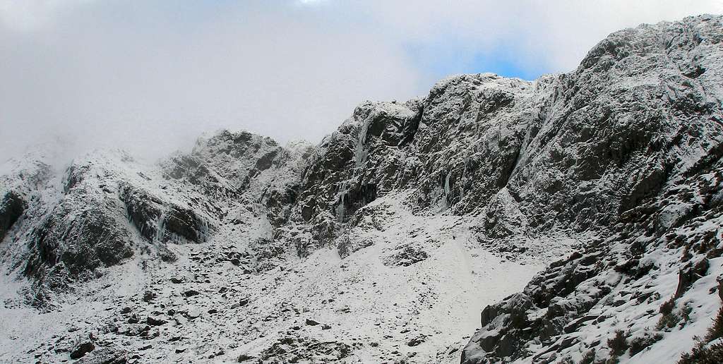
 Upper Clogwyn y Geift(Photo by Philip Staziw) Upper Clogwyn y Geift(Photo by Philip Staziw) |
 Bryant’s Gully(Photo by georgen) Bryant’s Gully(Photo by georgen) |
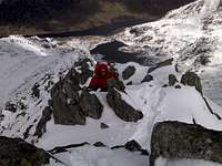
 The Summit (Photo by JoeHarris) The Summit (Photo by JoeHarris) |
Getting There
Conveniently, Glyder Fawr is located very close to both the A5 and the A486 meaning that there isn't a long approach to the bottom of the mountain, making it one of the most accessible mountain in Snowdonia.
If approaching from the north or west, e.g. from Liverpool or Hollyhead, turn off the A55 and onto the A5 at the large junction (SH 593 694) that sign posts for Bethesda and follow the road until Llyn Ogwen where parking is available.
If coming from the east, take the A5 through Bettws y Coed (SH 798 599) and Capel Curig (SH 719 580), which will take you directly to the base of the mountain.
If driving from the south, take the A470 through Blaenau Ffestiniog (SH 700 458) to Bettws y Coed, and turn off onto the A5 towards Bethesda, which will take you the same way as if coming from the east.
There is plenty of parking along the A5 near Glyder Fawr, some of which you have to pay for, some of which you don't. My advice is to never bother with the official car parks and just park along the roadside. There is a wide 'pavement' type verge on the southern side of the road that can easily accommodate the width of a car or minibus, and is completely free and never full (even on bank holidays). It also allows you to park even closer to the base of the mountain and the start of the path.
There is also parking to the south at Pen y Gwryd and Pen y Pass. The Pen y Pass car park (SH 647 555) is located at the zenith of the Pass of Llanberis, and can be reached easily by road on the A4086 that runs between Llanberis (SH 582 598) and Capel Curig (SH 719 580). Owing to the sheer number of routes that start there the Pen y Pass car park often fills up quickly so if you want to park there a very early start is recommended. There is also parking and a good starting point around 1.5km to the east along the roadside near the Pen-y-Gwryd Hotel (SH 660 558). Do not park in the hotels car park as this is for guests only.
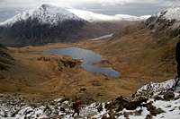
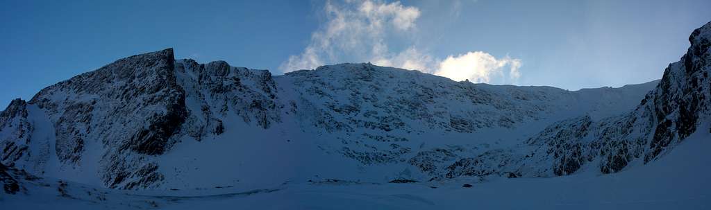
Y Garn and Nant Ffrancon, from Y Gribin, Glyder Fawr
(Photo by Nanuls)
(Photo by Nanuls)
Camping and Accommodation
There is plenty of camping in close proximity to Glyder Fawr: Gwern Gof Uchaf Campsite, Gwern Gôf Isaf Campsite and Bunkhouse and Garth Farm Campsite can all be found nearby just to the east.
There are also a number of YHA hostels in the area, the nearest of which is Idwal Cottage, a short walk from the base of the mountain. The Plas y Brenin National Mountain Centre in Capel Curig also has a bunk house, and has its own indoor climbing wall if you still feel energetic after your day on the mountain. Also the nearby towns of Capel Curig, Bettws y Coed and Bethesda all have various hotels, hostels, B&Bs and campsites.
Maps
Guidebooks
General
Snowdonia: The Official National Park Guide
Hiking
Cicerone Guide: The Mountains of England and Wales: Volume 1 Wales
Cicerone Guide: Hillwalking in Wales Vol 2
Cicerone Guide: Hillwalking in Snowdonia
Scrambling
Cicerone Guide: Ridges of Snowdonia (Also includes hiking routes)
Cicerone Guide: Scrambles in Snowdonia
Cicerone Guide: The Ridges of England, Wales and Ireland (Also includes rock climbs)
Northern Edge Books: North Wales Scrambles
Scrambles and Easy Climbs in Snowdonia (Also includes rock climbs)
Rock and Winter Climbing</p align="left"> Climbers' Club Guide to Wales: Ogwen (Also includes bouldering problems)
Ground Up Guide: North Wales Rock (Also includes bouldering problems)
Rockfax Guide: North Wales Classics (Also includes winter climbs)
Constable Guide: Rock Climbing in SnowdoniaThe Long Routes: Mountaineering Rock Climbs in Snowdonia and the Lake District
n-soul Guide: North Wales Bouldering/Bowldro Gogledd Cymru
Cicerone Guide: Welsh Winter Climbs
Ground Up Guide: North Wales Winter Climbing
Beta Sites
North Wales BoulderingRockfax Route Database
UKClimbing.com
Welsh Winter Climbs
External Links
Government Bodies and Official Organisations
Snowdonia National Park Authority
Association of National Park Authorities
Royal Commission on Ancient & Historical Monuments in Wales
Hiking, Climbing and Mountaineering Organisations and Companies
British Mountaineering Council
Plas y Brenin National Mountain Centre
Weather
Tourist Information
North Wales Tourism Partnership
Local Information from Gwynedd.com
Local Information from Snowdonia Wales Net
Travel
Welsh Public Transport Information
Accommodation
Youth Hostel Association in Wales
Maps and Guidebooks
Cordee Travel and Adventure Sports Bookshop
Wildlife and Conservation
georgen - May 14, 2009 2:07 pm - Voted 10/10
Bryants gullyAccording to new 2009 edition of Llanberis climbs/CC guides to Wales,ref.page 111/this name has been given to the wrong gully.The right Bryant`s gully is left of Clogwyn Y Grochan cliff.
Nanuls - May 17, 2009 4:27 am - Hasn't voted
Re: Bryants gullyCheers Georgen, I will check this out as soon next week. Dan