
|
|
Mountain/Rock |
|---|---|
|
|
28.96286°N / 90.27664°E |
|
|
Mountaineering |
|
|
Spring, Fall, Winter |
|
|
20033 ft / 6106 m |
|
|
Overview
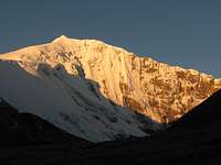
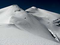
 Summit slopes of Naji Kangsha
Naji Kangsha (also called Naigyi Kangri) is an obscure 6000m peak hidden in a side valley near its imposing and almost homonymous neighbour Noijin Kangsang.
It belongs to the Lhagoi Kangri belt, a heteroclite juxtaposition of sub-ranges squeezed between the Yarlung Tsangpo (Brahmaputra) river to the north and the High Himalaya to the south.
Naji Kangsha (6'106m / 20'033ft) is one of the several little known snow-capped mountains over 6'000m located in the Karo La area, many of them still unclimbed.
The most logical route to climb Naji Kangsha is to follow the Nganyang valley before entering a side valley heading northeast. When you reach the Naji glacier, make a U-turn and continue southwards on the glacier or the adjacent rocky ridge.
This route is exempt of any serious difficulty, and the few crevasses on the glacier are easily identifiable and avoidable.
Prominence of Naji Kangsha is around 290m (950ft), with two saddles located at an equal elevation (approx. 5'820m) connecting with its higher neighbours to the north (Mt. Qigu, 6'212m) and to the south (Mt. Mengju Tsari, 6'110m).
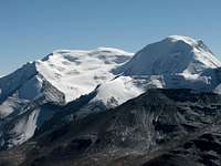
 Qigu (6212m, left) and Naji Kangsha (6106m,right) Qigu (6212m, left) and Naji Kangsha (6106m,right)seen from the northwest | 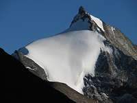 Mengju Zari (6110m) Mengju Zari (6110m)seen from the upper slopes of the Nganyang valley |
Mt. Naji Kangsha is a truly "hidden peak", as it is not visible from the bottom of the valley, and its summit appears only once you have reached the first slopes of the glacier. Thanks to its proximity to higher peaks (in particular Noijin Kangsang and Kaluxung), Nashi Kangsang represents an ideal target to acclimatize before attempting some more serious climbs.
Getting There
See Red Tape section for travel restrictions in Tibet.From mainland China to Tibet:
See the Noijin Kangsang page for a detailed description on the different routes into Tibet.
From Lhasa to the mountain
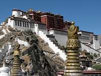 Lhasa LhasaPotala palace | 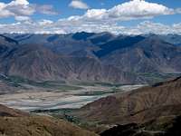 Yarlung Tsangpo Valley Yarlung Tsangpo ValleyFrom Gampa La | 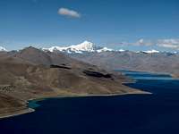 Panorama from Gampa La Panorama from Gampa LaYamdrok Yumtso with Noijin Kangsang |
Naji Kangsha is located around 185km south-west from Lhasa, near the main road between Nagartse and Gyantse. You can hire a vehicle in Lhasa (Landcruiser is not needed) or take a bus from Lhasa to Nagartse, and then from Nagartse to Gyantse.
The last stretch has been asphalted at the end of 2007, shortening the travel to about three to four hours. Leaving from Lhasa, the road first crosses Yarlung Tsangpo River (Brahmaputra), before climbing Gampa La (4800m), where there are fine views on Yamdrok Yumtso lake and the Karo La group in the background.
After passing the small town of Nagartse (several hotels and restaurants), continue further up towards Karo La (5'036m). 19 km after Nagartse, the Nganyang side valley will open to your right. Leave the main road at the turnoff and continue north for about 4-5km on a small motorable track. Stop at the end of the road (map P4879m) near the small Kangbu lamasery.
Approach via Shigatse
An approach from Shigatse through Gyantse is also possible, and is worth to be considered if you have just arrived in Lhasa and need a few more days for acclimation. In that case, stop 9km after Karo La on your way down to Nagartse.
 Shigatse ShigatseSecond largest town in Tibet, located around 165km west of Karo La | 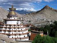 Gyantse GyantseWhere the road from Shigatse forks towards Karo La (east) and Sikkim (south) | 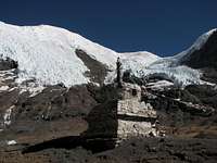 Kara Glacier Kara GlacierOn the south slopes of Noijing Kangsang just below Karo La (5036m) |
Red Tape
Regulations for entering and travelling within Tibet are changing rapidly, so check on travellers' websites for updated information.To enter and travel within Tibet:
Foreigners need the following documents to enter and travel within Tibet:
Tibet Entry Permit (issued by Tibet Tourism Bureau)
Tibet Entry Permit is usually requested when you buy a train or flight ticket. Local travel agencies in Beijing or Kathmandu can arrange in a few days your Tibet Entry Permit together with your train/plane ticket to Lhasa.
Alien Travel Permit (issued by Public Security Bureau – PSB)
Lhasa and Shigatse cities, as well as a few tourist spots around Lhasa have been declared open to foreigners, so that you don't need any additional permit anymore. However, as soon as you want to move into areas closed to foreigners, you need an Alien Travel Permit (ATP), which lists the places where you will be allowed to travel. Cost of an ATP is 50 RMB.
Climbing Permit (issue by China Tibet Mountaineering Association – CTMA)
Due to the current travel restrictions in Tibet, most peaks are usually proposed within a package including transportation and logistics by China Tibet Mountaineering Association (CTMA). The lump sum varies depending on the number of climbers, and bargain is possible depending on the service level you require.
Contact CTMA at the following address:
China Tibet Mountaineering Association
No 8 East Linkhor Road
Lhasa, Xizang/Tibet, China
Tel: +86-891- 6333687
fax:+ 86-891- 6336366
e-mail: ctma@public.ls.xz.cn
Camping and accommodation
Cheap hotels and restaurants can be found in Nagartse, 20km away from the peak. Camp sites along the route are described under Routes and difficulty.There are also plenty of nice trekking and camping possibilities around Karo La. Previous acclimation to the altitude is required!
When to climb
Spring (End of March till beginning of June) and autumn (End of September till beginning of November) are the best seasons to climb in the area. Winter climb is also possible, but you will need very warm equipment, as temperatures drop easily below 20°C at base camp altitude.Winds are usually stronger in spring than in autumn. Weather is instable during the summer rainy season (monsoon).
Routes and difficulty
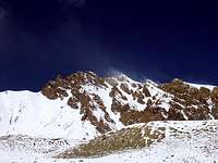
 1. Turn off 1. Turn offLooking SW towards Kaluxung at the entry of Nganyang valley |  2. Kangbu Monastery 2. Kangbu MonasterySmall monastery located below Kangbu Glacier lake |  3. Noijin Kangsang East Face 3. Noijin Kangsang East FaceSeen from P4879m at the end of the motorable track |
 4. Himalayan blue sheep 4. Himalayan blue sheep(Pseudois nayaur) Spotted at around 5’000m in the Nganyang valley |
At the turn off around 9km below Karo La (altitude 4720m), head north into the Nganyang valley for about 4-5km on a small motorable track until you reach the small Kangbu Lamasery (map P4879m), located near the perched Kangbu glacier lake (5124m). The site offers impressive view on Noijin Kangsang East face.
Follow the Nganyang valley upstream for another 2.5km, until you reach the next side valley draining the Qigu, Naji Kangsha and Mingju Zari glaciers. The confluent is marked as P5084m on the map. Head northeast into the narrow valley; your can either follow the river bed (frozen in winter), or walk at mid-height of the valley on a mix of scree with some patch of grass.
Camp sites are possible at around 5250m (flat grass section above the valley, GPS 28°57'18"N, 90°15'09"E), in the riverbed at 5340m (GPS 28°57'38"N, 90°15'31"E), or more conveniently higher up in the valley at about 5540m before the glacier (approx. 28°58'15"N, 90°16'2."E). Water is usually widely available from the river, but in winter you might have to melt ice unless you find some unfrozen resurgences.
 5. Nganyang valley 5. Nganyang valleyOn the frozen river during a winter trip |  6. Entering side valley 6. Entering side valleyHeading NE toward Naji Kangsha north Glacier |  7. Naji north glacier 7. Naji north glacierClimb on the glacier or follow the easy ridge |
 8. Summit slopes 8. Summit slopesSummit slopes from the north side, alt. 5800m |
From the camp site, wherever you have installed it in the valley, continue upwards to the NE until you reach the tongue of the Naji Kangsha north glacier at an altitude of about 5’600m. From this point, head to the south in the direction of the Naji Kangsha summit, which becomes visible for the first time.
You may chose to climb directly on the glacier (which might be difficult to access without technical climb in its lower part) or to follow the easy rocky ridge till approximately 5800m, where the glacier can be accessed easily on a relatively flat section.
The last 200m are slightly steeper, with a few crevasses easy to jump or to avoid. The upper part of the glacier may have a few section of blank ice toward the summit, especially in the late winter. The summit itself is a large rocky platform.
| 9. Reaching the summit… In the background, Yamdrok Yumtso lake |  10. The happiness to be on top! 10. The happiness to be on top!Summit jump at 6106m + 1m… |
Globally, the route will be rated with F difficulty grade (easy), but the combination of high altitude and strong wind make it still an interesting climb.
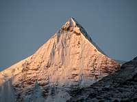
By clear weather (which was unfortunately not the case during our climb…), the summit of Naji Kangsha shall offer stunning views on Noijin Kangsang (7206m), Kaluxung (6674m), lower 6000ers in the area as well as scorpion-shaped Yamdrok Yumtso lake. To the east, the twin summit of unclimbed Yarla Shampo (6636m) should also be visible.
Panorama during Naji Kangsha climb
 Kaluxung (6674m) Kaluxung (6674m)emerging from the mist (alt. approx. 5700m) |  Noijin Kangsang Noijin KangsangEast Face (alt. approx. 5800m) |  Yamdrock Yumtso Yamdrock YumtsoSurreal vision (from the summit) |
Trekking and other climbs in the area
There are plenty beautiful trekking possibility around Karo La, as well as glacier climbs over 6'000m. See the Lhagoi Kangri area/range page for more information.The following peaks in the area have their own page on SP:
Maps
Google Earth is a precious tool to plan an expedition to the Lhagoi Kangri range, but the resolution of mountains east of longitude 91°14’ (Naji Kangsha is 91°16’) was not good at the time of writing this page.The Lhanzhou Institute of Glaciology and Geocryology has produced an excellent 1:50'000 map of Noijin Kangsang area, which includes Naji Kangsha and neighbouring peaks. The map is published by Xi’An Cartographic Publishing House (1997), and exists in both Chinese and English versions. Check here or here for order.
