
|
|
Route |
|---|---|
|
|
40.80072°N / 110.46182°W |
|
|
Hiking |
|
|
Summer, Fall |
|
|
A long day |
|
|
Class 3 |
|
|
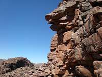
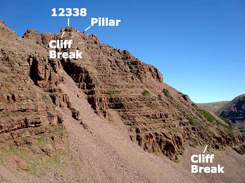 The south face of 12338
Overview
This page describes a route to Peak 12338, the northernmost peak of the Red Castle Ridge found in the Uinta mountains of Utah. Peak 12338 is remote, rugged, and sees few ascents. It looks intimidating, but there is a class 3 route with minimal exposure up its south face. From a distance it appears steep and composed of loose rock, but it's not so bad close up. It is not technically difficult, but is an interesting navigational challenge as small cliffs abound and you often do not get a view of where you are heading. When you do get to see ahead, it is not clear what is the summit until you are almost to it. Hmmm, should I angle left or right?
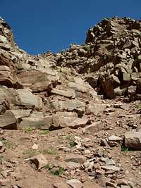 Some dirt Some dirtAll but .8 miles of the route are on an easy to follow, well maintained trail. There are no difficult creek crossings. The three major ones are bridged. Of the remaining .8 miles, .6 are either easy cross country travel or are standard boulder hopping. It is only .2 miles out of 11.8 that present any difficulty. But, in these .2 miles, you will climb 938 feet. The words loose and stable are subjective terms. There are loose rocks scattered all around, but it was always easy to choose a stable place to put my feet. I never felt like I was fighting gravity. The ascent is a mix of dirt with rocks sprinkled through it and 4-6' mini cliffs with tons of nice solid foot and hand holds. |
Stats
Start elevation: 9440 feetSummit elevation: 12338 feet
One way mileage: 11.8 miles
One way trail mileage: 11 miles
Elevation gained on trail: 1680 feet
One way off trail mileage: .8 miles
Elevation gained off trail: 1218 feet
Getting There
The route starts at the China Meadows Trailhead, located about 4 miles west of Henrys Fork, the major gateway to Kings Peak, the highpoint of Utah. For driving directions see the Getting There section for the main page.Route Description
Start from the China Meadows Trailhead. Follow the East Fork Smiths Fork Trail 9 miles to where it forks to bypass Red Castle. You will be in the woods most of the way and only gain 1300' in elevation during this stretch. The trail is well maintained, easy to follow, and has generally good footing.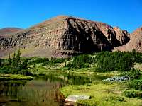 Heading to E Red Castle Lake Heading to E Red Castle Lake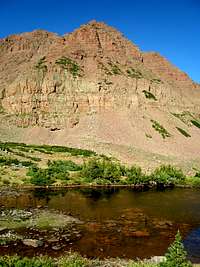 12388 12388At the 9 mile mark is a sign that points left for "E Red Castle Tr." and right for "Red Castle Tr.". You want to take the left fork and immediately cross a bridge. Go another 2 miles to a small stream at N40 47.997 W110 27.033. The East Red Castle Trail crosses the stream and continues to Smiths Fork Pass. Instead of doing this, make a right turn onto a small path just before the stream and head to the far end of East Red Castle Lake. The path fades out but it is easy cross country travel to the lake and around to the other side. There are several other small lakes in this vicinity. |
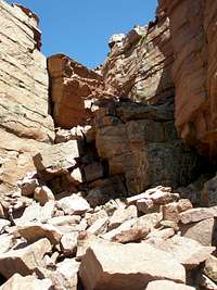
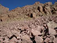 Heading to the cliff break Heading to the cliff break Cliff break Cliff breakThe base of 12338 is ringed with cliffs, but there is an obvious cliff break on the south side which is your immediate goal. Upon reaching the far end (west side) of East Red Castle Lake, work your way to this cliff break found at N40 47.916 W110 27.566. This section past the lake, is composed of annoying to walk on boulders. Note the cliffy sections on the right half of the left picture. Stay to the left/west of them on your way up. |
 11600': Angle left at top of cliff break 11600': Angle left at top of cliff break |  11920': Follow the grassy slope 11920': Follow the grassy slope | 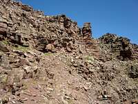 12100': Stay left/west of this area 12100': Stay left/west of this area | 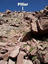 12160': Head for pillar 12160': Head for pillar |
With careful route finding, you can find your way to the top using only class 3 moves. However, you can make this as hard as you'd like and it would be easy to venture into class 5 territory if you wished. But, there are always lots of options and I never had any difficulty finding a way I was comfortable with.
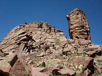 Summit and Pillar Summit and PillarI wound up just a little SE of the summit at the pillar shown at left. Directly ahead was an almost vertical wall (15' or so), with an obvious break which I'm sure some one could scramble up, but that some one is not me and I opted to find an easier way. |
 Traversing west Traversing west Looking back Looking backI traversed west at the base of the cliff towards Red Castle. The base is amazingly wide (10' or so) and is very comfortable to walk on. |
 Cliff break Cliff breakAt the southwest end of the summit block I found a very nice easy scrambling break that went to the summit ridge. |
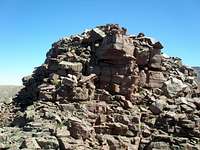 Last little bit Last little bit Looking back over the summit at 12700 Looking back over the summit at 12700Once past the break, the last little section is just an easy walk to the top. |
 Heading down Heading downTo return to the base, you might be successful if you just head down. However, the thought of getting stranded on a ledge overnight in below freezing temperatures was particularly unappealing to me, so on the way up, I set up some very small 3 stone cairns that I knocked over as I descended. Perhaps the cairns were overkill, but I was assured of not getting stuck. There were several sections that I would have sworn I did not come up were it not for seeing the 3 little rocks at their bottoms. Just as on the way up you can't see very far ahead to pick your route, it is the same going down. Although you can see stuff that is miles ahead, you can only see the ground ahead for a short distance so it's hard to pick a good way down. |
 Mt Powell Mt Powell |  north face of 12825 north face of 12825 |  12566 12566 |  12700 12700 |
Essential Gear
I wore a helmet, but other than that, just normal hiking gear is needed.Notes on GPS use
If you intend to rely on a GPS, you had better know what you are doing. Unless your GPS has a built in compass (most don't) you can't just follow the arrow when moving slowly and you will be moving slowly. GPS's work great at pinpointing locations on flatish terrain. They don't work so well when blocked by a steep slope. Reception may be spotty and the arrow will be jumping around. You need to observe where on the GPS's compass ring the arrow is pointing (e.g. NW) and head in that direction (i.e. go northwest) even if it is the opposite way from where the arrow is pointing.You should be able to use the waypoints as a rough guide, (e.g. is a waypoint to the left or right of you) but don't expect to pinpoint each location.
When to climb
In most years, mid June through the end of September will work. The mosquitoes go away by the end of August and the people pretty much clear out after Labor Day. On the day after Labor Day, a Tuesday, mine was the only car in the parking lot and I saw no one all day.Maps
 The trail part
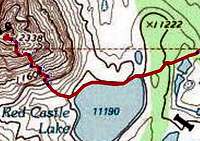 The off-trail part, blown up 300%