
|
|
Route |
|---|---|
|
|
36.66330°N / 114.8873°W |
|
|
scramble |
|
|
Most of a day |
|
|
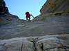
class 3 and 4 |
|
|
Approach
From the intersection of us95 and i15 in Vegas, drive about 21 miles NE on i15. At this point, us93 diverges from i15; take route 93 N for an additional 23.3 miles. Park your car well off the shoulder of route 93, near mile marker 75, to start the hike. The hike came to ~7.4 miles by GPS. This route is trailless, and would be fatally hot from May through October.Route Description
This hike is well-documented at Jim Boone's site, and the climber is referred there for an excellent description and pictures of the route.What follows is a brief description, in case Jim's site moves or the climber wishes to avoid the dryfalls.
Some waypoints, relative to WGS84, are given below:
36.692620, -114.894869, "mouth", "MOUTH", "MOUTH", ff0000, 47
36.691820, -114.888377, "fork", "FORK", "FORK", ff0000, 47
36.693353, -114.886365, "avoid-dryfall", "AVOID-DRYF", "AVOID-DRYFALL", ff0000, 47
36.693793, -114.884786, "cut-nnw", "CUT-NNW", "CUT-NNW", ff0000, 47
36.694084, -114.884913, "back-in-wash", "BACK-INWAS", "BACK-IN-WASH", ff0000, 47
36.695386, -114.884138, "enter-3rd", "ENTER-3RD", "ENTER-3RD", ff0000, 47
36.696401, -114.882409, "ridge-climb", "RIDG-CLIMB", "RIDGE-CLIMB", ff0000, 47
36.696761, -114.881392, "traverse-e", "TRAVERSE-E", "TRAVERSE-E", ff0000, 47
36.696430, -114.878961, "head-n", "HEAD-N", "HEAD-N", ff0000, 47
36.700065, -114.878637, "summit", "SUMMIT", "SUMMIT", ff0000, 47
This text above is in mxf format, and can be imported into many applications. The position of the waypoints is on a map at the bottom of this page.
From mile marker 75 on us93, head E and slightly N across the desert, to the waypoint labeled "mouth", which is the mouth of the canyon. Turn SE and eventually E and ascend the wash, till reaching the waypoint labeled "fork". Take the left (northern) fork. When you reach the point labeled "avoid-dryf" you have a choice; you can continue up the wash and climb the dryfalls, or you can cut right (S of the wash) and ascend the class 2 ridge to the point labeled "cut-nnw". If you take the latter option, upon reaching "cut-nnw", go to the north-facing edge of the ravine, and look for a class 2 descent back into the wash, travelling NNW. When you reach the point labeled "back-inwas", you are back in the wash (!!). Now you must work your way NE and NNE around small cliffs and chutes up the the point labeled "enter-3rd". Here you enter a 3rd-class, narrow chute for much elevation gain, still travelling NE and ENE. (The terrain is actually a bit confusing at the start of the chute; back up if your route seems to take you over unprotected cliffs, and try again.) The chute is full of loose rock, so you must manage your party to ensure safety. (If you are wondering why you took the perverse climb up to the 3rd-class chute, rather than continue up the main wash, here is the reason: the main wash soon comes to a towering, near-vertical quartzite cliff.) At the top of the chute, head for "ridg-climb", and travel NNE to the point labeled "traverse-e". Now traverse mainly east to a saddle on the ridge, labeled "head-n". Then head N to the "summit".
There is some debate about the summit location. The northern peaklet (in Jim Boone's parlance) is the point labeled as 5146T by the USGS. However, remember that the label is on a spot elevation checkpoint. Nowadays, spot elevations are usually not surveyed by traditional methods, and may serve mainly to check residuals in digital elevation models. Thus the spot elevations are on points that appear sharp on the aerial photos, not necessarily on summits. To my eye, the southern peaklet appeared higher, but it is blurry and indistinct on the aerial.
The dryfalls are fairly easy on ascent, but you may wish to avoid them on descent. The normally frictional limestone is smoother on the dryfalls, and would be treacherous if wet.
 |  |  |  |  |
Essential Gear
Bring plenty of water, regardless of the time of year. The rock is very frictional, but sticky rubber soles are useful for bouldering in the washes. Gloves may preserve your hands.At least 50' of 3/4" tubular webbing (2500 lb static) and a 10' sling and carabiners would be useful for belays. We didn't use anything, but with a bit of rain or route confusion, such faint safety measures might prove helpful. If you plan this hike for a short winter day, take a good headlamp.
A GPS can be useful, but will lose satellite lock in some of the deep canyons, so check the EPE (Garmin's "accuracy") constantly.
Miscellaneous Info
This route has been called class 4. Technically that rating may be correct, because some sections have enough exposure to kill you in a fall. The rock is very frictional, and feels like class 3, but don't be deceived; this is a little-climbed route, and has not been cleaned of loose rock. Particularly on the last "class 4" section on the summit block, be careful not to put all your weight on small protuberances. I believe you could avoid the last class 4 climb, simply by cutting E around the base of the block, then cutting back W.Update Feb-3-06: A friend just did the hike, and had this opinion of the class rating: The high elevation gully on the summit block is more like class 3. However, the lower big dryfall is definitely class 4 (or worse) and should be avoided.