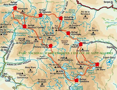
Intro
After having spent the last couple of summers in the Alps I decided it was finally time to try something else and since I had never gone to the Pyrenees, the choice wasn't that hard. After having surfed a bunch a SP-pages and having mailed with the highly productive SP members
Rafa Bartolome and
Eric Visentin I came up a with a schedule covering 3 weeks that included both a number of the highest peaks and crossed some of most beautiful areas. The schedule included two days in the
Aigüstortes - Sant Maurici National Park, an area that is recommended in all guide books and that Rafa and Visentin mentioned as well. It turned out that their recommendations were well founded, because the area is excellent for both hiking and scrambling to summits. This trip report is about my second day in the park - and trip that would take me to the summit of three major peaks in the eastern part of the national park.
Day 1 - rest day
Day 1 was scheduled as a rest day after having climbed Pica d'Estats (highest peak in Catalonia) the day before, and besides the weather was grey with a light drizzly in the morning. I was lazy and took a taxi jeep (5 euro) the 5 or so km's from the town of Espot up to the Sant Maurici reservoir and hiked 15 minutes to Refugi Ernest Mallefré, one of the smaller refugios on the highly popular
Carros de Foc circle trail.
![Carros de Foc route]() Carros de Foc route
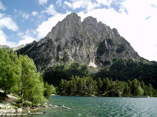
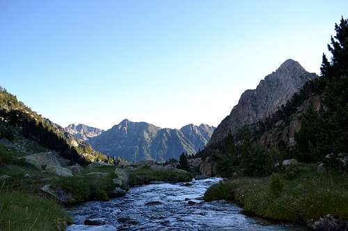
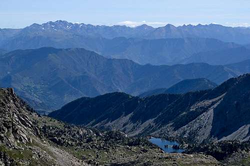
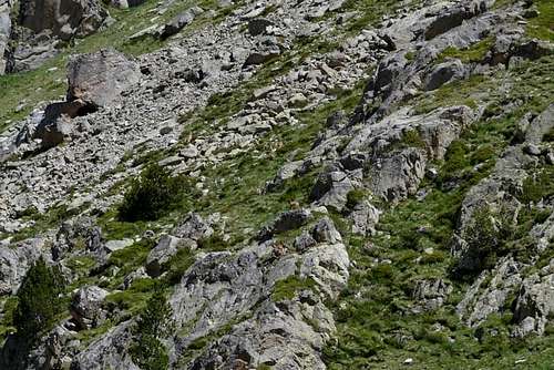
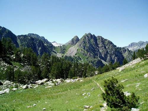
Carros de Foc routeI spent the afternoon hiking op to the Refugi d'Amitges. The cloud cover was located just a few hundred meters above the refugi, so there was no point in trying to climb a summit anyways. Instead I found a more or less abandoned trail on the way back to Ref. Mallafré that showed me some of the things the national parks is recommended for; lakes, crystal clear streams, water falls and some mountain goats to spice it all up! In the late afternoon the clouds lifted and the summits came into view. Especially the sight of
Els Encantats across the Sant Maurici reservoir was amazing. I had originally planned for day 2 to include climbs of
Pic de Perguera and
Pic de Monestero, but now I started thinking about if I could somehow add Els Encantats to the list, because the mountain looked like one of those you just
have to climb.
![Les Encantats]() Les Encantats seen across the Sant Maurici
Les Encantats seen across the Sant Maurici
reservoir
Day 2 - a long day ahead
The plan for day two had originally called from climbs of Pic. Perguera and Pic. Monestero, a trip mentioned as a full day outing in a hiking guide I had read. After having added Els Encantats it looked like it would be one of those marathon days, that I really enjoy (living in Copenhagen you really have to make the most of the days in the mountains, since Denmark overslept the day they were handing out mountains ...). Adding Els Encantats to the list also had the benefit that it would form a looped route and not just a trip out and back the same way.
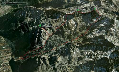
![GPS track of the route]() GPS track of the route. Pirineos 6.1 background map. A: Ref. Mallafré (1.893 m), B: Val. de Monestero, C: Coll de Peguera (2.718 m), D: Pic de Peguera (2.960 m), E: Coll de Monestero (2.715 m), F: Pic de Monestero (2.715 m), Coll de la Valleta Seca (2.722 m), Valleta Seca, I: Coll dels Encantats (2.582 m), J: Gran Encantats (2.748 m)
GPS track of the route. Pirineos 6.1 background map. A: Ref. Mallafré (1.893 m), B: Val. de Monestero, C: Coll de Peguera (2.718 m), D: Pic de Peguera (2.960 m), E: Coll de Monestero (2.715 m), F: Pic de Monestero (2.715 m), Coll de la Valleta Seca (2.722 m), Valleta Seca, I: Coll dels Encantats (2.582 m), J: Gran Encantats (2.748 m)For simplicity I'll split the trip into 4 stages:
Stage 1: Ref. Mallafré (A) - Pic. de Perguera (C)
Stage 2: Pic de Perguera (C) - Pic de Monestero (F)
Stage 3: Pic de Monestero (F) - Els Encantats (J)
Stage 4: Els Encantats (J) - Ref. Mallafré (A)
Stage 1: Ref. Mallafré - Pic. de Perguera
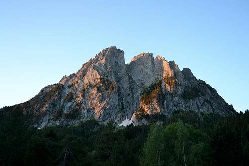
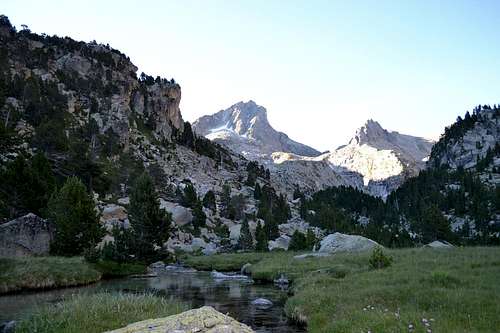
I knew, I had long day ahead of me, so got up at 6:40 to be ready for breakfast. Weather called for clear blue sky - excellent. Gulped the rather sparse breakfast (my ancient Viking genes cried for more food than the latino breakfast of dry bread, biscuits and a cup of coffee...) and was quickly on my way with alpenglow on Els Encantats and a deer with a fawn grassing. Pure idyll.
![Els Encantats in morning light]() Els Encantats in morning light
Els Encantats in morning lightThe first part of the route went up through the Monestero valley. The route followed the Carros del Foc route that connects nine refugios in the national park and is by far the most popular route in the park. Therefore it was a wide trail with board walks through all the swampy parts. Luxury. The weather and scenery was for taking post card shots, but sadly my camera couldn't do reality any justification
![Heading up through the Monestero valley]() Heading up through the Monestero valley
Heading up through the Monestero valley
![Looking back down the Monestero valley]() Looking back down the Monestero valley
Looking back down the Monestero valleyOne of the funniest moments of the day happened when I met a couple (Girlfriend and Boyfriend) that hiked in the opposite direction. They had camped further up the valley (I am not sure if that is allowed, but the chances of meeting a park official are close to none so...). They were a bit lost and asked me, where they were and if it was Pic de Peguera, we could see on the eastern side of the trail. I told them "ehh, no, Pic de Peguera is 2 km's back they way you came". Boyfriend didn't look convinced, so I found my GPS and showed him that we were standing in the middle of the Monestero valley. Boyfriend found it difficult to argue with technology, even though he still looked skeptical. It turned out that they had somehow missed hiking over the 100+ m high pass of Coll de Monestero in the fog the day before. As I left them, I could hear Girlfriend being quite sarcastic about the navigational skills of Boyfriend :)
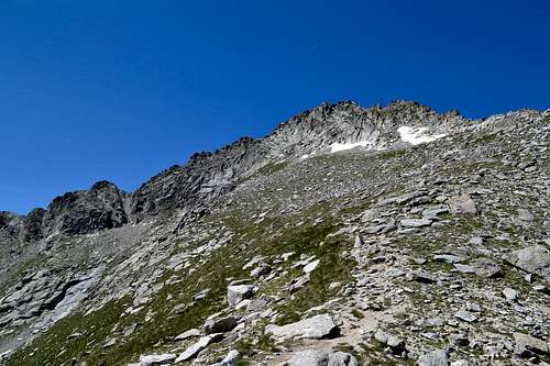
![First glimpse of Pic de Peguera]() First glimpse of Pic de Peguera
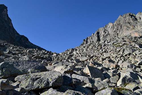
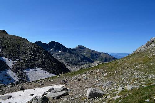
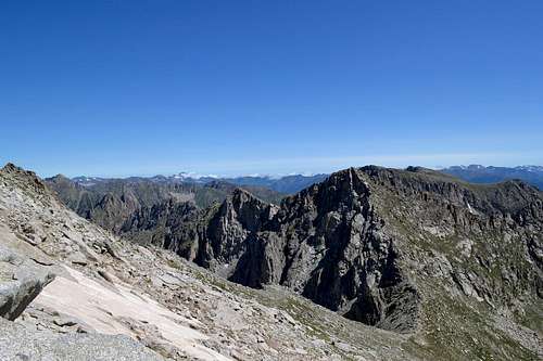
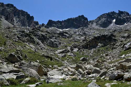
First glimpse of Pic de PegueraAround 2.500 m I left the main hiking trail that went to Coll de Monestero and followed a smaller trail that went to Coll de Peguera. The good and mostly level hiking trail was now replaced by boulder fields and snow fields. The latter were still frozen but starting to thaw so they were slippery as he**. I didn't bring crampons, so I had to bypass in the boulders or "elegantly" dance/slide across. The last section up to the pass went on soft gravel, three steps up, one step down. The view from the pass however were great. I could see the southern part of the national park, where the rather sharp ridges and peaks gave way to smaller and more rounded peaks
![Boulder field on the way to Coll de Peguera]() Boulder field on the way to Coll de Peguera
Boulder field on the way to Coll de Peguera![Panorama of the Monestero valley seen from Coll de Peguera]() Panorama of the Monestero valley seen from Coll de Peguera
Panorama of the Monestero valley seen from Coll de Peguera![View towards the southern part of the national park from Coll de Peguera]() View towards the southern part of the national park from Coll de Peguera
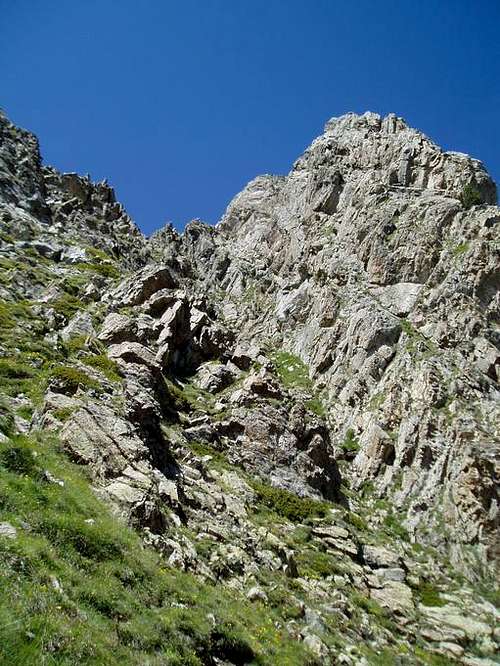
View towards the southern part of the national park from Coll de PegueraThe last 250 m of incline from the pass to the summit started out along a fine but steep hiking trail up the western face of the mountain before following the south ridge for the last 60 m.
![View back down on the boulder fields]() View back down on the boulder fields
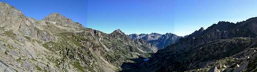
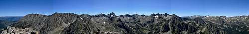
View back down on the boulder fields![Panorama taken from the trail heading up from the pass]() Panorama taken from the trail heading up from the pass
Panorama taken from the trail heading up from the passThe summit ridge consisted of big granite blocks and were on most places quite wide. In a few places on the last bit up to the summit it got more narrow, like a couple of meters, but with quite a drop on both sides, so concentration was high on this part. I caught up with a guy from Catalonia on this last part (I forgot his name, but
statistically he would be "Marc" - and thanks for sharing the climb!). He had taken the east face route up and we climbed the last part of the summit ridge together.
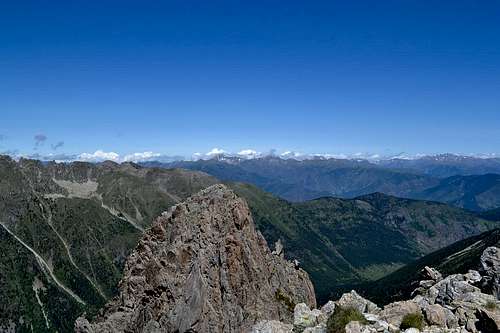
The view from the summit was grand! Hardly a cloud in the sky and the heat haze that had obscured the view a few days earlier was gone. We could see Pic d'Estats and Aneto and even the Montserrat massive which was located more than 80 km's away! And then with a few griffon vultures flying above us to spice it up even more
![View from the summit down into the Monestero valley]() View from the summit down into the Monestero valley
View from the summit down into the Monestero valley
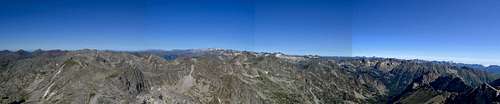
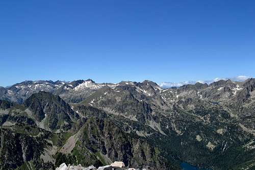
![Panorama from Pic de Peguera]() Panorama from Pic de Peguera
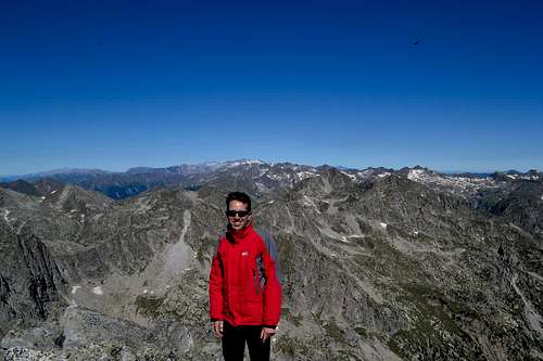
Panorama from Pic de Peguera![Me on the summit]() Me on the summit with the glaciers of the Aneto/Maladeta massive far
Me on the summit with the glaciers of the Aneto/Maladeta massive far
behind (30 km!).
Griffon vulture in the sky.
Stage 2: Pic de Perguera - Pic de Monestero
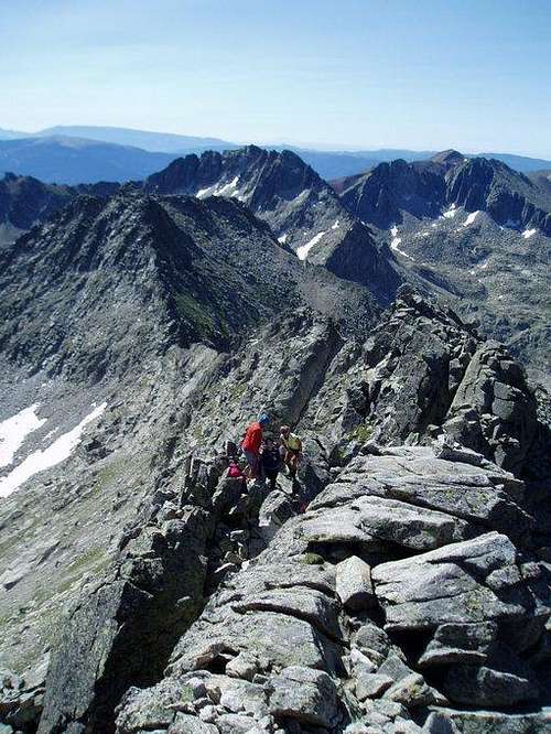
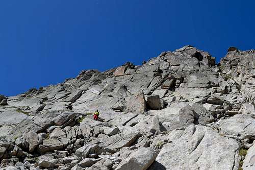
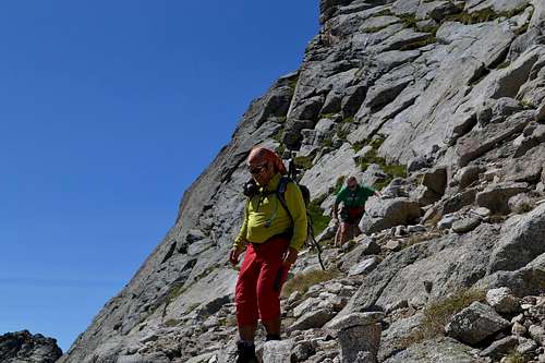
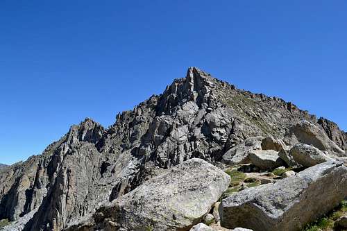
According to my map the route to the next pass, Coll de Monestero, should follow the northwest ridge. "Marc" however had been told by the wards of the nearby refugio, that it was prone to rock fall and that the east face route was better. "Marc" had climbed this way up and told me that it was fine. We retraced our route along the ridge, passed a group of Basque people, and then descended 20-25 m down a steep chimney.
This was the hardest part of the climb on Peguera. I used hands and feet on a few moves and didn't find it too difficult while "Marc" assisted the Basques with a rope that he had brought along.
![Summit ridge of Pic de Peguera]() The south ridge to the summit. A group of Basque
The south ridge to the summit. A group of Basque
people decided to skip the last section the summit but greeted us with
refreshments
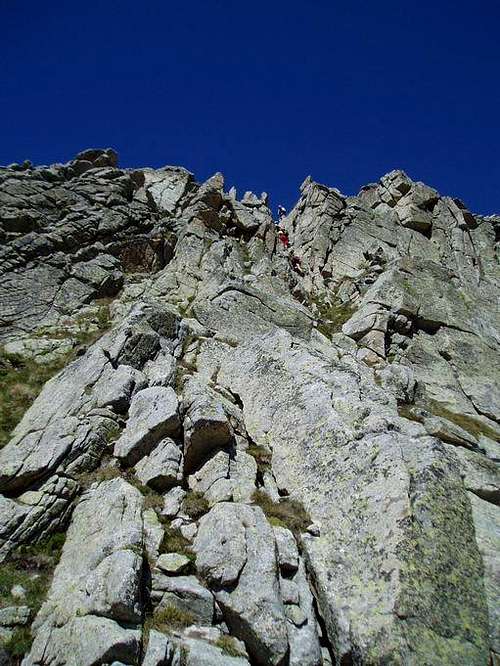
![Crux of eastern route to Pic de Peguera]() Descending the chimney on the east face of Pic de
Descending the chimney on the east face of Pic de
PegueraAt the foot of the chimney the route leveled out and followed ledges along smooth granite slabs for bit. Route finding was a little tricky but there were a few cairns here and there to guide the way. The last bit down to the pass went across grassy slopes.
![View towards the east with Pic d'Estats on the left]() View towards the east with Pic d'Estats on the left
View towards the east with Pic d'Estats on the left![Slabs on the eastern face of Pic de Peguera]() Slabs on the eastern face of Pic de Peguera
Slabs on the eastern face of Pic de Peguera
![Monestero seen from Peguera]() The last part of the descend from Peguera and Pic de
The last part of the descend from Peguera and Pic de
Monestero ahead
![Marc on the descend]() Marc on the descend
Marc on the descend![Peguera seen from Coll de Monestero]() Peguera seen from Coll de Monestero
Peguera seen from Coll de Monestero
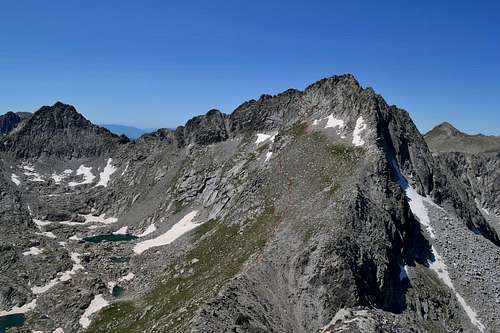
"Marc" wasn't going to Pic de Monestero, so we said goodbye in the pass. It was only 150 meters of climb from the pass to the summit, so it took no time getting up there, since there was an ok path most of the way. The view was again splendid, but it was getting really warm. It felt quite surreal to be sitting on a summit at 2.900 m in shorts and t-shirt with sweat pouring out.
![Monestero seen from the coll]() Monestero seen from the coll
Monestero seen from the coll![Pic de Peguera seen from the summit of Pic de Monestero]() Pic de Peguera seen from the summit of Pic de Monestero
Pic de Peguera seen from the summit of Pic de Monestero![View from Monestero]()
View from the summit of Pic de Monestero
towards the east
Stage 3: Pic de Monestero - Els Encantats
I descended Pic de Monestero on the northern side and headed towards the next pass, Coll de la Valleta Seca. It was more "off road" now, since there was hardly any trail left. Still the terrain was quite easy with a mixture of grass and a few rocks.
![Weird rock sculptures on the way down from Pic de Monestero]() Weird rock sculptures on the way down from Pic de Monestero
Weird rock sculptures on the way down from Pic de Monestero
![Panorama of Monestero]() Panorama of Pic de Monestero
Panorama of Pic de Monestero
taken from Coll de le Valleta Seca
![Valleta Seca seen from Coll de la Valleta Seca]() Valleta Seca seen from Coll de la Valleta Seca
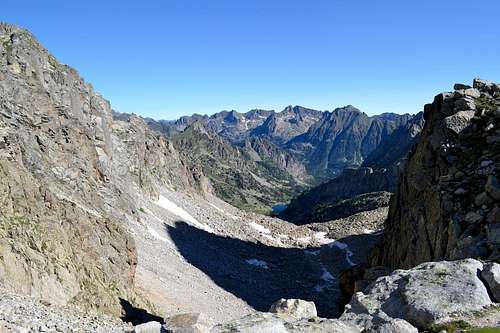
Valleta Seca seen from Coll de la Valleta SecaThe first part of the descend from Coll de la Valleta Seca consisted of loose gravel, so it was possible to "scree-surf" and get down quickly. As the slope leveled out, gravel was replaced by boulder fields and some easier sections. I only spotted a few cairns, but orientation was quite simple - just follow the valley. The scenery was really nice with a few small lakes, a group of chamois and a single fat marmot.
![Valleta Seca with Els Encantats towering on the right side of the valley]() Valleta Seca with Els Encantats towering on the right side of the valley
Valleta Seca with Els Encantats towering on the right side of the valley![Chamois in Valleta Seca]() Chamois in Valleta Seca
Chamois in Valleta Seca![View back up Valleta Seca]() View back up Valleta Seca. Coll de la Valleta Seca is the
View back up Valleta Seca. Coll de la Valleta Seca is the
pass on the leftAs I got down to approx. 2.300 m I reached a trail intersection. I could either head directly down to the refugio (my legs voted for that) or since it was only 2 pm and weather was still fine, I could take the path to the right and climb Gran Encantats (my head voted for that) - so Gran Encantats it was. I stashed some stuff I didn't need to save weight and headed uphill.
Shortly after the intersection I met two Germans. They had been heading for the summit but had turned back in the ravine leading towards Coll dels Encantats due to risk if rock fall. They had however seen another climber continuing to the summit, so I decided to have a look at it.
![Gran Encantats seen from Coll els Encantats]() Gran Encantats seen from Coll els Encantats
Gran Encantats seen from Coll els Encantats
The first 300 meters of climbing went up through a small ravine to Coll dels Encantats. The surface was a mixture of loose gravel and loose rocks and a few sections with more stable rock formation. Mostly however it was just two steps up and one step down. Crappy terrain. From the coll the terrain got even steeper, but on the good side the loose stuff was replaced by more competent limestone. Most of the way it was simple scrambling with hands only used for a little support. On 3-4 sections however it was much steeper and more like low grade climbing. It wasn't technically that difficult and the rocks were good, but the consequences of a fall would have been fatal - what a cross and memorial plate shortly before the summit clearly shoved. I got to the summit 45 minutes after leaving the intersection with a high pulse due to a mixture of a speedy accent and
adrenaline of the climb
![Petit Encantat seen from Gran Encantat]() Petit Encantat seen from Gran Encantat
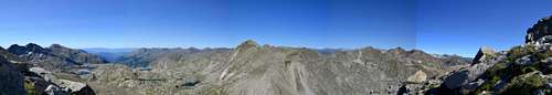
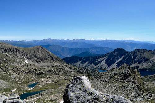
Petit Encantat seen from Gran Encantat![Panorama seen from Gran Encantat]() Panorama taken from the summit of Gran Encantat
Panorama taken from the summit of Gran Encantat
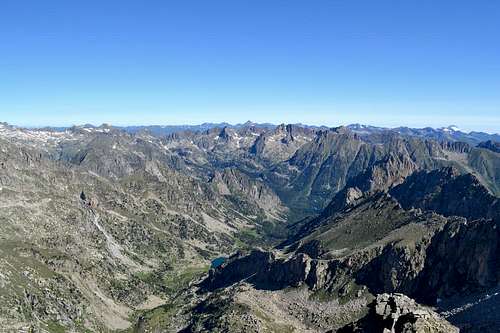
![View northwest from Gran Encantat]() View from the summit of Gran
View from the summit of Gran
Encantat with the Sant Maurici reservoir down to the right
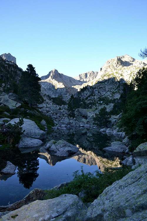
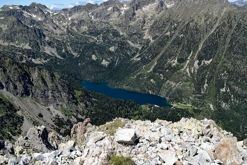
![Estany de Sant Maurici]() Estany de Sant Maurici seen from
Estany de Sant Maurici seen from
the summit of Gran Encantat
Stage 4: Els Encantats - Ref. Mallafré
I drank the last of the water I had brought along, gathered a little strength and then started the climb down. My concentration was really high on the first climbing sections, but from the coll down it got easier - although the terrain was almost as crappy going down as coming up, since 80% of the rocks you touched started sliding down the ravine.
I got the to intersection, picked up my stashed stuff and headed back towards the refugio. There was a good hiking trail on this last section, and my legs were happy for finally seeing some easy terrain.
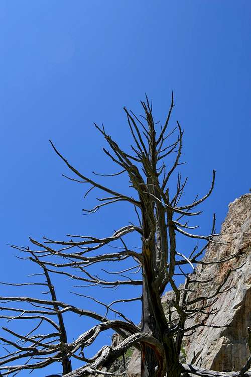
![Picturesque dead trees on the descend from Gran Encantat]() Picturesque dead trees on the descend from Gran Encantat
Picturesque dead trees on the descend from Gran Encantat
![Easy trail the last part of the way down]() Easy trail the last part of the way down
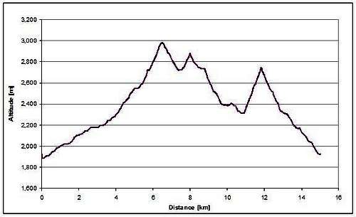
Easy trail the last part of the way downI got back to the refugio around 4 pm after just short of 9 hours of hiking/scrambling/climbing. According to the GPS I had climbed 2.000 m in just 15 km. No wonder my legs were getting tired. Average speed was a poor 2.7 km/h which tells a little about this trip being not just another day at the office.
I celebrated the climb and a perfect day in the mountains with a beer and then just spent the rest of the afternoon relaxing on the porch of the refugio. Later in my 3 weeks trip I would come back to the national park to climb Gran Tuc de Colomers and Pic de Comalforno - and the national park is also on the list of places I'd really like to revised in the future, since for me it has the optimal difficulty for scrambling.
![Google Earth illustration of the route]() Google Earth illustration of the route
Google Earth illustration of the route![GPS elevation data of the route]() GPS elevation data of the route
GPS elevation data of the route
Comments
No comments posted yet.