
-
 1184 Hits
-
 76.66% Score
-
 7 Votes
|
|
Route |
|---|---|
|
|
46.51143°N / 14.75024°E |
|
|
Download GPX » View Route on Map |
|
|
Hiking |
|
|
Summer, Fall |
|
|
Half a day |
|
|
T4/T3 by the Swiss Hiking Scale |
|
|
Introduction
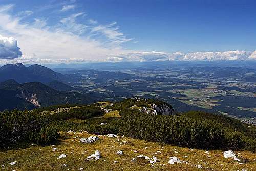
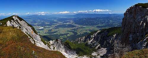 The eastern panorama from the NW ridge
Only some routes on the broad summit massif of Peca/Petzen are more attractive, but as there are many of them, you can do some interesting combinations. Also the western route is quite a boring one, at least in summer conditions. But here I'm describing a round tour, a rarely done combination with the return by a hunters path, which is almost nowhere described. Not being aware of it, it saved my day and assured a decent return to the trailhead.
Overview
We'll do a quick ascent by the normal west approach - from Luža alpine meadow (Luschaalm). It's easy and more attractive is only the very summit part, bringing you on the Feistritzer Spitze / Bistriška špica. The descent will go by the nice and panoramic northwestern ridge. When reaching the Wackendorfer Alm / Veška planina, you must deter sharp left and on the meadow edge find the hunters path. This one is narrow, at least medium difficult and crosses the steep, rocky and forrested slopes towards the south. You'll have to carefully walk and even scramble a bit some 2 hours, to reach the trailhead again.
General Information
Difficulty: The first two parts are an easy hiking tour. The hunters path is narrow, very weak, only scarcely marked and requires full attention. A few places are exposed and only some (not all) provisionally protected by a slim cable. On the Swiss Hiking Scale its difficulty is graded as a constant T3, with details of T4.
Orientation: The hunters path is very weakly marked (washed, old red and white dots). You constantly need to be attentive to stay on the trail. Especially on some steep places in the woods it's not clear where the weak trail goes.
Exposition: On many places the hunters path goes over steep forrested slopes, where you shouldn't slip. But some passages are also open and exposed (short rock walls below the path).
Objective dangers: Nothing special. In the woods with many crags, there's a certain danger of rockfall.
Best season: Summer months, normally from June till the first snow.
Gear: Good shoes and poles are sufficient.
Tour start: Planina Luža / Luschaalm (alpine meadow), 1287 m. By the road barrier there's a lot of parking space.
Highest point: Bistriška špica / Feistritzer Spitze, 2114 m. (Or, you can continure for more that 1 h 30 minutes on the highest summit of Peca/Petzen, 2126 m.
Altitude to overcome: cca 900 m (with small ups and downs on the hunters path).
Time for the whole round tour: 6 h.
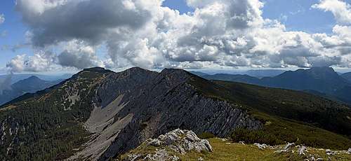 The summit ridge of Peca/Petzen from Bistriška špica / Feistritzer Spitze
Route Points
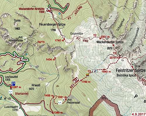
See the GPX track in the header!
Ascent:
1287 m - Parking place on Luschaalm / Luža. 1380 m - From the road above Luža turn left (N). 1455 m - Reach the road and leave it. 1591 m - Petzenstall (hut, meadow, view, road). Leave the road. 1760 m - Clearing in the wood. Another one on 1786 m. 1940 m - Timberline, the summit shows through dwarf pines. 2070 m - Crossing near the main ridge - go right (E). 2114 m - Bistriška špica / Feistritzer Spitze summit.
Descent:
2114 m - Bistriška špica / Feistritzer Spitze summit. 2070 m - Crossing, continue by the main ridge (NW). 2079 m - Wachendorfer Spitze - Veška kopa summit. 2001 m - Hunters post (keep left, by marks). 1740 m - Road end, water source. 1568 m - Wachendorfer Alm / Veška planina, turn left (S-SW). 1434 m - Hunters post, reach the road end. 1455 m - Leave the road deterring right (SW). 1380 m - Hit the road again. 1287 m - Parking place.
Route Description
Ascent
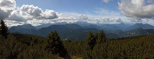 Western panorama
From the parking place you continue by the road to the meadow and there keep left. Follow the road eastwards, also on the big turn right. Only on 1380 m turn left on a broad marked path. Then follow the marks all the time through the woods. As seen above you twice cross the road, then continue in the NE direction. Only above 1940 m the terrain clears a bit, completely only on the main ridge, which you follow right on top. This route is very nice as a ski tour. It's easy and can be done also in hard winter (as long as the road to Luschaalm / Luža, or at least through the valley of Leppen/Lepena to Riepl) is cleaned.
Descent
 Descending by the NW ridge of Bistriška špica / Feistritzer Spitze
You return towards the NW to the crossroads and continue in the same direction along the main ridge. Also the summit of Wachendorfer Spitze - Veška kopa offers a nice panorama. From it the descent goes close to the main ridge till some 2000 m. By a hunters post (Mlake, occasionally a small pond) you keep left, stick to the marks and continue descending by open, grassy slopes. You pass another hunters post and in a small valley reach the road end and a water source. Then continue by the marked path (the road goes much around) towards the N-NW on Wachendorfer Alm / Veška planina (meadow, huts, chapel). At the house near the chapel you must turn left and at the end of the meadow find the hunters path. Stick to it and its rare white and red marks all the time. First it crosses steep woods, then it passes a few crags and crosses deep ravines. You gain distance only slowly. Soon rock crags are below and above you. The path winds by best passages, some are exposed. Towards the end two places are even a bit protected by cable, I guess on one place the cable is already missing. Finally on a clearing you reach a broad, open slope where branches and rocks are covering the path completely. Spot the hunters post above and when you reach it, you'll also hit the end of a broad forrest road. Then just follow it towards the south. You'll get on the point 1455 m, unless some 15 minutes before you find an unmarked shortcut right. That one can bring you on Luschaalm / Luža directly. Dilemma. To me, one more question remains unsolved. On the hunters path, after you pass the first rocky crags, there should be a trail branching (see the map, in the past there was a plate on a tree). In that area the path was very weak and I was happy to find it - keeping left. So, it's possible that one path goes there also further down, to the hunters hut (Wieselhuette) and even down on the road. That would not be a bad return option either.