Big Sur Peakbagging
-

gordonye - Posts: 2504
- Joined: Tue Aug 14, 2001 9:55 am
- Thanked: 1 time in 1 post
Re: Big Sur Peakbagging
I drove my passenger car to Chews Ridge some years ago. The road (unpaved) continues to the Tassajara Springs Zen buddhist monastery. Yes I saw the weather station at Chews Ridge too. The summit area was quite flat and full of trees. Has the recent fire opened up the view?
-

mconnell - Posts: 7494
- Joined: Tue Jul 03, 2001 4:28 pm
- Thanked: 338 times in 201 posts
Re: Big Sur Peakbagging
NEVER MIND!
(This post used to say some confused rantings.)
(This post used to say some confused rantings.)
-

Bob Burd - Forum Moderator
- Posts: 4271
- Joined: Sun Jul 22, 2001 10:42 pm
- Thanked: 572 times in 296 posts
Re: Big Sur Peakbagging
<i>snwburds 'ridge' from VC to South VC is an hullicination brought on by dehydration. It's probably doable but the ridge I was looking at from VC doesn't go all the way across, forcing you to drop all the way down. It would be an ugly trip. Sounds like fun!</I>
Let's see who's doing drugs here: said ridge from VC to SVC is in fact the same route mconnell travelled with me a few months ago. Can it still be a hallucination?
I think mconnell was referring to the VC to DVC route, but I don't think Chris was contemplating that one. However, I have done further research on this and have concluded that it is in fact possible. The part that looks most difficult (close to DVC) can be bypassed by dropping down a short distance on the west side of the ridge, and has been done by others. I'm going to consider this route next spring if anyone is interested. Mark, you can come if you promise to stop with the drugs.
-
Bob Burd - Forum Moderator
- Posts: 4271
- Joined: Sun Jul 22, 2001 10:42 pm
- Thanked: 572 times in 296 posts
Re: Big Sur Peakbagging
Whew, took a while to dig this one back out of the archives. You may recall that one Kelsey Jordahl and friend beat mconnell and I to the summit of Ventana Cone by three days, leaving us this note:
<p>
<a href=http://www.snwburd.com/bob/trip_photos/ventana_cone/reg/DSC00043.jpg><img src=http://www.snwburd.com/bob/trip_photos/ventana_cone/thm/DSC00043.jpg></a>
<p>
Fast-forward four months and shift to Disaster Peak somewhere north of Sonora Pass. <a href=http://www.snwburd.com/bob/sp/disaster_8_25_02.jpg>This time</a>, Kelsey didn't get there before me. Ha!
<p>
<a href=http://www.snwburd.com/bob/trip_photos/ventana_cone/reg/DSC00043.jpg><img src=http://www.snwburd.com/bob/trip_photos/ventana_cone/thm/DSC00043.jpg></a>
<p>
Fast-forward four months and shift to Disaster Peak somewhere north of Sonora Pass. <a href=http://www.snwburd.com/bob/sp/disaster_8_25_02.jpg>This time</a>, Kelsey didn't get there before me. Ha!
-
Bob Burd - Forum Moderator
- Posts: 4271
- Joined: Sun Jul 22, 2001 10:42 pm
- Thanked: 572 times in 296 posts
I dug this out mostly for Mark. He was with me on the first trip we made to Ventana Double Cone. It's been wondered over the years whether one could successfully negotiate the ridge to Ventana Double Cone and get back in the same day. We weren't successful in attempts in 2003 and again in 2004. A few weeks ago Michael Graupe and I finally completed the grueling <a href=http://www.snwburd.com/bob/trip_reports/south_ventana_cone_4.html>Ventana Triple Crown</a>. I'm done with the Ventana for this year, thank you.
-
Bob Burd - Forum Moderator
- Posts: 4271
- Joined: Sun Jul 22, 2001 10:42 pm
- Thanked: 572 times in 296 posts
Adam T wrote:Has anyone heard of /climbed Kandlebinder, near the VDC? Theres a little known shortcut that leads to it, involving some bushwacking that I would love to do.
If anyone still wants to do some hiking in the area, feel free to email me, wachteladam@hotmail.com
Kandlbinder is another toughie that Matthew and I failed on the first effort (we got lost in the maze of the Little Sur drainage). I'd definitely be up for trying that again. But not until next winter/spring. Too many flies out now. I'm not sure what shortcut you could be referring to, because that peak is as remote as Ventana Double Cone - only without the trail leading to the summit.
-

puma_patrick - Posts: 11
- Joined: Wed May 28, 2003 12:43 pm
- Thanked: 0 time in 0 post
Post Summit/Andrew Molera
Hiked Post Summit on July 11th, The trail is in great shape from the fire last year, steep and rocky on the fire break the to the top. Some of the best views along the coast. 3500 feet may not sound like much, but this trail is a workout.

-
puma_patrick - Posts: 11
- Joined: Wed May 28, 2003 12:43 pm
- Thanked: 0 time in 0 post
This trail is hot, dry and in the open in grass meadows, few flys and no problem with poison oak. Very few people hike this trail. Hope this helps.....pjc
The trip took me "forever" I spent 7hours out there........anyone else have their times for the roundtrip?
The trip took me "forever" I spent 7hours out there........anyone else have their times for the roundtrip?
Last edited by puma_patrick on Thu Jul 23, 2009 4:07 pm, edited 1 time in total.
-
Bob Burd - Forum Moderator
- Posts: 4271
- Joined: Sun Jul 22, 2001 10:42 pm
- Thanked: 572 times in 296 posts
rhyang wrote:I wonder what Kandlbinder will be like after the fires ..
I've been wondering that too. Matthew and I tried to reach it via Mt. Manuel one year, thinking it looked good on the topo, but finding totally impenatrable brush in practice. Might make a reasonable route...
-

fedak - Posts: 710
- Joined: Tue Jun 24, 2003 5:28 pm
- Thanked: 106 times in 85 posts
From every report I've seen, most of these routes are now open.
Pinyon is supposedly now more or less a walkup and there was a guy on the VWA forum who reportedly did the Manuel > VDC traverse (though I couldn't make heads or tails of his trip report)
Couldn't pay me to be down there between Memorial and Labor day tho
Pinyon is supposedly now more or less a walkup and there was a guy on the VWA forum who reportedly did the Manuel > VDC traverse (though I couldn't make heads or tails of his trip report)
Couldn't pay me to be down there between Memorial and Labor day tho
-

rhyang - Posts: 8960
- Joined: Wed Apr 28, 2004 8:55 pm
- Thanked: 59 times in 38 posts
Headed in to do Ventana Cone this weekend. Saw a lot of stuff like this on the ridge -
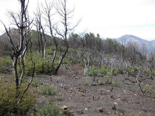
I suspect this made it a bit easier than some past attempts, but never fear, there is plenty of nice bushwhacking still
Had to bang on the ammo box with a rock to open it though .. nobody had signed it since 2008, probably before the fires last year.
I suspect this made it a bit easier than some past attempts, but never fear, there is plenty of nice bushwhacking still
Had to bang on the ammo box with a rock to open it though .. nobody had signed it since 2008, probably before the fires last year.
-
- Related topics
- Replies
- Views
- Last post
-
- Big Sur Highway 1 Destroyed
by Daria » Tue May 23, 2017 7:28 pm - 1 Replies
- 2077 Views
- Last post by Marmaduke

Wed May 24, 2017 2:25 am
- Big Sur Highway 1 Destroyed
-
- Twin Peak / Cone Peak in Big Sur, CA
by VGeo5 » Tue Jul 06, 2010 10:04 am - 1 Replies
- 3659 Views
- Last post by rhyang
Tue Jul 06, 2010 3:34 pm
- Twin Peak / Cone Peak in Big Sur, CA
-
- Big Trees?
1, 2by BobSmith » Wed Feb 03, 2010 3:27 pm - 25 Replies
- 14073 Views
- Last post by fatdad
Tue Feb 09, 2010 4:32 pm
- Big Trees?
-
- Crossing Big Arroyo
by lbaradel » Wed Jul 11, 2012 5:56 am - 2 Replies
- 1643 Views
- Last post by markv
Fri Jul 13, 2012 5:52 am
- Crossing Big Arroyo
-
- Big Bear Lake
by joan » Sun Oct 14, 2012 7:14 pm - 3 Replies
- 1138 Views
- Last post by lcarreau
Mon Oct 15, 2012 2:25 am
- Big Bear Lake
Who is online
Users browsing this forum: No registered users and 1 guest