Need a Jumpstart - Trip Planning - AZ
-

Andinistaloco - Posts: 6332
- Joined: Tue Oct 08, 2002 2:32 am
- Thanked: 74 times in 45 posts
And your second pic is of UN5258 - sometimes called "The Transept" - probably due to its proximity to Cathedral Rock. It's a fairly straightforward scramble.
-
Andinistaloco - Posts: 6332
- Joined: Tue Oct 08, 2002 2:32 am
- Thanked: 74 times in 45 posts
The one between Bell and Courthouse is UN5558 - often called East Twin Butte. There was some 4th class kind of stuff the way I went, but I suppose it's entirely possible that there's an easier way....


-
Andinistaloco - Posts: 6332
- Joined: Tue Oct 08, 2002 2:32 am
- Thanked: 74 times in 45 posts
jhodlof wrote:jspeigl wrote:Here's a picture of Sedona to give you an idea of the town and the surrounding red sandstone.
Capitol Butte!
Dude, did you see Larry's pic of it? Check this out.
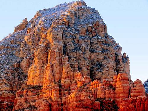
That bastard. Been climbing in Sedona for 12 years and I have exactly 0 shots like that one.

-
Andinistaloco - Posts: 6332
- Joined: Tue Oct 08, 2002 2:32 am
- Thanked: 74 times in 45 posts
Problem with Monument Valley is that the hiking and climbing is extremely limited, as most of it's on private land or in other areas with restricted access. It is incredible, though.
-

coldfoot - Posts: 103
- Joined: Thu Feb 19, 2009 12:58 am
- Thanked: 15 times in 13 posts
The hikearizona.com ratings seem to be mostly difficulty based on strenuousness of hike (length, elevation etc.) and aren't indicative of technical nature. Some hikes I know that are rated 4 or 5 in "difficulty" are long and hard, but Class 1 all the way on paths easy to follow.
Arizona is a big state. I don't think you can easily plan a short trip from a relatively unorganized site like hikearizona. This is a time when you could use a real paper guidebook that has seen the touch of an editor, like the Hiking Arizona book, or pick an area and get a book for that location. It doesn't have to be the perfect book, just one that names a few good outings in your desired place. Have fun.
Arizona is a big state. I don't think you can easily plan a short trip from a relatively unorganized site like hikearizona. This is a time when you could use a real paper guidebook that has seen the touch of an editor, like the Hiking Arizona book, or pick an area and get a book for that location. It doesn't have to be the perfect book, just one that names a few good outings in your desired place. Have fun.
-
coldfoot - Posts: 103
- Joined: Thu Feb 19, 2009 12:58 am
- Thanked: 15 times in 13 posts
jhodlof wrote:coldfoot wrote:The hikearizona.com ratings seem to be mostly difficulty based on strenuousness of hike (length, elevation etc.) and aren't indicative of technical nature. Some hikes I know that are rated 4 or 5 in "difficulty" are long and hard, but Class 1 all the way on paths easy to follow.
Isn't that what I said, but you got one thing wrong, if it is "rated" a number, that is hiker consensus, where as the difficulty is listed as such by the author.
Yes, I just wanted to add the direct comment that a 4 or 5 difficulty can be Class 1, since that's the grade the OP asked about.
I said "rated 4 or 5 in difficulty", I wasn't discussing the hiker consensus quality rating.
I know hikearizona.com has sub-categories by area and so on, but I still think it is too complex and detailed for someone on their first visit to Arizona, who hasn't expressed a desire for a specific type of trip and would probably be well served by hitting a few classic outings.
-

Day Hiker - Posts: 3156
- Joined: Fri Dec 26, 2003 2:57 am
- Thanked: 61 times in 43 posts
Re: Need a Jumpstart - Trip Planning - AZ
1000Pks wrote:Meteor Crater (limited hours)
jdzaharia wrote:In late April, my wife and I will be in Arizona for 4 to 5 days.
I can't guess at your time zone because ND is split between two. But don't forget, outside of Navajo land, Arizona does NOT observe the Daylight Saving hocus-pocus, so they'll be on the same time zone as CA and NV and one hour behind UT and NM. So, if you didn't yet switch your clock when entering AZ, you'll have a bonus hour of abierto in the evening at the crater.
-

jdzaharia - Posts: 403
- Joined: Tue May 02, 2006 5:48 pm
- Thanked: 69 times in 50 posts
Re: Need a Jumpstart - Trip Planning - AZ
jhodlof wrote:The pics from page one are taken from the new Red Rocks Sedona USFS visitor center on AZ Highway 179 just south of the V.O.C., or Village of Oak Creek. Bell Rock is the small bell shaped formation in the center of one of the pics, and Courthouse Butte is on the right of Bell. There is a Wendy's just up the road. I have had their Spicy Chicken, and it was good.
Thanks. Are you trying to facetiously elude to the touristy nature of that area?
jhodlof wrote:traildex map
Thanks for pointing that feature out.
coldfoot wrote:Yes, I just wanted to add the direct comment that a 4 or 5 difficulty can be Class 1, since that's the grade the OP asked about.
I appreciate the input, coldfoot.
I have found the weeding-out of info on Hike AZ to be somewhat tedious. But, very interesting, too.
1000Pks wrote:You may wish to get a few large scale topos
I have ordered the DeLorme map book for AZ, and also the National Geographic Trails Illustrated map for the Superstition and Four Peaks Wilderness areas. I'd like more maps, as I likely will not have the intermess available. I plan to order some USFS maps for Tonto and Coconino. I think they're 1:125k, right?
Day Hiker wrote:I can't guess at your time zone because ND is split between two. But don't forget, outside of Navajo land, Arizona does NOT observe the Daylight Saving
I'm in Central Time. So, Arizona is effectively in Pacific Time during the summer?
-
Day Hiker - Posts: 3156
- Joined: Fri Dec 26, 2003 2:57 am
- Thanked: 61 times in 43 posts
Re: Need a Jumpstart - Trip Planning - AZ
jdzaharia wrote:Day Hiker wrote:I can't guess at your time zone because ND is split between two. But don't forget, outside of Navajo land, Arizona does NOT observe the Daylight Saving
I'm in Central Time. So, Arizona is effectively in Pacific Time during the summer?
Yes, basically. Because MST=PDT=GMT-7.
-
jdzaharia - Posts: 403
- Joined: Tue May 02, 2006 5:48 pm
- Thanked: 69 times in 50 posts
Nobody has mentioned much about the Superstition Mountains. Is it likely to be too hot there at the end of April?
How about Superstition Peak? http://www.summitpost.org/mountain/rock ... -peak.html It looks like there is a designated (possibly marked) trail from Carney Springs/Peralta Rd. But, how is the trail from the Heiroglyphic trailhead. I'm guessing it would be pretty decent for the first bit, but then it looks like off-trail route-finding after that. How far?
How would Superstition Peak compare to Flatiron or other hikes around the Superstitions?
-
jdzaharia - Posts: 403
- Joined: Tue May 02, 2006 5:48 pm
- Thanked: 69 times in 50 posts
Thank you.
It looks like I will not need any passes or permits to park at a trailhead or day hike in Tonto NF, including the Superstition Wilderness. But, it looks like I will need a Red Rocks Pass to park at trailheads near Sedona. Any other fees or passes I should be aware of? Different USFS lands seem to be very inconsistent.
It looks like I will not need any passes or permits to park at a trailhead or day hike in Tonto NF, including the Superstition Wilderness. But, it looks like I will need a Red Rocks Pass to park at trailheads near Sedona. Any other fees or passes I should be aware of? Different USFS lands seem to be very inconsistent.
-
jdzaharia - Posts: 403
- Joined: Tue May 02, 2006 5:48 pm
- Thanked: 69 times in 50 posts
As I read more about hiking and where I want to visit, the theme that keeps recurring is how difficult some of the hiking is. Is it unrealistic for a flatlander to fly from a place where it may well be 40F, to Phoenix and expect to go schlepping up Brown's Peak or Flatiron the next morning? If it's warm, is it unreasonable to hike up some of these features and be back down before the heat really kicks in? I've hiked several times in Zion, western North Dakota, and southeastern Colorado when it's been near 100F. Is AZ that much more brutal?
Is there still snow in the scree chute of Brown's Peak?
Is there still snow in the scree chute of Brown's Peak?
-
- Related topics
- Replies
- Views
- Last post
-
- Help with trip planning AZ and UT
by Rick B » Wed May 05, 2010 10:37 pm - 14 Replies
- 5826 Views
- Last post by Rick B

Tue May 11, 2010 2:23 am
- Help with trip planning AZ and UT
-
- Trip Planning, Texas, New Mexico, April/May
1, 2, 3by jdzaharia » Tue Mar 13, 2012 6:32 pm - 36 Replies
- 12010 Views
- Last post by Bubba Suess
Fri May 11, 2012 4:46 am
- Trip Planning, Texas, New Mexico, April/May
-
- Planning Wheeler Peak NM
by Will5183 » Tue Dec 13, 2016 8:45 pm - 2 Replies
- 4977 Views
- Last post by seano
Wed Dec 14, 2016 11:52 pm
- Planning Wheeler Peak NM
-
- Trip delayed
by Basham » Mon May 09, 2016 2:47 pm - 4 Replies
- 6234 Views
- Last post by Basham
Fri May 13, 2016 2:32 am
- Trip delayed
-
- Trip to GUMO
by ffer_06 » Fri Oct 18, 2013 4:41 pm - 7 Replies
- 6225 Views
- Last post by HippieHiker
Thu Dec 05, 2013 5:03 am
- Trip to GUMO
Who is online
Users browsing this forum: No registered users and 0 guests