Mt Baker

Regional discussion and conditions reports for Washington and Oregon. Please post partners requests and trip plans in the Pacific Northwest Climbing Partners section.
User Avatar
Josh Lewis

 
Posts: 3414
Joined: Thu Jan 06, 2011 11:12 pm
Thanked: 1111 times in 679 posts

Re: Mt Baker

by Josh Lewis » Fri Apr 21, 2017 9:16 am

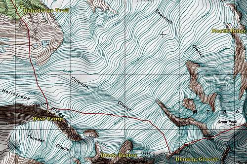
Alpinist wrote:Thanks for the tips. We intend to camp on the glacier at 7200, as marked on the map below. Is that the place that you referenced? Are there toilets there...in the rocks somewhere??

Image


No toilets. Not very many places in Washington Alpine has support for toilets.

User Avatar
ExcitableBoy

 
Posts: 3666
Joined: Wed Nov 09, 2005 9:33 am
Thanked: 663 times in 496 posts

Re: Mt Baker

by ExcitableBoy » Fri Apr 21, 2017 3:11 pm

Yes, that is the campsite I referenced. Josh, there are in fact toilets the NPS installs in the glacier at that campsite. I've climbed and guided that route 30+ times.

User Avatar
ExcitableBoy

 
Posts: 3666
Joined: Wed Nov 09, 2005 9:33 am
Thanked: 663 times in 496 posts

Re: Mt Baker

by ExcitableBoy » Fri Apr 21, 2017 3:15 pm

Sunny Buns wrote:If the weather up north is nasty, you can drive to any of these in a day:

Rainier
Adams
Hood
Jefferson
South Sister, or Middle or North Sister
Shasta


I think if the weather is nasty on Baker one would have to drive at least as far south as Hood to make any difference. Of course, Rainier is high enough that it is possible to climb above the nasty weather. Really hard saying not knowing. Going to the east side of the crest is a more reliable bet and shorter drive, with Mt. Stuart, Dragontail, and Colchuck being obvious, accessible choices.

User Avatar
ExcitableBoy

 
Posts: 3666
Joined: Wed Nov 09, 2005 9:33 am
Thanked: 663 times in 496 posts

Re: Mt Baker

by ExcitableBoy » Sat Apr 22, 2017 6:11 pm

Sunny Buns wrote:Shasta would likely be the most "reliable" for weather, but it's a 9.2 hour 522 mile drive from Sea-Tac to the town of Mt. Shasta. Mandatory stop at The Fifth Season outdoor shop :) ; and for a Burger before heading up to the trailhead :shock: - allow another hour at least for that drive. If I arrive late, I just camp by my car to get a night sleeping at about 6,000' to start the acclimatization. :wink: Don't forget to eat all your fruit before you get to Commiefornia - they will confiscate it at the border.


Good suggestion! I agree that Shasta, especially early May, is an excellent choice and the weather would likely be much better than the North Cascades. FWIW, I drove from the Ravenna District in Seattle (north east of down town, near the University of Washington) to the town of Mt. Shasta in 8 hours flat. I never drove more than 5 miles over the speed limit. We encountered no traffic to speak of, perhaps that is why we made such good time?

Anyhow, there is a restaurant on the far end of town (Billy Goat Tavern?) that is a pretty awesome place to have a burger and a beer. We arrived in the town in time to secure our permits and drove up to Bunny Flats to spend the night in the parking lot (a lot of other folks had the same idea) to acclimatize. We climbed the Casaval Ridge, which I found to be fun and interesting and easier than anything on Rainier or Baker, although we ran into a couple of college students from the east coast who found the Catwalk more than they could tolerate and turned around. It was really no big deal, unless you fell, which would ruin your trip for sure.

User Avatar
seano

 
Posts: 490
Joined: Tue Mar 11, 2008 4:52 pm
Thanked: 132 times in 110 posts

Re: Mt Baker

by seano » Sat Apr 22, 2017 7:29 pm

ExcitableBoy wrote:FWIW, I drove from the Ravenna District in Seattle (north east of down town, near the University of Washington) to the town of Mt. Shasta in 8 hours flat. I never drove more than 5 miles over the speed limit. We encountered no traffic to speak of, perhaps that is why we made such good time?

Was this after the zombie apocalypse, or were you driving in the middle of the night? Seattle was rivaling LA or SF for gridlock last summer.

Also, props to the Hi-Lo Cafe in Weed for epic portions of tasty diner food.

User Avatar
ExcitableBoy

 
Posts: 3666
Joined: Wed Nov 09, 2005 9:33 am
Thanked: 663 times in 496 posts

Re: Mt Baker

by ExcitableBoy » Sat Apr 22, 2017 10:55 pm

seano wrote:Was this after the zombie apocalypse, or were you driving in the middle of the night? Seattle was rivaling LA or SF for gridlock last summer.


No kidding. I live on the Seattle-Eastside and work in the Fremont area. If I am driving into work and leave at 5:55 AM, my commute takes 35 minutes. If I leave at 6:05 AM, my commute takes closer to an hour.

The rush hour in Seattle used to be very predicable, it would be bad around the shift changes at the Boeing plants in Seattle, Renton, and Everett. They run three shifts a day. Now, well I guess it is still predicable. It will always suck no matter what time of day.

We got a true alpine start and I picked my partner up at his house in Ravenna very early on the Friday morning before the Memorial Day week end. We were south of Tacoma on I-5 before the morning rush hour started, which I suspect was especially light any way because of the three day weekend. A lot folks in Seattle work in the tech industry and telecommute or have flex schedules so Monday and Friday mornings rush hour traffic is lighter than Tuesday - Thursday. I was very surprised we made such good time.

LA traffic is a different animal than Seattle. In LA they have 8 lanes of bumper to bumper traffic that moves at highway speeds. I think that is why they have 60 car pile ups. I found it very intimidating to drive there.

User Avatar
Alpinist

 
Posts: 6827
Joined: Tue Jul 29, 2003 7:21 pm
Thanked: 1085 times in 735 posts

Re: Mt Baker

by Alpinist » Sun Apr 23, 2017 3:03 pm

We were planning to climb Baker in May 2014 but the avy conditions in the entire Northern Cascades was extreme at the time, so we ended up driving down to Shasta. We started at the Coquette Falls TH and went up the Whitney Glacier. That's a good back-up plan but as we did that already we'll want to do something different. If the weather or avy conditions are bad in the PNW, then we'll likely head to Olympic NP and climb something at a lower elevation. The east side of the park is a bit dryer and possibly safer than the Cascades when conditions are poor. That would be disappointing but we've already got plane tickets and need to do something.

User Avatar
ExcitableBoy

 
Posts: 3666
Joined: Wed Nov 09, 2005 9:33 am
Thanked: 663 times in 496 posts

Re: Mt Baker

by ExcitableBoy » Sun Apr 23, 2017 8:52 pm

FYI, the weather has been cool and rainy the past couple of weeks so you may have a bit longer road walk than I initially suggested. Still doable, and as long as it doesn't get really hot right before or during your climb, avy conditions should be ok, however, you are right to be concerned. This time of year 'climax' avalanches can occur, which is basically a giant slab avalanche down to the ground or glacier. The Coleman-Demming route gets as steep as 30 degrees on the Roman Wall, the very bottom end of the most likely avalanche terrain.

Mt. Baker is my favorite volcano in the Cascades. I've guided, climbed, and skied it over 30 times by eight different routes. If Baker doesn't work out because of the weather, I highly recommend the Stuart Range for better rather than the Olympics. Really much better mountains with a much shorter drive (especially if you drive around the south end of the Puget Sound) and no ferry necessary (provides a more direct approach from Seattle, but kind of a hassle and not especially inexpensive), although a ferry ride from Seattle to the Olympic Peninsula is a classic Seattle tourist experience. Take a look at the following:

Dragontail Peak: NE Couloir would be a pretty strong mixed climb, and likely in shape, expect technical ice and mixed/rock climbing. Triple Couloirs may or may not be in condition, I've not heard of anyone climbing it this season, but there is latitude on the route if the crux ice runnels are not in shape. A bit easier than the NE Couloir, or harder depending upon the exact route variation and condition, expect technical ice and mixed/rock climbing. These are the most difficult routes that I will suggest.

Colchuck Peak: NE Couloir or North Buttress Couloirs would be good, moderately technical climbs. Easier than the routes I mentioned on Dragontail, but right next door. The Colchuck Lake cirque has been called the most beautiful spot in the Cascades by one of my partners, who is a professional photographer.

Argonaut Peak: NE Couloir, moderately steep climb, may involve some rock climbing, but sports a really cool ridge traverse and 'tunnel' right before the true summit. This is the least commonly climbed peak that I will suggest. Two friends and I made the first winter ascent and one partner made the first ski descent in February many years ago.

Mt. Stuart: Sherpa Glacier, steep snow climb to a classic summit. Ice Cliff Glacier, steeper snow climb, maybe some ice and rock, somewhat dangerous, numerous accidents (including your's truly) and at least one fatality. Stuart Glacier Couloir, my personal favorite route on Stuart for this time of year, offers a steep ice/snow couloir topping out at the beginning of the technical portion of the West Ridge, rock climbing at 5.6, but variations can be done making it more difficult. I found it plenty challenging with crampons and ice/snow covering the rock. I had previously soloed the West Ridge in a day wearing running shoes and found it much more challenging as a mixed climb. Mt Stuart is one of the 50 Classic Climbs in N.A. (the upper North Ridge), and the north face routes I mentioned involve as much elevation gain as the Grand Teton with the same vertical relief as it's north face.

Most of these peaks have non technical routes to the summit and can be done with a single ice axe and crampons. Dragontail via Aasgaud Pass, Colchuck Peak via Colchuck Glacier, Mt. Stuart via Sherpa Glacier from the north. If the approach to the south is open then the Cascadian Couloir would be the easiest rout to the summit, but I don't recommend it. If approaching from the south, here is a fun outing: http://www.summitpost.org/mt-stuart-west-ridge/517399.

Any one of these routes would be, IMNSHO, better than anything in the Olympics you might find. Many are 'bigger' ticks compared with the Coleman-Demming route on Baker. Their position east of the crest gives you better chances of good weather. I don't think you would be disappointed at all if you managed an ascent of any of these routes and peaks. I suggest just be open to other possibilities and bring enough gear (ice tools, rock protection, ice screws) so you are not limited by technical difficulties.

The following user would like to thank ExcitableBoy for this post
Alpinist

User Avatar
Alpinist

 
Posts: 6827
Joined: Tue Jul 29, 2003 7:21 pm
Thanked: 1085 times in 735 posts

Re: Mt Baker

by Alpinist » Mon Apr 24, 2017 3:57 am

Hey - thanks for the suggestions. I'll do some reading on the routes you listed. A couple of people on the team are new to glacier climbing so Baker fit the bill as a good beginner peak for them. Right now, avy conditions are "considerable" at the upper elevations due to wind loading. If that improves, then we'll stick with the plan. If it doesn't, we'll try one of the non-technical routes that you mentioned assuming conditions are better there. Thanks again!

User Avatar
ExcitableBoy

 
Posts: 3666
Joined: Wed Nov 09, 2005 9:33 am
Thanked: 663 times in 496 posts

Re: Mt Baker

by ExcitableBoy » Tue Apr 25, 2017 3:30 pm

Triple Couloirs is in fat shape: http://cascadeclimbers.com/forum/ubbthr ... ost1154575

Something to think about. 20 years ago it was a significant tick, now it is an easy day outing. Depending upon condition of course, and I suspect these conditons will continue for a couple weeks based on the cool, overcast weather we have been experiencing.

Here a recent TR for NE Couloir on Coluchuck. http://cascadeclimbers.com/forum/ubbthr ... ost1154576 When I climbed it we had exposed ice for a couple of pitches, but that was in February quite a number of years ago. Sounds like there is generally more snow this year, especially low down, than most years.

User Avatar
Alpinist

 
Posts: 6827
Joined: Tue Jul 29, 2003 7:21 pm
Thanked: 1085 times in 735 posts

Re: Mt Baker

by Alpinist » Fri Apr 28, 2017 10:17 pm

Sunny Buns wrote:Here's a photo of Dragontail from Colchuck Lake.

http://farm4.static.flickr.com/3309/361 ... e4b1_o.jpg

Back in ~ 1992 we climbed Dragontail on about May 8 or 10. Snow all the way from the parking lot. We camped at the bottom of the peak at the far end of the lake in this photo. Heard rock fall all night. Next day went up the "glacier" on the right to Colchuck Col shown in this photo - we did NOT get on the Serpentine Arete route shown in red. Then worked our way around the back side of the peak to the summit. I think we used ropes but mostly didn't need them as best as I can recall, although they'd be recommended when on any glacier. There was one spot not long after we left the col when we weren't sure which way to go and had to traverse a spot with lots of exposure - made me a tad nervous. Don't remember any difficulties other than that. We glissaded down Aasgard Pass in deep snow at a high rate of speed - it was really fun! Bushwhacking along the right side of the lake to get to camp wasn't fun - I was post-holing with a heavy pack. The brave folks took the easy way and walked on the ice. :)

You could lighten your load and not need a rope by hiking up the left side of the peak to Aasgard Pass, then go right on the back side to the summit. All non-technical; just bring crampons, ice axe, and a helmet would be a good idea. If planning on walking on the ice I would bring a rope in case someone falls through.

Looks like a sweet climb but unfortunately Eightmile Rd is closed for winter at Bridge Creek Campground. That would make for a long approach.

Conditions are looking better for Mt Baker at the moment. Moderate avy conditions are forecast tomorrow at all 3 elevations for west facing slopes.

PreviousNext

Return to Pacific Northwest (WA, OR)


  • Related topics
    Replies
    Views
    Last post

Who is online

Users browsing this forum: No registered users and 0 guests