Longest lines of sight photographed.......

Post general questions and discuss issues related to climbing.
User Avatar
timd

 
Posts: 107
Joined: Thu Mar 23, 2006 5:17 am
Thanked: 0 time in 0 post

by timd » Sat May 02, 2009 9:48 am

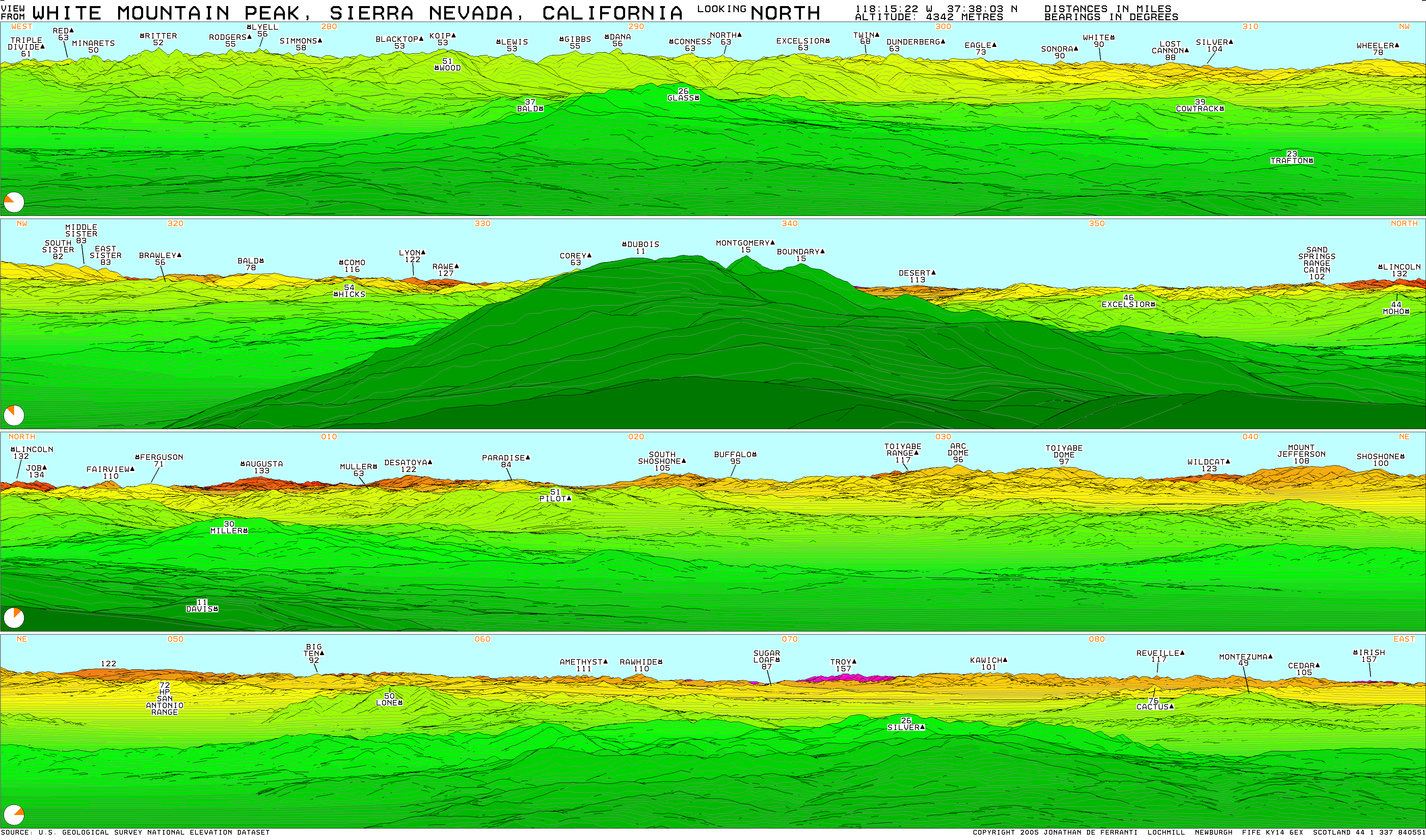
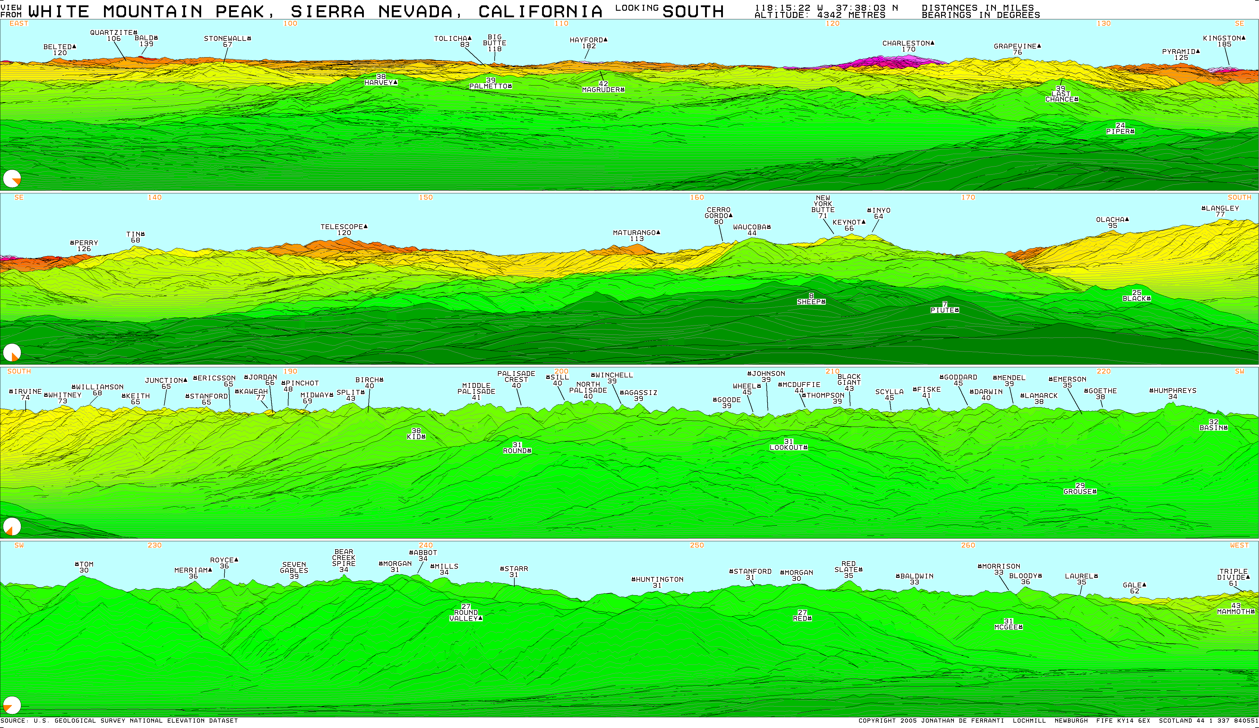
MoapaPk wrote:I can see Russia from my house.

At some point, the curvature of the earth gets in the way. With simple geometry, you can determine if two points can really see each other. This calculation is left as an exercise for the student.


That's nothing, I can see the moon from mine! :lol:

User Avatar
Day Hiker

 
Posts: 3156
Joined: Fri Dec 26, 2003 2:57 am
Thanked: 61 times in 43 posts

by Day Hiker » Sun May 03, 2009 10:33 pm

Iron Hiker wrote:www.viewfinderpanoramas.org has the pano from White Mountain Peak, north of the Barcroft Station and 1,750' higher......

http://www.viewfinderpanoramas.org/pano ... E-MP-N.gif
http://www.viewfinderpanoramas.org/pano ... E-MP-S.gif

The farthest east it seems you can see from there is to Troy Peak and Mount Irish - 157 miles away. That's nowhere close to Utah, however.......but a long way you can see still, to both Hayford and Charleston Peaks, so not too bad.


From the summit of White Mountain Peak, I used my program to check from bearing 052.7 to 181.0, and I also got the following visible peaks:
071.6 Troy Peak: 157.4 miles
088.9 Mount Irish: 156.2 miles
120.8 Angel Peak: 173.7 miles (interesting; Angel is only about 8900 feet)
121.9 Mummy Mountain: 171.0 miles
122.9 Charleston Peak: 169.9 miles
134.8 Kingston Peak: 185.0 miles (really far, and Kingston is only 7336 feet)
147.2 Telescope Peak: 120.0 miles

But I did not get results showing there is a direct line of sight to Hayford Peak. So I checked again, specifically targeting Hayford. The results I got show that Hayford should be just slightly (about .025 degrees or 1.5 arc-minutes) below the ridges of Timber Mountain, at bearing 110.9, here:
http://www.mytopo.com/maps.cfm?mtlat=37.06782&mtlon=-116.44467

Hayford does appear in the images generated by viewfinderpanoramas.org, so I am curious why theirs shows Hayford, and my results don't. I am wondering if we are using different values for the Earth's radius. I am using a spherical Earth, with radius 6371.009 km, which is the mean radius, defined by the International Union of Geodesy and Geophysics. Of course, the Earth is not an exact sphere, so using a simple radius is not exactly correct. But it's pretty close.

Or maybe the viewfinderpanoramas program tries to use the help of atmospheric refraction. My program ignores any potential help from the atmosphere because I'm not sure how much I can count on that phenomenon.

On thing I did see is that there may be a slight discrepancy between actual photos and some viewfinderpanoramas images. Some of the photos I compared on the viewfinderpanoramas site show that it may be rendering distant objects higher in the image than what is actually observed:
http://www.viewfinderpanoramas.org/gallery/usa/whitney.html

In these images, the scale is approximately the same, which can be verified by looking at horizontal distances between corresponding peaks. But it appears to me that some distances in the vertical direction are a bit expanded. For examples, check below San Gorgonio, as well as the entire distant ridge between San Antonio and Waterman, particularly between Waterman and Skinner.

Of course my program is subject to its own errors. I'm not talking mathematical errors (hell no!); math errors probably would result in a completely incorrect image, not one that is only slightly off. But there could be errors due to slight inaccuracies in USGS topo data and maybe even because the Earth is an ellipsoid, slightly flattened at the poles, not spherical.

Of course the only true confirmation would be to look at an actual photo from White Mountain Peak in the direction of Hayford.

User Avatar
MoapaPk

 
Posts: 7780
Joined: Fri May 13, 2005 7:42 pm
Thanked: 787 times in 519 posts

by MoapaPk » Sun May 03, 2009 11:06 pm

DH- It seems to me that you took clear pictures of the CA Sierra from the shoulder of Stirling NV in 2006. How do those pics match with your synthesize projection? If they match, I doubt you have a significant uncertainty from earth radius in that region.

It seems to me that even though the earth is slightly pear-shaped, the planet is still largely radially symmetric about the spin axis. I don't think an ESE view would give that much uncertainty from your spherical approximation.

User Avatar
desainme

 
Posts: 6256
Joined: Thu Sep 19, 2002 6:02 pm
Thanked: 85 times in 65 posts

by desainme » Mon May 04, 2009 3:01 am

I found that one of the longest lilnes of sight this side of the Mississipi is Mt. Washington to Saddleback near Brownville Maine- the distance is 136 miles. Katahdin to the far side of the St. Lawrence is 133 mi and Cadillac Mtn to Katahdin is more than 110 miles.

The line of sight from White Mountain Peak goes somewhere to the middle to Nevada and then from that mountain one can see Wheeler Peak fairly easily. So from this mountain in Nevada one can span the state-east west which is kind of interesting.

User Avatar
Iron Hiker

 
Posts: 42
Joined: Thu Mar 22, 2001 1:00 pm
Thanked: 3 times in 2 posts

by Iron Hiker » Mon May 04, 2009 4:01 am

Desainme,

Good observations! The longest lines of sight in the East that I've established so far are from Camel's Hump in VT south to Black Dome in the Catskills (155 miles). You can ALSO see nearly another 150 miles from the Hump north to mountains in the vicinity of Mont Tremblant in Quebec, so that's probably the longest "span view" in the East.

In the South, Mount LeConte in the Smokies to Garden Mountain in VA is about 150 miles.

Both viewpoints benefit from having long flat valleys in between them.

Even from my little home mountain in NY that I grew up on (2,289' Sam's Point) you can see up the Hudson Valley 120 miles to Mount Equinox in VT! (I've never personally observed it though).

It would be good to have more line of sight pics from the East. The clearer air out West, though, makes it more likely to capture the long views.....

By the way, the Nevada view you are referring to may be Troy Peak. I checked it out the other day and you can see from White Mtn Peak in CA to Signal Peak, UT.

User Avatar
miczanin

 
Posts: 5
Joined: Tue Apr 28, 2009 11:01 am
Thanked: 0 time in 0 post

by miczanin » Mon May 04, 2009 9:20 am

Day Hiker wrote:Or maybe the viewfinderpanoramas program tries to use the help of atmospheric refraction. My program ignores any potential help from the atmosphere because I'm not sure how much I can count on that phenomenon.


Yes, in order to be realistic you have to consider atmospheric refraction... its effect is not easy to model, because it depends on many factors, some of them almost impossible to know. So, it is necessary to approximate it. Both our marmota system and viewfinderpanoramas use a simple function of distance. We have an extensive experience of matching synthetic data with real photos and the approx we use is to reduce the effect of earth curvature by multiplying it by 0.859 (empirical magic number!).
In some rare case the refraction effect is stronger and our model is too pessimistic. Viewfinderpanoramas aim is not direct photo matching, but to contemplate also exceptional conditions, so it uses a very optimistic refraction model, that is almost equivalent to using 0.825 instead of 0.859 in our system.

We discussed these differences in our 'longest line of sight' blog entry: http://tev.fbk.eu/marmota/blog/2008/10/21/longest-line-of-sight-an-update/

User Avatar
Clydascope

 
Posts: 1106
Joined: Thu Aug 15, 2002 2:44 pm
Thanked: 28 times in 12 posts

by Clydascope » Mon May 04, 2009 2:42 pm

I'll be headed back up to Barcroft later in the summer and will see if the map is still there. Stay tuned for details...

User Avatar
Dmitry Pruss

 
Posts: 829
Joined: Mon Apr 18, 2005 1:17 am
Thanked: 2 times in 2 posts

by Dmitry Pruss » Mon May 04, 2009 7:21 pm

miczanin wrote:We have an extensive experience of matching synthetic data with real photos and the approx we use is to reduce the effect of earth curvature by multiplying it by 0.859 (empirical magic number!).


The refraction effect is due to the reduction of air density (and hence refraction coefficient) with altitude? Would it be lower at higher elevations (where refraction values at all relative elevations are lower?)

And the higher the atmospheric pressure, the higher would be the refraction correction too?

Interesting. And I really can't help comparing it with a sci fi book my kid is reading now :) There, the refraction effect in the atmosphere is such that there is no real horizon, and one can see as far as the transparency of the air allows (which isn't very far) ... so the prevailing theory of the locals is that they live on the inside surface of a planetary sphere.

User Avatar
Dmitry Pruss

 
Posts: 829
Joined: Mon Apr 18, 2005 1:17 am
Thanked: 2 times in 2 posts

by Dmitry Pruss » Mon May 04, 2009 8:50 pm

... just came across T Chester's site

http://tchester.org/sgm/analysis/peaks/view_params.html

and there he claims that the refraction correction of Earth curvature effect falls quite dramatically at higher elevations, eliminating less than 10% of it at 10,000 ft and perhaps as little as 8% at 16,000 ... which is substantially less than Marmota's 14% correction. But Marmota's values are emprically derived and therefore must be rather correct for the conditions where the analyzed photos were taken ... which raises a question, did the analysis include higher elevation panoramas?

User Avatar
MoapaPk

 
Posts: 7780
Joined: Fri May 13, 2005 7:42 pm
Thanked: 787 times in 519 posts

by MoapaPk » Mon May 04, 2009 9:42 pm

MOCKBA wrote:
The refraction effect is due to the reduction of air density (and hence refraction coefficient) with altitude? Would it be lower at higher elevations (where refraction values at all relative elevations are lower?)


I'd guess so; the differential version of Snell's law can be integrated from a starting azimuth. Since the index of refraction drops with altitude, the ray will be gradually bent down.

How does the index of refraction of air go with density? We can calculate the density with altitude. I will be interesting to see where the theoretical answer (for the total refraction effect) falls in comparison with reality.

User Avatar
Dmitry Pruss

 
Posts: 829
Joined: Mon Apr 18, 2005 1:17 am
Thanked: 2 times in 2 posts

by Dmitry Pruss » Mon May 04, 2009 10:06 pm

Chester's calculation isn't very far off as you can see; to do a "real" "exact" calculation, one would have to obtain measurements of temperature / pressure / humidity at all elevations between the camera and the peak being photographed ... so of course the formulas use a series of assumptions and simplifications. Which may or may not be right.

Most notably, if you have temperature inversion conditions, the vertical gradient of air density may become more pronounced, and then your distance of sight may be longer than the models predict?

User Avatar
Day Hiker

 
Posts: 3156
Joined: Fri Dec 26, 2003 2:57 am
Thanked: 61 times in 43 posts

by Day Hiker » Tue May 05, 2009 3:43 pm

MoapaPk wrote:DH- It seems to me that you took clear pictures of the CA Sierra from the shoulder of Stirling NV in 2006. How do those pics match with your synthesize projection? If they match, I doubt you have a significant uncertainty from earth radius in that region.

It seems to me that even though the earth is slightly pear-shaped, the planet is still largely radially symmetric about the spin axis. I don't think an ESE view would give that much uncertainty from your spherical approximation.


Thanks for the reassurance about using a spherical Earth. I still plan to eventually use the ellipsoid model, but I haven't yet incorporated that into my code. When I do, I will make some comparisons, just to see if it makes any visible difference.

I checked my photos from 29 Jan 2006, and I have photos from Stirling, but all the telephoto shots are from Peak 2421m. So I will need to generate images using that viewpoint, instead of the views from Stirling that I already have.

We did have some high clouds that day that reduced the contrast between distant peaks and sky, so it will still be hard to do the comparison. I did get some clear shots of the petroglyphs up there, but I doubt I'll have good luck when I compare those shots with topo simulations.

User Avatar
Day Hiker

 
Posts: 3156
Joined: Fri Dec 26, 2003 2:57 am
Thanked: 61 times in 43 posts

by Day Hiker » Tue May 05, 2009 4:16 pm

miczanin wrote:
Day Hiker wrote:Or maybe the viewfinderpanoramas program tries to use the help of atmospheric refraction. My program ignores any potential help from the atmosphere because I'm not sure how much I can count on that phenomenon.


Yes, in order to be realistic you have to consider atmospheric refraction... its effect is not easy to model, because it depends on many factors, some of them almost impossible to know. So, it is necessary to approximate it. Both our marmota system and viewfinderpanoramas use a simple function of distance. We have an extensive experience of matching synthetic data with real photos and the approx we use is to reduce the effect of earth curvature by multiplying it by 0.859 (empirical magic number!).
In some rare case the refraction effect is stronger and our model is too pessimistic. Viewfinderpanoramas aim is not direct photo matching, but to contemplate also exceptional conditions, so it uses a very optimistic refraction model, that is almost equivalent to using 0.825 instead of 0.859 in our system.

We discussed these differences in our 'longest line of sight' blog entry: http://tev.fbk.eu/marmota/blog/2008/10/21/longest-line-of-sight-an-update/


I'm convinced about the effect of atmospheric refraction. After all, it's what brings up the bottom of the Sun's shape during sunrise and sunset, flattening it into what is definitely non-circular.

In your determination of the empirical value .859, did you establish this using multiple views or the one long, 500 km view from your link?

I also thought about using a factor to reduce the Earth's curvature, but I haven't had a chance to do any work with that yet. And I will need to select some appropriate viewpoints and photos to arrive at an empirical value like you did. I guess I could just steal your number for a starting point, but I would eventually want to confirm it.

For the code, the complicated part for me is that I use the Earth's radius to determine where a point is, in 3-D space, not just how much of Earth's curvature is between it and an observer. Simply increasing the radius for all calculations would not give me proper results. I would need to somehow use this adjustment factor only after I have determined each point's location.

User Avatar
Day Hiker

 
Posts: 3156
Joined: Fri Dec 26, 2003 2:57 am
Thanked: 61 times in 43 posts

by Day Hiker » Tue May 05, 2009 4:31 pm

MoapaPk wrote:
MOCKBA wrote:
The refraction effect is due to the reduction of air density (and hence refraction coefficient) with altitude? Would it be lower at higher elevations (where refraction values at all relative elevations are lower?)


I'd guess so; the differential version of Snell's law can be integrated from a starting azimuth. Since the index of refraction drops with altitude, the ray will be gradually bent down.

How does the index of refraction of air go with density? We can calculate the density with altitude. I will be interesting to see where the theoretical answer (for the total refraction effect) falls in comparison with reality.


Just to complicate things more, I wonder how much of the observed effect is due to the atmosphere and how much is due to gravity. I know that link focuses on more massive objects, like galaxies, but light does "bend" in any gravitational field. (Or light travels in a straight line, and space is bent.)

User Avatar
MoapaPk

 
Posts: 7780
Joined: Fri May 13, 2005 7:42 pm
Thanked: 787 times in 519 posts

by MoapaPk » Tue May 05, 2009 5:12 pm

That's why some very dense people have poor vision.

PreviousNext

Return to General


  • Related topics
    Replies
    Views
    Last post

Who is online

Users browsing this forum: No registered users and 0 guests