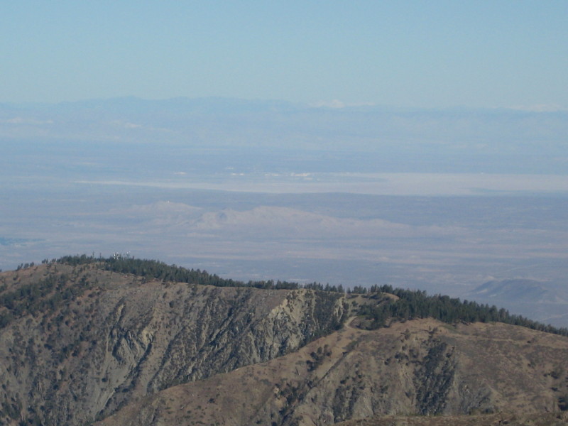
There are two clusters of snowy peaks in the distance. I assume that the peaks on the right are the Whitney/Langley group. But what is that snowy peak on the left (which is actually in the top center of the photo)?


Sam Page wrote:There are two clusters of snowy peaks in the distance. I assume that the peaks on the right are the Whitney/Langley group. But what is that snowy peak on the left (which is actually in the top center of the photo)?
yaknjorgl wrote:yo-
it might be Olancha Peak or that stuff there


SpiderSavage wrote:Day Hiker, Can you post your map??
ksolem wrote:OK I don't have any fancy software or such, but I'm not getting how Olancha peak and Langley can be off frame right of the Whitney group from there when they are to the south.
Just by eye I would guess you're seeing the Whitney area crest in the center, The Inyo/Whites to the right and the Owens Valley between. Without a compass bearing for the camera it's just a guess.
Day Hiker wrote:Upon closer inspection, it looks like Langley might also be cut out of the photo, and that's just Whitney and some 13-ers on the right. But Langley would definitely be at least as obvious as Whitney from this viewpoint, appearing roughly as high, but having a broader, more dome-shaped appearance from this angle.
Day Hiker wrote:SpiderSavage wrote:Day Hiker, Can you post your map??
Yes. I need a few to make a better one, worthy of posting.ksolem wrote:OK I don't have any fancy software or such, but I'm not getting how Olancha peak and Langley can be off frame right of the Whitney group from there when they are to the south.
Just by eye I would guess you're seeing the Whitney area crest in the center, The Inyo/Whites to the right and the Owens Valley between. Without a compass bearing for the camera it's just a guess.
It will make sense when you see the generated image. The smaller hills in the foreground match up with those in the photo, as well, helping to confirm the camera direction.
By the way, my "fancy software" is just Microsoft Excel, and I did all the math and wrote all the Visual Basic code for this myself. I spent a lot of time but no money.


Day Hiker wrote:By the way, my "fancy software" is just Microsoft Excel, and I did all the math and wrote all the Visual Basic code for this myself. I spent a lot of time but no money.

Luciano136 wrote:I'm also a bit puzzled why the southern peaks appear to the right of Whitney though? Is Mt Baldy not slightly to the east of the Sierra group? Or are Olancha and Langley significantly east of Whitney?
Luciano136 wrote:I'm also a bit puzzled why the southern peaks appear to the right of Whitney though? Is Mt Baldy not slightly to the east of the Sierra group? Or are Olancha and Langley significantly east of Whitney?
johnm wrote:Luciano136 wrote:I'm also a bit puzzled why the southern peaks appear to the right of Whitney though? Is Mt Baldy not slightly to the east of the Sierra group? Or are Olancha and Langley significantly east of Whitney?
He has it correct, that threw me as well but if you look at google terrain and the way the peaks align from Baldy it makes sense. Your looking at Olancha in a Northeasterly direction and Olancha is the closest of the three. So if your driving up 395 once you are around Olancha your change your heading to northwest so Langley and Whitney would align slighly left of Olancha.
Users browsing this forum: No registered users and 0 guests

