Bear Creek Spire, South Face
13 posts
Page 1 of 1
-

m_dquist - Posts: 48
- Joined: Tue Aug 29, 2006 5:14 am
- Thanked: 1 time in 1 post
Bear Creek Spire, South Face
Has anyone climbed any routes on the South Face of Bear Creek Spire? Not a lot of information out there on this wall. Any feedback would be great, and I'm also curious about how to get back down to a camp on the south side if anyone's done it this way rather than descending on the north side into Rock Creek. I climbed the East Ridge of BCS a while back but can't remember how easy it would be to climb over the toe of that ridge from the north side to access the South Face. So we'll probably end up approaching from Pine Creek and descending back to the south if possible.
-

JedSMG - Posts: 125
- Joined: Mon Apr 14, 2008 9:37 pm
- Thanked: 23 times in 10 posts
Re: Bear Creek Spire, South Face
Dude, just stash a bike. Come on! And then go to the Gallery in Bishop. That's how you roll, right? A Rowell route, then a Gallery visit.
-

sharperblue - Posts: 447
- Joined: Wed Dec 06, 2006 4:05 am
- Thanked: 80 times in 58 posts
Re: Bear Creek Spire, South Face
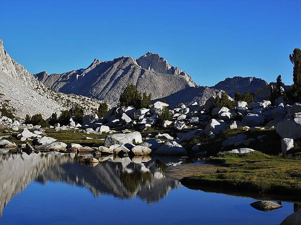
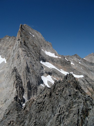
I've got some fantastic shots of BCS's South face as it intersects the ridgeline (dropping South) and becomes Apollo Peak - in other words, a likely descent route from the top back into Pine Creek; it should be completely reasonable. Give me a few to pull and post them, but the ridgeline looks Class 4 for a few hundred feet, then onto Apollo (Class 2 to base)
-
sharperblue - Posts: 447
- Joined: Wed Dec 06, 2006 4:05 am
- Thanked: 80 times in 58 posts
Re: Bear Creek Spire, South Face
ok, apologies for the delay. shot of east arete to summit, from Apollo last year:
http://www.summitpost.org/bcs-east-aret ... 0/c-150612
not a beautiful shot, but should be informative. You'll likely go down the scree under all that snow so fast you'll go back in time
http://www.summitpost.org/bcs-east-aret ... 0/c-150612
not a beautiful shot, but should be informative. You'll likely go down the scree under all that snow so fast you'll go back in time
-

granjero - Posts: 127
- Joined: Sun Nov 30, 2008 8:47 am
- Thanked: 46 times in 29 posts
Re: Bear Creek Spire, South Face
Morgan pass trail is your descent if doing it out and back from PC (though it would still be a loop, albeit just not a very round one). I second the motion for bicycle stashing. Dont forget to stash reefer and beer for your coast down the hill! 
-
sharperblue - Posts: 447
- Joined: Wed Dec 06, 2006 4:05 am
- Thanked: 80 times in 58 posts
Re: Bear Creek Spire, South Face
The Chief wrote:
Ok, that's a nice shot
-

Deb - Posts: 3161
- Joined: Sun Sep 29, 2002 1:57 pm
- Thanked: 218 times in 136 posts
Re: Bear Creek Spire, South Face
Why can't you drop down towards Peppermint on the east ridge? I know it's only Class 2 from there down to the "trail" on the south side. Then exit on Pine Creek trail. Don't go all the way to Spire Col. There's an obvious difference in rock color and quality; almost like someone started a new project building Peppermint Peak.
OR, you can go down Spire Col and exit on the Morgan Pass trail (looks boring).
OR, you can go down Spire Col and exit on the Morgan Pass trail (looks boring).
-

fatdad - Posts: 1463
- Joined: Tue Jul 24, 2007 9:39 pm
- Thanked: 101 times in 71 posts
Re: Bear Creek Spire, South Face
Two things:
One, you can ride your bike up to Morgan Pass from Pine Creek? Really? Sounds fun.
Two, I remember reading in an old AAJ (late 70s/early 80s) a report from Galen Rowell about a climb he did called the British Chimney Route or something like that. Sounded interesting.
One, you can ride your bike up to Morgan Pass from Pine Creek? Really? Sounds fun.
Two, I remember reading in an old AAJ (late 70s/early 80s) a report from Galen Rowell about a climb he did called the British Chimney Route or something like that. Sounded interesting.
-

Michael Graupe - Posts: 153
- Joined: Thu Apr 24, 2003 10:55 am
- Thanked: 9 times in 8 posts
Re: Bear Creek Spire, South Face
Deb wrote:Why can't you drop down towards Peppermint on the east ridge? I know it's only Class 2 from there down to the "trail" on the south side. Then exit on Pine Creek trail. Don't go all the way to Spire Col. There's an obvious difference in rock color and quality; almost like someone started a new project building Peppermint Peak.
Deb, are you suggesting to drop down this ridge? Looks difficult. This is the view from Peppermint.
-
m_dquist - Posts: 48
- Joined: Tue Aug 29, 2006 5:14 am
- Thanked: 1 time in 1 post
Re: Bear Creek Spire, South Face
We ended up just climbing over Spire Col from the Little Lakes Valley side and it was no problem to just return down Ulrich's Route to our camp. Finding the route, however, was not easy. Unable to identify the line, we just picked what looked climbable and ended up climbing something that bore no resemblance to the cryptic description in Rowell's AAJ article and required a decent amount of aid in the upper pitches.
Can anyone identify Rowell's South Face route on sharperblue's photo above? (awesome photo by the way, wish I saw it before we headed there!)
http://www.summitpost.org/bcs-east-aret ... 0/c-150612
I'm trying to figure out if we did at least a partial FA or not; the bottomed cracks on some of the upper pitches were flaky enough in the only places they'd take gear that I highly doubt they'd been climbed, there were also sections I'd put at 5.11 that I doubt Galen freed and called 5.9. (we aided them!)
I've got a route overlay of the route we did, PM me if interested.
-
sharperblue - Posts: 447
- Joined: Wed Dec 06, 2006 4:05 am
- Thanked: 80 times in 58 posts
Re: Bear Creek Spire, South Face
m_dquist wrote:We ended up just climbing over Spire Col from the Little Lakes Valley side and it was no problem to just return down Ulrich's Route to our camp. Finding the route, however, was not easy. Unable to identify the line, we just picked what looked climbable and ended up climbing something that bore no resemblance to the cryptic description in Rowell's AAJ article and required a decent amount of aid in the upper pitches.
Can anyone identify Rowell's South Face route on sharperblue's photo above? (awesome photo by the way, wish I saw it before we headed there!)
Here's a more complete shot of the South Face; there's a line drawn on the face in a photo in the Moynier/Fiddler Guide that indicates the Rowell route and its companion both tracking straight up either side of the arete (the 'serrated fin') casting the strong shadow about 3/4 way over the face from the East - that should be ' South Face'
http://www.summitpost.org/bcs-south-fac ... 9/c-150612
-
Deb - Posts: 3161
- Joined: Sun Sep 29, 2002 1:57 pm
- Thanked: 218 times in 136 posts
Re: Bear Creek Spire, South Face
Michael Graupe wrote:Deb wrote:Why can't you drop down towards Peppermint on the east ridge? I know it's only Class 2 from there down to the "trail" on the south side. Then exit on Pine Creek trail. Don't go all the way to Spire Col. There's an obvious difference in rock color and quality; almost like someone started a new project building Peppermint Peak.
Deb, are you suggesting to drop down this ridge? Looks difficult. This is the view from Peppermint.
Yeah...nevermind. Not knowing where the OP's route begins....I guess it's a dumb idea to downclimb the east ridge.
13 posts
Page 1 of 1
-
- Related topics
- Replies
- Views
- Last post
-
- Bear Creek Spire - Rock Creek Road?
1, 2") by Burchey » Wed Feb 27, 2013 8:03 pm
by Burchey » Wed Feb 27, 2013 8:03 pm
- 28 Replies
- 16631 Views
- Last post by BHunewill

Sun May 05, 2013 10:36 pm
- Bear Creek Spire - Rock Creek Road?
-
- Bear Creek Spire Thievery
1, 2 by lefty » Thu Jun 28, 2012 5:33 am
- 18 Replies
- 6577 Views
- Last post by Carbo
Mon Jul 09, 2012 7:46 pm
- Bear Creek Spire Thievery
-
- Approach to Bear Creek Spire
by SKI » Tue Nov 09, 2010 2:51 am - 12 Replies
- 4543 Views
- Last post by hamik
Tue Apr 12, 2011 8:31 pm
- Approach to Bear Creek Spire
-
- Hikes near Bear Creek Spire ???
by info@reddevilrecords.net » Thu Jul 02, 2015 1:56 am - 5 Replies
- 2643 Views
- Last post by Deb
Sun Jul 05, 2015 12:26 am
- Hikes near Bear Creek Spire ???
Who is online
Users browsing this forum: No registered users and 0 guests