Desert Water Agency (DWA) property

Regional discussion and conditions reports for the Golden State. Please post partners requests and trip plans in the California Climbing Partners forum.
User Avatar
estunum

 
Posts: 7
Joined: Tue Oct 04, 2011 10:51 pm
Thanked: 0 time in 0 post

Re: Desert Water Agency (DWA) property

by estunum » Tue Oct 04, 2011 11:28 pm

surgent wrote:How effectively is famous Sect 33 posted? What kind of signs are present, and the fencing? If it is well-posted, then this works in your favor: if you or your car are clearly outside their land, then they have no purview to do anything to you, and you can fight this in a court if need be, but you need to be sure you have the evidence to back your claim.


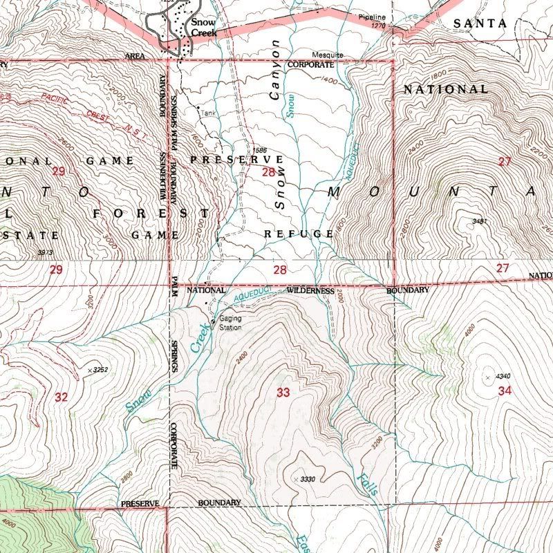
I have always been reluctant to join simmitpost since what I do is canyoneer, and find that other forums fit my needs best. Though this is an interesting topic as I am planning a trip to the upper falls and ran across this thread when looking for more info about section 33. I have been to this area only twice, once years ago and last week to recon for my trip. So I feel I can add about the postings in the area. To better visualize what I'm about to explain, I suggest you download my Google Earth file. KMZ format, 3.72MB.

Link: http://dl.dropbox.com/u/21171949/Falls%20Creek.kmz

I create such files on first time trips to canyons, or if it involves any form of cross-country or bushwhacking. You can disregard most of the labels, but the boxes are blue, red, green, for sections 33, 28, 21, respectively. On both of my encounters with DWA there, any point south past the start of the PCT trail (green icon) is not allowed. So one can use that road you see there (hiking), up to that point. There's no signs that say that until a few yards from there, where you'll see TRESPASSING signs about every half mile. Or so I guess, I didn't push my luck that much. That's just on the road.

On the delta floor, there are no signs whatsoever that let you know you're now stepping in section 33. DWA simply forbids the whole area as a whole, to avoid getting technical. If you do, one can go all the way up the road, and even to one of those installations you see on the map. They only own section 33 as far as I know, so I do not know why they claim section 28 too. They will stop you past the PCT start, but that is still section 28 a ways up. I see why they would do that, but it isn't technically theirs. I am not here to create friction by the way, let's get that straight. Throughout this thread there's quick finger pointing as if those asking questions are in a mission to trespass and to hell with the law. No. On both of my encounters, DWA has been polite and helpful. That's how I know about the signs further south. I don't intend, much less condone, trespassing.

One more note on the file, notice that you can check on or off any individual label from the left sidebar. By default, I have the topo map off, so if you find that helpful it's just a click away to turn it on.

EDIT:

From just reading here every possible mention about ownership of sec 33, it is often said that is per public records. Where is this record? Can someone point me in the correct direction to get it? I'd be handy to carry with me just in case they want to get froggy. Also, it might save my ass from just relying on forum posts, who knows, maybe they now own more sections.

no avatar
tradmonkey

 
Posts: 58
Joined: Tue Mar 29, 2005 7:36 pm
Thanked: 4 times in 2 posts

Re: Desert Water Agency (DWA) property

by tradmonkey » Mon Oct 10, 2011 3:55 pm

estunum wrote:From just reading here every possible mention about ownership of sec 33, it is often said that is per public records. Where is this record? Can someone point me in the correct direction to get it? I'd be handy to carry with me just in case they want to get froggy. Also, it might save my ass from just relying on forum posts, who knows, maybe they now own more sections.


This is probably the most accessible resource: http://www3.tlma.co.riverside.ca.us/pa/rclis/

Section 33 is pretty well marked on the USGS topos (most I've seen anyway) and it's definitely possible to avoid the plot on a trip up snow creek. Know when you're on their land and when you're not. If they harass you on public land, let us know!

A couple of months ago, a Snow Creek local gathered up other interested climbers got the attention of the Access Fund and the Allied Climbers of San Diego. The three co-authored a letter to the DWA requesting that they cease the harassment of climbers and hikers passing by on public land. In return, we have promised to educate the public about Section 33 and how to avoid it, and encourage Leave No Trace practices including the use of 'wag bags' by those passing through the watershed.

Some time this fall, I expect to have a webpage up that details how to climb Snow Creek legally. I still have some research to do as the temps creep down to a tolerable level. I'll be sure to keep Summitpost up to speed.

Thanks,
Adam

The following user would like to thank tradmonkey for this post
cbuelow

User Avatar
estunum

 
Posts: 7
Joined: Tue Oct 04, 2011 10:51 pm
Thanked: 0 time in 0 post

Re: Desert Water Agency (DWA) property

by estunum » Thu Oct 13, 2011 11:06 pm

Yea, section 33 is clearly marked on topos, but only section 33. The reason I ask about the public record is to see if they have possibly acquired additional land. That web site didn't prove helpful, but thanks anyways!

My hometown is Indio, so perhaps I am gonna have to attend that monthly meeting and get it straight from them. Specially with what I ran across recently. I noticed that topo maps are always dated from the 80s, even 70s. I found a map of that area dated from 1996, and from what I can tell, both section 33 and 28 are theirs. There's actually other sections labeled as "corporate" I had never seen labeled either, but those aren't in question. So if I am looking at this correctly, the DWA is actually being kind to let people access that area for the PCT. Here's the map...

Image

no avatar
tradmonkey

 
Posts: 58
Joined: Tue Mar 29, 2005 7:36 pm
Thanked: 4 times in 2 posts

Re: Desert Water Agency (DWA) property

by tradmonkey » Thu Oct 13, 2011 11:46 pm

Interesting! I could swear that just a month or two ago, all of those parcels that now indicate "owner names not available online" had specific owner name information for nearly all of them. Wonder what the deal is now. I don't recall specifically the ownership of section 28...

Adam

User Avatar
estunum

 
Posts: 7
Joined: Tue Oct 04, 2011 10:51 pm
Thanked: 0 time in 0 post

Re: Desert Water Agency (DWA) property

by estunum » Fri Oct 14, 2011 6:33 am

While neither has owner names, section 33 does have the mailing address "C/O CONTROLLER P O BOX 1710 PALM SPRINGS CA. 92263" which is the DWA's contact address. Nothing on 28, but on the topo map on my previous map it is labeled Corporate Boundary and has a dotted line around it just like 33.

no avatar
coldfoot

 
Posts: 103
Joined: Thu Feb 19, 2009 12:58 am
Thanked: 15 times in 13 posts

Re: Desert Water Agency (DWA) property

by coldfoot » Fri Oct 14, 2011 9:14 am

I don't know anything about this situation, but from looking at the topo map I think "Corporate Boundary" is to be read "Palm Springs Corporate Boundary," that is the edge of the incorporated municipality. I don't think "Corporate Boundary" is usually used to mean ownership by a corporation or private entity. So I wouldn't read too much into that. Topo maps aren't the official reference for land ownership, of course.

no avatar
tradmonkey

 
Posts: 58
Joined: Tue Mar 29, 2005 7:36 pm
Thanked: 4 times in 2 posts

Re: Desert Water Agency (DWA) property

by tradmonkey » Fri Oct 14, 2011 3:43 pm

I emailed the GIS contact for that web reference about owner names and got this back...

The publicly viewable online mapping application (RCLIS) no longer shows owner names. If you have GIS software (ArcGIS) you can download our data from here: http://www.rctlma.org/gis/content/data.aspx


I have ArcGIS and will see what I can do with it this weekend.

User Avatar
ExcitableBoy

 
Posts: 3666
Joined: Wed Nov 09, 2005 9:33 am
Thanked: 663 times in 496 posts

Re: Desert Water Agency (DWA) property

by ExcitableBoy » Fri Oct 14, 2011 4:06 pm

coldfoot wrote:Topo maps aren't the official reference for land ownership, of course.


I have a friend that found that out the hard way. He put up what is considered the longest sport climb in N.A. (26 pitches) on a mountain, part of which is in a wilderness area. Using a United States Geological Survey Map for his reference, he put his route outside the wildnerness area using a gas powered drill. Turns out the map boundry was incorrect and he had inadvertently installed his route inside the wilderness boundry much to the hand wringing of Forest Service officals and the anti bolting crowd.

User Avatar
surgent

 
Posts: 545
Joined: Wed Aug 20, 2003 2:45 pm
Thanked: 143 times in 80 posts

Re: Desert Water Agency (DWA) property

by surgent » Fri Oct 14, 2011 4:16 pm

coldfoot wrote:I don't know anything about this situation, but from looking at the topo map I think "Corporate Boundary" is to be read "Palm Springs Corporate Boundary," that is the edge of the incorporated municipality. I don't think "Corporate Boundary" is usually used to mean ownership by a corporation or private entity. So I wouldn't read too much into that. Topo maps aren't the official reference for land ownership, of course.


This is correct. Corporate Boundary means city limits on the topo, but these can change often, too.

The BLM maps (1:100000 scale) are usually more detailed as to what's public and private, and updated a little more often than the USGS maps.

no avatar
KathyW

 
Posts: 1656
Joined: Wed Jun 25, 2003 7:07 am
Thanked: 53 times in 39 posts

Re: Desert Water Agency (DWA) property

by KathyW » Sat Oct 15, 2011 6:42 am

Knowing the ownership shown per "public record" does not tell you everything. Just because one entity pays the property taxes, it doesn't mean they are the entity who holds all the rights to the property.

User Avatar
estunum

 
Posts: 7
Joined: Tue Oct 04, 2011 10:51 pm
Thanked: 0 time in 0 post

Re: Desert Water Agency (DWA) property

by estunum » Sat Oct 15, 2011 6:54 am

Perhaps this is what the DWA relies on. So many details are lost in paperwork from the city, county, the state, permits, wilderness, or whatever you want to add, that they can essentially make up their own rules for the area. Whenever I do go home, I do intend to do so in a time frame that I can sit in the meeting and ask questions. Of course I might get nothing more than their biased opinion, but at least whatever they say I can attach a source to it. Going off earlier posts on this thread, this damn sense of entitlement on both sides is what's causing the friction to begin with.

no avatar
tomd

 
Posts: 19
Joined: Wed Apr 13, 2005 5:04 pm
Thanked: 0 time in 0 post

Re: Desert Water Agency (DWA) property

by tomd » Tue Aug 19, 2014 5:26 am

Adam found out The DWA also leases section 28 from the San Bernardino National Forest, which is just north of section 33. This may be how they claim to have the right to eject people from there, not just section 33.
The lease is now up for renewal. (it expired in 1997 so anyone who has been ticketed on section 28 since then was falsely ticketed.)
We need a condition added to the new lease to allow hiker access.
Ideally the lease would also be conditional on allowing hiker access to section 33, up the isthmus between Falls creek and Snow creek and then over to Snow creek. this would generally keep people out of the drainages as much as possible to reduce impacts.
Hikers should hike thru, and not camp on those sections.
http://data.ecosystem-management.org/ne ... ject=37895

Desert Water Agency Permit Renewal - Special use management Developing Proposal
Est. Scoping Start 07/2014 Expected:09/2014 10/2014 Heidi Hoggan
909-382-2945
hhoggan@fs.fed.us
Description: DWA's current permit is expired. The water system (pipelines, reservoir, and access roads) serves the City of Palm Springs and the community of snow creek. Hydroelectric power generated. The permit needs to be renewed and updated.
Web Link: http://www.fs.fed.us/nepa/nepa_project_ ... ject=37895

Comments are due by Aug 28, can email to Heidi Hoggan at hhoggan@fs.fed.us
click on Scoping letter to find out more how to comment.

old thread on this subj. dwa-illegally-harrasing-hikers-at-snow-creek-t52729-165.html

User Avatar
MoapaPk

 
Posts: 7780
Joined: Fri May 13, 2005 7:42 pm
Thanked: 787 times in 519 posts

Re: Desert Water Agency (DWA) property

by MoapaPk » Tue Aug 19, 2014 4:18 pm

http://caltopo.com/map.html#ll=33.8752, ... 0.47&a=sma

Our local mountains have a fair amount of land "leased" from USFS, and it is treated much like private property -- with some bizarre exceptions (like the lessees must allow hunting on the land, with proper regard for public safety). The Las Vegas Ski and Snowboard area is "leased" from the USFS, but they have lots of permanent buildings, tows, etc. and they certainly restrict access during ski season. The Foxtail Canyon area is leased to the Girl Scouts for some very trivial fee; they can deny access to anyone wandering on "their" land. They have been very nice to me -- but the caretaker insists it is private land. A lot of homes in Kyle Canyon are built on leased land.

no avatar
KathyW

 
Posts: 1656
Joined: Wed Jun 25, 2003 7:07 am
Thanked: 53 times in 39 posts

Re: Desert Water Agency (DWA) property

by KathyW » Wed Aug 20, 2014 1:54 am

TomD - Thanks for the info. I'll take a look at it and send my comments.

It's important for the agencies that manage our lands to hear from us. Sometimes it does feel like they are not listening, but that does not mean we should not keep trying to be heard.

User Avatar
hikin_jim

 
Posts: 46
Joined: Thu May 31, 2007 6:09 pm
Thanked: 0 time in 0 post

Re: Desert Water Agency (DWA) property

by hikin_jim » Thu Aug 28, 2014 4:13 pm

For what it's worth, here's my letter to the USFS:
To: Heidi Hoggan, USFS Project Lead, Desert Water Agency Reissuance
Subject: Scoping -- Desert Water Agency Reissuance
Date: 28 Aug 2014

I. It has come to my attention that the lease held by the Desert Water Agency (hereinafter referred to as the DWA) of the National Forest lands in Township 3 South, Range 3 East, Section 28 (hereinafter referred to as simply "Section 28") is currently in the process of being renewed.

II. I have examined the DWA's application for renewal, and I find that it is substantially incomplete. To wit:
A. Structures. Those structures operated by the DWA which can be clearly seen in a satellite photograph of Section 28 are not enumerated in the DWA's application for renewal. Inasmuch as those structures are not listed in the renewal application but do constitute land use and may have substantive environmental and other impacts on the public lands in Section 28, the DWA's application for renewal cannot be considered complete. The observable structures have been labeled for references as follows: Structure 1, Structure 2, Structure 3, and Structure 4. Note that structure 3 may or may not be completely within the confines of Section 28. For further discussion of this point, see section IV of this communication, below. The approximate latitude and longitude of each of the structures is as follows:
33.87508441, -116.6811803, Structure 1
33.87364470, -116.6814083, Structure 2
33.87347795, -116.6815880, Structure 3
33.87360572, -116.6816993, Structure 4
B. Residential use. At least one of the structures operated by the DWA appears to be a residence. Residential use is not described in the permit application. The permit application cannot be considered complete until all uses are listed.
C. Electronic surveillance. The DWA has placed electronic devices on the lands contained within Section 28. The use and location of these devices are not described in the permit application. The permit application cannot be considered complete until all uses are listed.

III. Inasmuch as the DWA's application for renewal is substantially incomplete, I urge the US Forest Service to suspend consideration of renewal until an amended application, one that is complete, is received from the DWA.

IV. The precise location of the boundary between Township 3 South, Range 3 East, Section 28 and Township 4 South, Range 3 East, Section 33 is not clear. The last known Survey of Record of this boundary occurred in 1896, according to records publicly available. Without a proper Survey of Record, it is impossible for the public to reasonably understand what is contained in Section 28 and therefore impossible for the public to have a reasonably informed opinion concerning the DWA's application for renewal.

V. Inasmuch as the public does not have the information necessary to form a reasonable opinion regarding the DWA's application for renewal, I urge the US Forest Service to suspend consideration of renewal until such time as a Survey of Record of Township 3 South, Range 3 East, Section 28 and Township 4 South, Range 3 East, Section 33 can be completed.

VI. Regardless of whether the renewal process for Section 28 proceeds or is suspended, I urge the US Forest Service to write specific provisions into any lease for Section 28 that guarantee non-motorized public access to the land within Section 28 with only very limited, specific exclusions such as the interior of buildings, structures, storage tanks, pipelines, and similar directly operated by the lease holder. The current provisions in the Proposed Action in the section entitled "Non-Exclusive Use" should be expanded to expressly allow non-motorized recreational activities including but not limited to: photography, hiking, picnicking, and bird-watching, The "Non-Exclusive Use" section should specifically state that public passage on foot on the lands in Section 28 is permitted. These additions to the are necessary due to the DWA's long standing practice of forbidding any and all public access to Section 28.


HJ

PreviousNext

Return to California


  • Related topics
    Replies
    Views
    Last post

Who is online

Users browsing this forum: No registered users and 0 guests