Routing with GPS

Post general questions and discuss issues related to climbing.
User Avatar
neghafi

 
Posts: 196
Joined: Sat Feb 23, 2008 11:42 am
Thanked: 1 time in 1 post

Routing with GPS

by neghafi » Tue Apr 13, 2010 9:38 am

Many mountains has not only one safe route on a face and some routes may joints each other a share a part of them.
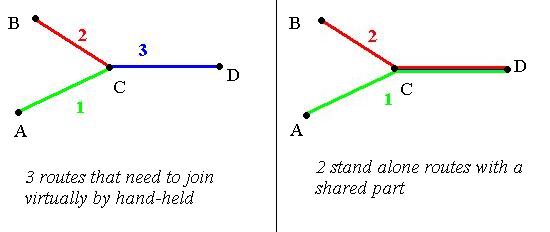
Till now, I create each route separately so I have 2 (or more) routes on the shared section (right). I want to know if I split such Routes at shared section and create a only one route in that part then I'm still able to use routing functions only in 1 stage. (left)

Image

This needs GPS can join virtually 2 (or more) routes but make it easy for me to creating routes specially with long shared part.

I'm not sure if it's possible so I asked if anyone knows. btw I use colorado300 if it matters

User Avatar
Diego Sahagún

 
Posts: 14465
Joined: Sun Oct 07, 2001 6:21 pm
Thanked: 748 times in 682 posts

by Diego Sahagún » Tue Apr 13, 2010 11:04 am

I'm rather new on the GPS word. But what GPS software do you use :?: Would you want to do it in your Colorado :?: BTW, my GPS is a Vista HCx

User Avatar
Moni

 
Posts: 2242
Joined: Mon Aug 12, 2002 11:15 am
Thanked: 4 times in 3 posts

by Moni » Tue Apr 13, 2010 2:13 pm

Routes are basically a series of waypoints that you have linked together into a route (as opposed to tracks). Thus each route is stand alone, but may be composed of waypoints that are common to other routes. The waypoints should appear in your waypoint library. You then decide which ones and in what order to link together into routes. You can reuse waypoints as needed. However, they are straight line linked - you cannot have independent legs, like in the left example.


In a nutshell, the answer to your question is no.

User Avatar
neghafi

 
Posts: 196
Joined: Sat Feb 23, 2008 11:42 am
Thanked: 1 time in 1 post

by neghafi » Tue Apr 13, 2010 3:12 pm

Moni wrote:Routes are basically a series of waypoints that you have linked together into a route (as opposed to tracks). Thus each route is stand alone, but may be composed of waypoints that are common to other routes. The waypoints should appear in your waypoint library. You then decide which ones and in what order to link together into routes. You can reuse waypoints as needed. However, they are straight line linked - you cannot have independent legs, like in the left example.


In a nutshell, the answer to your question is no.

Thanks but I'm not sure if you got me. all waypoints are exists in library. This not a question of "what a route is" or "how to create a route". This is a question about processing capabilities of hand-helds.
Think I want begin from waypoint A to D first and then (maybe after a while) from waypoint B to D and there are more 100 waypoints on section C-D. what I do now is showed on right. to go from A to D I just need Route #2. Exactly the same for going from B to D. Now I have 2 long routes and for each route I have to define (or link) 100 waypoints in section C-D.
Now I would be glad if Garmin GPS automatically detect and use Routes #1 and #3 when I want to go from A to D. and so use routes #2 & #3 to go from B to D. So I just define 3 short routes instead of 2 long routes. I know It's possible to 1st go from A to C and then again go from C to D but I'm not sure if I can ask Garmin to directly navigate me from A to D without mentioning C. In extreme conditions this can help much to go directly from A to D. if this is OK then I have not to repetitiously link 100 waypoints for the next time.
If the answer is NO then I hope Garmin think about it for the next updates ;)

User Avatar
Day Hiker

 
Posts: 3156
Joined: Fri Dec 26, 2003 2:57 am
Thanked: 61 times in 43 posts

by Day Hiker » Tue Apr 13, 2010 3:28 pm

You don't have to "repetitiously link 100 waypoints for the next time." Just make one route A-C-D and copy it, using software if on the computer or using the GPS' menu commands if on the GPS. Then modify the copied route by deleting point "A" and replacing it with point "B."

User Avatar
neghafi

 
Posts: 196
Joined: Sat Feb 23, 2008 11:42 am
Thanked: 1 time in 1 post

by neghafi » Tue Apr 13, 2010 5:51 pm

Day Hiker wrote:You don't have to "repetitiously link 100 waypoints for the next time." Just make one route A-C-D and copy it, using software if on the computer or using the GPS' menu commands if on the GPS. Then modify the copied route by deleting point "A" and replacing it with point "B."

Yes. With "Map Source" on PC it's easy but I'm not sure about doing this easily with a hand held

User Avatar
Day Hiker

 
Posts: 3156
Joined: Fri Dec 26, 2003 2:57 am
Thanked: 61 times in 43 posts

by Day Hiker » Tue Apr 13, 2010 6:27 pm

neghafi wrote:
Day Hiker wrote:You don't have to "repetitiously link 100 waypoints for the next time." Just make one route A-C-D and copy it, using software if on the computer or using the GPS' menu commands if on the GPS. Then modify the copied route by deleting point "A" and replacing it with point "B."

Yes. With "Map Source" on PC it's easy but I'm not sure about doing this easily with a hand held


It's also pretty easy using the GPS. Select a route and copy it using the menu. Then select the first point or points and delete. Then insert new points.

The only way this will be a pain is if you need to delete or insert many points.

User Avatar
TheOrglingLlama

 
Posts: 735
Joined: Tue Sep 30, 2008 6:49 pm
Thanked: 94 times in 56 posts

by TheOrglingLlama » Tue Apr 13, 2010 7:45 pm

Image

:mrgreen:

User Avatar
Moni

 
Posts: 2242
Joined: Mon Aug 12, 2002 11:15 am
Thanked: 4 times in 3 posts

by Moni » Wed Apr 14, 2010 12:11 am

Actually I did get you.

BUT, a Y shaped route is not feasible on any GPS, because GPS, like GIS, can only think in terms of single points, continuous lines of connected points and polygons of connected points, where the last point is linked to the first.

So you want to go from A to C to D: you just create a route that links those waypoints.
If you want to go from B to C to D (or vice versa) you have to create a second route that links those waypoints. Both of these routes have C and D in common.

You cannot have a route that connects (A or B) to C and D. That's not how any current day GPS or GIS thinks. Not even the software allows this: I just tried with Terrain Navigator and it will shows as 2 routes, with C and D as common waypoints. You end up with your right hand illustrated situation.

User Avatar
MoapaPk

 
Posts: 7780
Joined: Fri May 13, 2005 7:42 pm
Thanked: 787 times in 519 posts

by MoapaPk » Wed Apr 14, 2010 12:21 am

I can load a track with branches to my GPS -- I do it all the time. With ExpertGPS, draw a track, then after the track is defined, pick the draw track option again. Put the cursor near where you want the branch, and a "Y" will show. The GPS understands this, and many GPS programs will. But dumb programs (like Nat Geo) will probably send electric shocks through the keyboard to punish you.

User Avatar
Diego Sahagún

 
Posts: 14465
Joined: Sun Oct 07, 2001 6:21 pm
Thanked: 748 times in 682 posts

by Diego Sahagún » Wed Apr 14, 2010 12:29 am

Moni wrote:Actually I did get you.

BUT, a Y shaped route is not feasible on any GPS, because GPS, like GIS, can only think in terms of single points, continuous lines of connected points and polygons of connected points, where the last point is linked to the first.

+1

User Avatar
Moni

 
Posts: 2242
Joined: Mon Aug 12, 2002 11:15 am
Thanked: 4 times in 3 posts

by Moni » Wed Apr 14, 2010 2:04 am

MoapaPk wrote:I can load a track with branches to my GPS -- I do it all the time. With ExpertGPS, draw a track, then after the track is defined, pick the draw track option again. Put the cursor near where you want the branch, and a "Y" will show. The GPS understands this, and many GPS programs will. But dumb programs (like Nat Geo) will probably send electric shocks through the keyboard to punish you.


Yes, I can do that too - on the map it looks like a Y, but it is truly stored as 2 separate tracks - look at the list of tracks and you will see that you have not appended a leg to the track but created 2 tracks.

User Avatar
MoapaPk

 
Posts: 7780
Joined: Fri May 13, 2005 7:42 pm
Thanked: 787 times in 519 posts

by MoapaPk » Wed Apr 14, 2010 2:32 am

Moni wrote:
MoapaPk wrote:I can load a track with branches to my GPS -- I do it all the time. With ExpertGPS, draw a track, then after the track is defined, pick the draw track option again. Put the cursor near where you want the branch, and a "Y" will show. The GPS understands this, and many GPS programs will. But dumb programs (like Nat Geo) will probably send electric shocks through the keyboard to punish you.


Yes, I can do that too - on the map it looks like a Y, but it is truly stored as 2 separate tracks - look at the list of tracks and you will see that you have not appended a leg to the track but created 2 tracks.


Not really. In ExpertGPS, and on the Garmin 60csx, and in the gpx file, it shows up as one track. The simple trick used is this: ExpertGPS divides the track into segments, so that any branch out is defined as a segment, and then there is an identical segment with the trackpoints in reversed order, stitched into the next segment, which is the other part of the original track. The GPX files assigns one track name. If there are multiple branches off branches, the GPX file gets a little bloated, but it is still stored as one track.

User Avatar
Moni

 
Posts: 2242
Joined: Mon Aug 12, 2002 11:15 am
Thanked: 4 times in 3 posts

by Moni » Wed Apr 14, 2010 3:39 am

Okay, I buy into that, but can it do that with routes? I think the intent of the question is to use a stored series of waypoints, to create a multi-segmented route. Not so sure that's feasible.

User Avatar
MoapaPk

 
Posts: 7780
Joined: Fri May 13, 2005 7:42 pm
Thanked: 787 times in 519 posts

by MoapaPk » Wed Apr 14, 2010 3:51 am

Moni wrote:Okay, I buy into that, but can it do that with routes? I think the intent of the question is to use a stored series of waypoints, to create a multi-segmented route. Not so sure that's feasible.


Yes, I agree. I guess the problem is that he is doing this on the fly, but I can't quite figure out why it must be done that way.

Next

Return to General


  • Related topics
    Replies
    Views
    Last post

Who is online

Users browsing this forum: ashbal and 0 guests