The avalanche was several thousand feet wide and ran about 1,200 feet down the Ingraham Direct Route.
Oh shit, I was there a year ago this week.
Wold said she believes the missing person may have been climbing alone.
On Ingraham Direct? Insane.
Climbing, hiking, mountaineering forum
http://www.summitpost.org/phpBB3/
https://www.summitpost.org/phpBB3/avalanche-on-rainier-t53587.html
The avalanche was several thousand feet wide and ran about 1,200 feet down the Ingraham Direct Route.
Wold said she believes the missing person may have been climbing alone.
Brad Marshall wrote:Sad news. Strange that it occurred at 4:45 in the morning at that elevation. Has the area been having weird weather lately?
twoshuzz wrote:I've done the DC a couple of times but not the Ingraham Direct. There's a good amount of big hang'n ice above 12,000 on the ID. I hate to speculate on such things, but I would not be surprised if a large serac toppled and kicked off the slide sending it down the gut of the ID.
Vitaliy M wrote:How is it easier than DC? Just wondering ( I have yet to try either, but have tickets for Seattle for this comming Friday!)
redneck wrote:Brad Marshall wrote:Sad news. Strange that it occurred at 4:45 in the morning at that elevation. Has the area been having weird weather lately?
I dunno, that's just about dawn, when things start warming up.
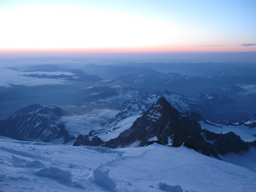
This photo of Little Tahoma was taken almost a year ago at about 4:35am from around 13,000 feet:

Brad Marshall wrote: Has the area been having weird weather lately?
Mountainjeff wrote:Brad Marshall wrote: Has the area been having weird weather lately?
Yes, this spring has been a strange one in the Northwest. There has been above average late-season snowfall that has not been able to consolidate yet. Memorial Day weekend was bad enough to warrant an avalanche warning, which is rare this time of year. I don't think the snow has had time to consolidate since then, plus there may have been more snowfall.
My only surprise was the time at which it happened. I would have expected it to happen in the afternoon, especially with the southern exposure of the route. The temps between Muir and the summit have been reasonably cold to prevent any melting.
http://www.nwac.us/weatherdata/campmuir/10day/
