Page 1 of 1
George Creek Info

Posted:
Thu Mar 08, 2012 12:38 amby TDC
Planning some trips this summer and I am thinking about giving the George Creek bushwhack approach to Mt Williamson a try. I've done Shepherd Pass to climb Mt Tyndall and I try not to repeat a trail just yet. Too much to see. Since I only get two or three hall passes from being suburban dad each summer to go backpacking and peakbagging, I try to explore new areas of the eastside each summer. Anybody been up that way over the past few summers since the restrictions have been lifted? Just how bad (or not) is the bushwhack? I am pretty comfortable with cross country route finding. I went up the Red Lake trail to climb Split Mt last summer. I know that's more 'find-the-trail' than cross country but is the George Creek route similar to the middle part of the Red Lake trail where you need to thrash around and climb the creek for a bit. That is what I am envisioning, just a longer version of it. Any info on your experiences would help. I have found a few trip reports from a few years ago but would like some recent experiences if there are any. Thanks.
Re: George Creek Info
Posted:
Thu Mar 08, 2012 3:23 pmby asmrz
This is what the George Creek upproach looked like some years ago. I understand there is more traffic now, so there is a bit of a trail. But there are still sections of thick willows and low branches that need to be surmounted. It is a wonderful approach to a great peak, go and do it.
Re: George Creek Info
Posted:
Thu Mar 08, 2012 4:42 pmby Vitaliy M.
Restrictions were lifted last year. And I do not think there was much 'traffic' to create a great trail there.
When you start out there is a sand trail on the right and than it is hard to follow much. Although possible. (I been up that way 2ce in the last 2 years, and been there with a person who went up 6 times. It did not seem like being there in the past helps too much, still hard to know where to go).
You basically bushwhack up the canyon and cross the creek when the going gets too tough. Do not go too high up just go up the middle. And don't fall into the creek from one of those huge logs you must cross haha. Maybe this year there will be not much water there due to low snow season. In the spring of 2010 I was pretty scared crossing one of those logs wearing double plastic boots with a raging creek running under me.
Re: George Creek Info
Posted:
Thu Mar 08, 2012 7:45 pmby fatdad
TDC wrote: Since I only get two or three hall passes from being suburban dad each summer to go backpacking and peakbagging...
You know, I really need to start working on my wife. I'm lucky if I get A pass (meaning one) every couple of years or so.
Re: George Creek Info
Posted:
Thu Mar 08, 2012 9:08 pmby Climber Dave
3Deserts wrote:Anyone care to compare and contrast this bushwhack to upper Big Pine South Fork between Willow Lake and Lake Elinore? Thus far, that's my gold standard for complete awfulness.
Thats a sweet approach!! LOL And you can't forget the stream crossings and the skeeters which also add to its fun

Re: George Creek Info
Posted:
Fri Mar 09, 2012 12:07 amby KathyW
The Red Lake Trail is a piece of cake compared to George Creek. I don't remember any "real" bushwacking on the trail to Red Lake.
We went up George Creek in May a few years back - to Trojan Peak for me. I was lucky to be with someone who had been up there before (thank you Harry); so we didn't do much bushwacking. The water wasn't too high; so the creek crossings weren't too bad, but it was still pretty exhausting - it was the heat and the post-holing that made it exhausting. Once you get above 9300' - it's wide open and beautiful; so there is a reward for the hard work.
Last year I tried to go up in June, and did pretty good finding the use trail and the creek crossings again until the second to last crossing (the one where you cross from the north to south side before you get to the last crossing at the Vacation Junction where you cross back over the the North side). The water was running really high and the heavy snow had packed down the willows and other bushes; so they were thicker than on our previous trip. I tried getting across a number of times, but it was too much for me trying to cross the creek and fight the bushes at the same time - a whole different and much scarier experience than the previous trip. I turned back at that point. Later that day, I was pulled over by a state policeman because he thought I was drunk (It had something to do with a u-turn gone wrong). I got out of my truck to do the drunk tests and he looked at my scratched up legs and I had some more explaining to do (a lot of explaining but no tickets). So, don't wear shorts when you head up George Creek, and don't go up there when the water is really high in the creek.
Re: George Creek Info
Posted:
Fri Mar 09, 2012 2:18 amby Ambret
Two friends and I set out to attempt Mt Williamson via George Creek last August. It was pretty much a fiasco. We were way late getting out of the campground at Onion Valley, had to retrace the approach road from Manzanar when we encountered a washed-out bridge, and ended up on the south side of Shepherd Creek before we found George Creek. When we finally got to the trailhead, the creek was running full with snow melt and all over the place. After 30 minutes of thrashing around unsuccessfully -- we could not find the sand trail on the right or anything else that looked even vaguely like a use trail -- we decided it was not to be and wimped out. Hope you have better luck.
Re: George Creek Info
Posted:
Fri Mar 09, 2012 3:17 amby bobpickering
George Creek is by far the worst bushwhack I've ever done.
Re: George Creek Info
Posted:
Fri Mar 09, 2012 5:15 amby jspeigl
George Creek:
More pictures here:
http://www.flickr.com/photos/25345297@N08/sets/72157623933942516/RJ Secor, Peaks Passes and Trails:
Any enthusiastic Sierra mountaineer should climb up George Creek at least once. It is one of the classic bushwhacks of the High Sierra.
Re: George Creek Info
Posted:
Fri Mar 09, 2012 7:19 amby Vitaliy M.
Anyone care to compare and contrast this bushwhack to upper Big Pine South Fork between Willow Lake and Lake Elinore
LOL!!!!!
Would you guys want a drawn topo of it too?
Just go out there and find your way. It is not that bad really. It sucks for some bits, but it isn't all that bad honestly. Far from being a civil trail, but very doable. Do not think about it too much, and do not worry about what people say in this thread. It is not as bad as one would imagine from reading everything online. BUT SF of Big Pine between Willow and Elinore do not compare.
Re: George Creek Info
Posted:
Fri Mar 09, 2012 6:52 pmby jspeigl
The topo is somewhat like this:


Re: George Creek Info
Posted:
Fri Mar 09, 2012 7:05 pmby jdmorris
3Deserts wrote:Anyone care to compare and contrast this bushwhack to upper Big Pine South Fork between Willow Lake and Lake Elinore? Thus far, that's my gold standard for complete awfulness.
I haven't been up George Creek, yet (planning on it this summer) but I wouldn't consider South Fork Big Pine a bushwhack to Elinore. A mosquito infested mess near Willow Lake, sure, but it would qualify as a well traveled trail in the Cascades and the route finding is fairly trivial [edit - I just read 3Deserts's post and it's clear I found something much easier] . It's been a while since I hiked to Red Lake, but I glanced back at my pictures and I don't remember anything that would qualify as bushwhacking. They're probably both BW0 to BW1. My expectation is that George Creek is more of a BW3, albeit brief. Maybe it's a semantic difference between "hiking cross country off trail" and "bushwhacking", where the latter implies to me that I'm either bleeding or swearing.
Older feedback on those ratings, here:
http://www.summitpost.org/phpBB3/bushwhacking-ratings-t48102.htmlJD
Re: George Creek Info
Posted:
Fri Mar 09, 2012 7:26 pmby Bob Burd
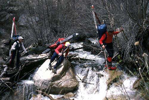
Everyone's experience is going to be different. The route up George Creek changes from year to year with new downfall, avalanches and periodic flooding. I've been up it four times and each time it felt different, but it was always good fun. The picture of the guys carrying skis up there did not appear quite so fun. There's a lot of ducking under branches and stuff and skis would make it more frustrating, to be sure. It's not dense stuff like you find below Elsinore or the Red Lake Trail (if you lose the trail), more like old forest undergrowth with lots of logs and debris piled everywhere, along with steep rocky slopes encroaching one side of the creek or the other - much more pleasant, really. As someone already said, you start on the north side, follow along until blocked by a cliff, then switch to the other side. Five crossings is all it should take to get you past the forested section and over to the south side that you then follow up most of the remaining distance.
Re: George Creek Info
Posted:
Fri Mar 09, 2012 7:40 pmby Vitaliy M.
That's not what I was asking about anyway. I can find my way well enough smartass. It's just that some of us don't have the privilege of being 25 anymore and being able to do this on a whim. We've got families, high-strung careers, and other major crap to deal with which only means that on the breaks we DO get to get out in it, it kind of matters to try to not have every weekend end in failure because you simply ran out of time trying to get through a bunch of shitty willows because you HAVE to be back no matter what, rather than getting up above tree line where at least you can see something other than thickets so even if you don't make the peak there's still some aesthetic take-away value. That's all. There are section of the SF BIg Pine that are miserable and slow, and it's got NOTHING to do with route finding. Just having to push your way through awful, dense undergrowth where mileage/time drops through the floor.
Hey, I have a high-strung career, am in the middle of getting OWN place, and do have a family. Do not assume that I am unemployed 25 y/o with all the time in the world on his hands. I make time to get out, and it is in my priorities because I enjoy it.
If you can find your way 'well enough' than why ask? Start early and go up it. It is hard to explain the correct way up ''bunch of shitty willows," just follow the path of least resistance and cross the creek to the other side when the going gets tough. Bob Burd's TR about going up it is more than enough.
What exactly is so funny about that
It is funny you asked to compare SF of Big Pine creek to it. SF of BP is not bad at all, unless you were off route there.
Re: George Creek Info
Posted:
Fri Mar 09, 2012 9:53 pmby Vitaliy M.
I have been up both. Twice.
Let's do a little remedial work. I never said:
"oh, do you want a map to help you since you SEEM to be too fearful to be a gnarlyman and just get out there and DO IT?"
I did laugh at your request for comparison between the two because SF of BP did not come across as annoying bushwhack to me at any point. Now I see you refer to one specific part you went down on the way back. I am not familiar with that part I guess. I do not like following people down bush whack ways.
Really happy you been reading topos for as long as I been alive. Too bad you do not appreciate smart-ass comments. Sometimes they pop up, especially on the internetz. : )