Page 1 of 2

Sawtooth Range

PostPosted: Mon Apr 23, 2012 11:50 pm
by DrGranola
Anybody been up there? Anyone know anything about the trail, snow conditions and/or stream crossings? I'm wondering about the west side trails, from Grandjean. Baron Creek trail, to be more specific.

Thanks!

Re: Sawtooth Range

PostPosted: Tue Apr 24, 2012 1:05 am
by climbinmandan
http://www.sawtoothcamera.com/fullsize.html

As you can see, the snow level is still pretty low. Doable if you have the right gear though.

As for creek crossings, they are pretty high and swift right now. Be careful.

Are you planning on climbing anything?

Re: Sawtooth Range

PostPosted: Tue Apr 24, 2012 4:20 am
by DrGranola
Yeah I know all that. Was just wondering if anyone had been up there. Just looking to get up to a lake or something to take the GF on an overnight hike. I figure it will just have to wait for a while...

Thanks!

Re: Sawtooth Range

PostPosted: Tue Apr 24, 2012 5:35 am
by splattski
The problem with the east (Stanley) side this time of year are twofold:

1. The snowmobiles pack snow on the roads all winter. The packed snow melts slower, so often times the surrounding terrain is bare while the road has a foot or two of snow. So you have to park on the highway and ski in. And that means both lakes and peaks are too far away for an average day hike.

2. Even after the roads melt out, the FS will mark them closed. All of them. You might see others driving on these 'closed' roads, but if you go past the Closed sign you risk a BIG ticket. Those are the words of experience- I drove on dry pavement to Redfish Lake and parked in the hiker's parking lot, also dry. Came back to a huge parking ticket- even though there were folks camping behind the closed sign.

However, the trail up to Baron will melt out early. I climbed Baron in late May, following tracks up high that were two weeks old (left by a friend). So THAT might be open real soon. Go try it and give us a report. Here's my TR:
http://www.splattski.com/2007/baron/index.html

Re: Sawtooth Range

PostPosted: Tue Apr 24, 2012 5:59 am
by DrGranola
Thanks splatski! I'm hoping to go scout on the west side real soon to see what can be done, as far as getting the GF up to a lake soon. Maybe trail creek? Snotel sights are looking pretty deep, with above freezing temps at night, and with the weather outlook for the days I have available, it probably wont be this week. Although, Baron does look pretty great and have that on the 'list' now! I usually don't do much in the Sawtooth's until July. I've had a decent share of super sketchy creek crossing, 'skeeters, ect...

Re: Sawtooth Range

PostPosted: Mon May 07, 2012 10:18 pm
by agb
Hey all. I'm planning a trip to the Sawtooths in mid-June this year and had a couple of questions about snow and routes.

What is the snow likely to look like next month? What about stream crossings? We'd like to climb Braxon, and I know we're headed up there early, but I was hoping the snow would look like splatski's trip report in June of '07 (http://www.splattski.com/2007/braxon/index.html sweet site, by the way). What are my chances that snow won't be an issue?

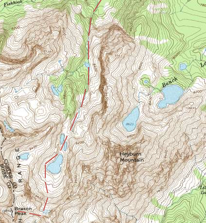
Also, I've been playing with the idea of doing it as a loop from Fishhook creek, starting on the basic route to Horstmann, but staying in the eastern drainage and continuing to the cirque just west of Heyburn, then climbing south up to the saddle that connects to the ridge to Braxon. Then descending into the Redfish Lake Creek valley and taking the boat back to the lodge.

If that doesn't make sense, here's a picture.

Image

I'm just not sure about the portion of the hike where it separates from the Horstmann route. Has anyone been up there? Am I right in assuming I can get up to the basin west of Heyburn without anything more than class 4 scrambling? This photo http://static.panoramio.com/photos/1920x1280/39885874.jpg makes it look like the saddle is pretty accessible from the basin. I guess I'm really asking about the middle third of the route above.

Any ideas, comments, ridicule, etc. would be really helpful. Thanks!

Re: Sawtooth Range

PostPosted: Wed May 09, 2012 1:52 am
by splattski
Gorgeous photo!

I've heard lots of people complain about the bushwhacking in upper Fishhook Creek, most of them only trying to get to the Sickle Couloir. So you might be in for some thrashing.....
SuperDave (here on SP) hiked down Fishhook Creek from Baron Lake.
http://idahoalpinezone.com/index.php?p=2_57

The saying for the Sawtooths is "You can't go high 'til the 4th of July". In other words, expect some snow. We did some serious potholing, but only because we were traveling in bright sun in the afternoon. Hit it early and you can usually move pretty well. Crampons and maybe an axe?

I don't think you'll have too much issue with creeks on your route.

I have not been all the way up that drainage, but I know someone who has skied your proposed route in reverse, so I think it will go (remember: free advice is worth what you paid for it).

Let us know how it goes.

Re: Sawtooth Range

PostPosted: Mon May 14, 2012 10:19 pm
by agb
Hmm...after reading that trip report, maybe we'll do the loop in the opposite direction, and hike down Fishhook instead.

Thanks for the help.

Re: Sawtooth Range

PostPosted: Fri Jun 22, 2012 12:48 am
by DrGranola
After all the talk about being a 'high tick year' I didn't see any on the Baron Creek trail. Flying bugs were not too bad ether.

Re: Sawtooth Range

PostPosted: Sun Jun 24, 2012 10:56 pm
by splattski
Looking for trip reports from both agb and DrGranola......
C'mon, fellers, feed our need!

Re: Sawtooth Range

PostPosted: Mon Jun 25, 2012 11:13 pm
by DrGranola
Not much to report from me. Got to Grandjean at 7 and was jamming down the trail at 730. It went from 34*f to 84* in about an hour and a half. Reached Moolack creek with minimal effort. Finding a way up the canyon, however, was quite the challenge. I didn't make it up too far at all so I hiked to the drainage to the east and thought about giving that a try but there was still quite a bit of snow in there and decided against it. I hiked back to Moolack Ck and tried once more to find a "passable" area but was without success. Made it about 600ft up the west ridge and ran out of time. My juju was off... Planning on giving it another try before too long.

Re: Sawtooth Range

PostPosted: Tue Jun 26, 2012 2:21 pm
by BeDrinkable
Have you been up Baron before Doc? It took me three tries (over about 7 years) before I made it. I passed Moolack creek the first time, tried the ridge and got cliffed the second. The navigation on that one, not to mention the bushwacking, is a challenge.

Re: Sawtooth Range

PostPosted: Tue Jun 26, 2012 3:03 pm
by DrGranola
No, this was my first try. It seemed so close, yet so far away!

Re: Sawtooth Range

PostPosted: Thu Jun 28, 2012 10:40 pm
by agb
splattski wrote:Looking for trip reports from both agb and DrGranola......
C'mon, fellers, feed our need!


There's not much to report, sadly.

After arriving in Stanley and getting a look at the snow, we decided to do something a little more obvious. We ended up hiking up to the Baron Divide, and getting as close to the top of Peak 9510 (up the ridge directly north of the divide) as I could. I thought it looked like a nice little high point on the topo map, but turned around 50-60 feet from the top when I reached the class 4-5 stuff on the summit block. I only looked at it from the south side, so there might have been a way to scramble around and up. Since getting back, I haven't found any evidence that anyone has ever been too interested in climbing it, though.

If you're ever on the Baron Divide, I would suggest going uphill (north) a little bit, for a sweet view of the Mayan Temple that you don't get from the saddle.

Anyway, there was a fair amount of snow in the Alpine Lake basin -- no lake to speak of, just a big icefield and there were giant cornices hanging off of the ridgetops off Packrat peak. This was two weeks ago, so...I'm probably not any help to someone planning a trip now.

Thanks for the advice, even though I wasn't able to use it. Hope I have a chance to sometime in the future.
Re: Sawtooth Range

PostPosted: Thu Jun 28, 2012 11:10 pm
by splattski
Sorry to hear on both accounts (Baron and the Fishhook loop). But probably really beautiful days, regardless?

So the ol' folk saying came true this time. It'll dry out in just a few weeks.

Uphill from Baron Divide takes you into the basin from which you climb Warbonnet. I've been over that pass:
http://www.splattski.com/2007/warbonnet/index.html

Thanks for the TRs!