Page 1 of 3
Okay, I have given up on Nat'l Geographic's TOPO! software

Posted:
Thu May 13, 2010 8:59 pmby simonov
I have been wrestling with this software for years, but today I am forced to admit I am throwing in the towel. You win, National Geographic, your software is officially unusable.
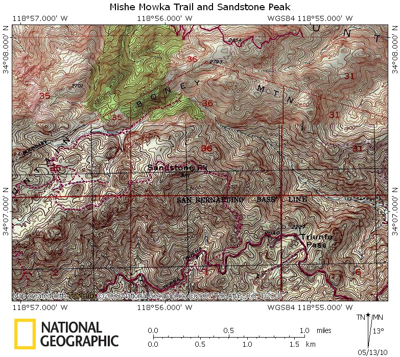
It has always been difficult to use, but now I have lost patience with the extremely poor image quality and resolution of the maps. They are supposed to get their data from USGS topo maps, but the unreadable crap above (of an area in the Santa Monica Mountains) doesn't look like any USGS topo map I have ever seen. There are a few trails in there I am supposed to attempt to trace with their path tool. They must be joking. Who the hell can see the trails in this mess?
And, yes, that's the best resolution I can get. No way to zoom in any farther. Maybe I could, with a lot of effort, trace a trail with my eyes from 20 years ago, but not now.
The maps have always looked like crap. The maps in my Flickr photostream have been tarted up considerably in Photoshop before I uploaded them. But here I decided to show exactly what the maps look like before they are cleaned up. Garbage.
So I am now looking for an alternative. All I want is map software with:
o topo data;
o the ability to trace, import and export GPS tracks;
o export to JPEG; and
o maybe an elevation profile jobbie.
I've seen some folks using different software from time to time. Anyone have any suggestions?
Posted:
Thu May 13, 2010 9:12 pmby Dave K
I'm not that impressed with their printed maps either. Last month I bought their map of Joshua Tree NP, which omitted an obvious and still useable backcountry road. When we encountered the road while hiking, the omission caused us some navigation confusion. Maybe they got bad data from the govt., but regardless, they need to fact check their products.
Nat. Geo. should be setting the standard for good cartography, not churning out crap. To me that omission makes the whole map unreliable.
Posted:
Thu May 13, 2010 9:28 pmby Luciano136
I like them, even though the image quality isn't the greatest. I usually use max zoom and then multiply the view by 2. That makes it pretty easy to trace trails and see landmarks. I have used it many, many times to creates routes and upload them to my GPS.
Posted:
Thu May 13, 2010 9:30 pmby Buz Groshong
Dave K wrote:I'm not that impressed with their printed maps either. Last month I bought their map of Joshua Tree NP, which omitted an obvious and still useable backcountry road. When we encountered the road while hiking, the omission caused us some navigation confusion. Maybe they got bad data from the govt., but regardless, they need to fact check their products.
Nat. Geo. should be setting the standard for good cartography, not churning out crap. To me that omission makes the whole map unreliable.
What they are selling is just USGS topo maps in a digital format along with some software that can be used with it. Any company that tries to fact check the data and then sell the product will lose their shirt. I've found most of it to be very usable here in the east, although it does not have all of the trails on it (they do have a place on their web site where users can upload data for trails).
Posted:
Thu May 13, 2010 9:35 pmby Castlereagh
What are people's thoughts on those big red DeLorme book atlases? Not quite a topo map for trails, but are they good for backroads?
Posted:
Thu May 13, 2010 9:49 pmby Dave K
Actually I think I might do that.
Edit: well, the road appears on the topozone topo map. So why not Nat. Geo.?
The trail we followed was new: the Nat Geo map has the trail but not the road. Topozone has the road but not the trail. So I think the topozone map is likely older but accurate during its time, but the Nat Geo map, which is newer, shows the recent trail but omits the road.

Posted:
Thu May 13, 2010 10:04 pmby Mountainjeff
I am not overly impressed with the National Geographic software either. Aside from the map quality, the actual program does not work very well. I prefer my 12 year old version of Maptech. I cannot vouch for any newer software.
Posted:
Thu May 13, 2010 10:06 pmby woodsxc
Nat Geo Topo software has been used successfully in the woodsxc domicile for years. No problems with it thus far.
Posted:
Thu May 13, 2010 10:06 pmby mrchad9
I agree with most of the others. I've always found the software to be very reliable, at least the CA one which I use extensively. There are a few areas where the hills are low and the countours can be hard to read, but they are still just as easy to read as the USGS maps. Since it is just a copy of those maps, can't expect too much more.
Sometimes there is a road or trail that may not be on it, but it isn't on the USGS Quad either.
Posted:
Thu May 13, 2010 10:19 pmby SoCalHiker
I use that software for years and like it very much. I agree that some areas suffer in quality but overall I am very happy with it. I actually mapped my hike up Sandstone Peak (direct via Backbone or via Mishe Mokwa) a few months ago with this software.
Posted:
Thu May 13, 2010 10:26 pmby Smoove910
To me it looks like you need to zoom in more.
Posted:
Thu May 13, 2010 11:06 pmby ZeeJay
The old style 7.5 min topo maps that came preprinted were much better quality than what you get in TOPO!. However, the last time I tried to purchase one, they did not have it in stock and printed it up for me and it was the same lousy quality of TOPO!. The clerk said that that was just the way it was and they didn't supply the originals anymore. However, the paper stock was a much better quality, and was made to last (even appeared to be waterproof), but I didn't like that either because it was considerably more bulky and heavier. My guess/fear is that eventually all topo map suppliers will go this route because they won't have to maintain any stock and will be able to supply any topo map for the whole US instead of just carrying ones of local interest.
As to which trails/roads show up in TOPO!, any that are on the quad should show up. Where I live, there are lots and lots of trails that are not on the original quad map and hence not in TOPO!, but that is not TOPO!'s fault.
As to clarity, I think it is improved when you turn shaded relief off. It looks like you might have it on in your sample map.
I personally love TOPO! and think it interfaces well with GPS use.
However, I definitely miss the crispness of an original paper quad map.
Posted:
Thu May 13, 2010 11:12 pmby OOG
Castlereagh wrote:What are people's thoughts on those big red DeLorme book atlases? Not quite a topo map for trails, but are they good for backroads?
Hit and miss. The Oregon Atlas has all forest road labeled and current, while the Northern California atlas shows dirt roads and trails as the same dashed red line, with no labeling. Best bet is to thumb through one before purchase.
Here's what I use for topos, nothing fancy but I like the simplicity.
you can save image files and print them or edit them as needed. Also it's free.
http://www.digital-topo-maps.com/
Posted:
Thu May 13, 2010 11:16 pmby mrchad9
ZeeJay wrote:However, the paper stock was a much better quality, and was made to last (even appeared to be waterproof)
That paper is definitely great quality. It lasts a long time. I've had some go through the wash and drier and, though faded, still perfectly usable.
ZeeJay wrote:but I didn't like that either because it was considerably more bulky and heavier.
that and the cost of the waterproof paper is why I now rarely use it. Only if it is an area I know I will be returning to regularly or if I am really concerned about it getting wet.
Posted:
Fri May 14, 2010 12:23 amby Bob Sihler
Castlereagh wrote:What are people's thoughts on those big red DeLorme book atlases? Not quite a topo map for trails, but are they good for backroads?
Mine for MT, UT, and WY have been good.