Page 10 of 13

PostPosted: Thu Apr 08, 2010 2:10 am
by Ed F
Went up Short Swing in Mill D North first today (west-facing trees from the two 9000 ft. bumps between Mill D North and Beartrap), and it skied great with really nice powder. Then, we headed over to Reynolds to ski the North Reynolds trees. Surprisingly, the snow was pretty wet even though it faces mostly north. We headed back to Short Swing for two more laps in the trees. By 3pm, almost everything was getting pretty wet, especially lower. The sun cooked everything all day today. There will be a crust on east, south, and a lot of west tomorrow.

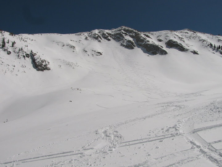
I saw a lot of wet snow activity today, including the Catcher's Mitt on Kessler, Reynolds' Northeast Bowl, most of the east-facing stuff in Cardiff, and Reynolds' east face. With all the new snow and the wind-loading with this last storm, people were mostly staying out of the steeper terrain today. I saw the results of a pit on Short Swing, and you can really see that dirt layer in the snow very clearly now. It's buried under 2-3' of snow now, so it might create some interesting things during corn season when it reappears. This storm threw the snow around in every direction, creating lots of cornices, wind features, and strange layers in some places.

Mid-elevation sheltered trees were the ticket today. Last big powder day of the year? I hope we get at least one more shot.

PostPosted: Thu Apr 08, 2010 5:31 am
by TyeDyeTwins
Observation April 7 Went up to Tri County Peak for some safe blower powder skiing today. Heard a massive whooomph while skinning up to the peak. Got 7 laps on the main west facing run until some law breaking snowmobilers came over and ruined the fun. Saw several large powder avalanches in Solitude's Honeycomb Canyon. These were the result of control work with explosives. The more intresting avalanche today was on Park City Mountian Resort's Pinecone Ridge. This large explosive triggered avalanche was around 2 feet deep and occured on a southeast facing slope around 9,800 feet. It was no suprize to us that this slope avalanched. Troy and I started an avalanche there a couple years back and have since then considered the area a frequent avalancher.
The 1st picture is of the avalanche on PCMR's Pinecone Ridge.
Image

PostPosted: Fri Apr 09, 2010 4:38 am
by TyeDyeTwins
Observation April 8 Went up to Peak 10,420 today hoping to find some soft spring powder that had not been affected by the warm temps from yesterday. Skied the steep northeast facing trees and found out that the 4 feet of new snow from Monday had setteled to around a foot of mixed powder/suncrust. By 4pm we were at the summit again and skied down the Northwest Trees which were already wet. Powder is becoming a thing of the past below 11,000 feet. No new avalanche activity was found or heard of today, however I did get a better picture of the avalanche on Pinecone Ridge from the summit of Peak 10,420.
The 1st picture is of the avalanche on Pinecone Ridge.
Image
The 2nd picture is of Troy skiing soft powder above the Northeast Trees
Image

PostPosted: Sat Apr 10, 2010 3:12 am
by TyeDyeTwins
Observation April 9 Went up to Wolverine Cirque via Grizzly Gulch and skied The Bronco Couloir to Figure 8 Hill. Just before dropping in I caught a glimps of the large avalanche crown on Monte Cristo. Skinning back up the popular route to Twin Lakes Pass was like climbing in a boulder feild because of all the avalanche debries everywhere. Decided to continue on past the pass to the summit of Patsy Marley again. Dropped into the west face (aka The Gut Shot) at 4pm. Made a series of slope cuts until the "gut" part of the run was reached. Made about 15 turns in and saw tons of roller balls coming down behind me. I skied away from the gut and off into a patch of trees. From the trees I watched the rollers get bigger and then break, over and over again. Also from the trees I could here all the people at Alta Ski Resort yelling avalanche. After about a minute of seeing no more activty I continued skiing down "The Gut Shot" using a series of small sub-ridges, slope cuts and safe spots. At the bottom there were 4 people who saw the whole event take place. They asked if anyone was caught in the avalanche and I assured them that I was skiing alone and that it was not even big enough to burry someone. Today was a great example of why when skiing in the Wasatch Range you have got to "Wasatch Your Back", especially during spring time.
The 1st picture is of the class 3 avalanche on Monte Cristo
Image
The 2nd picture is of the avalanche crown in Silver Fork's Meadow Chutes
Image
The 3rd picture is of the small avalanche (look for all the brown snow) that I triggered on Patsy Marley's "The Gut Shot"
Image

PostPosted: Mon Apr 12, 2010 5:02 am
by TyeDyeTwins
Observation April 10 Went up to Peak 10,420 yesterday. Skied a couple of laps in the usual steep places without so much as a sluff. The winds by 7pm were starting to get into the 40+mph catagory, creating an obvious wind pillow on a roll over just off the main peak (which was easily avoided).
Skiing powder at 7:30pm.....it must be spring time already
Image

PostPosted: Mon Apr 12, 2010 5:15 am
by TyeDyeTwins
Observation April 11 Went up to Mill B South to Lake Blanche today. The temps were so warm the night before that there was no such thing as a refreeze making the snow conditions really reallly wet out there. Saw a glide crack that had moved and then stopped on the Mill B South Super Slab. By the end of the day several more glide cracks opened up that were not there in the morning. At the lake the winds were blowing in the 40+mph catagory. A large natural avalanche was seen just north of the Dromedary Shoulder. The avalanche was most likely a wind slab that was the result of a cornice fall quite some time ago. Even more interesting is the fact that it stepped down into a deeper layer in a few spots. The lack of a refreeze, high winds and a large natural avalanche forced us to ski the low angled terrain off of the lake and call it a day.
The 1st picture is of the large natural avalanche near the Dromedary Shoulder
Image

PostPosted: Fri Apr 16, 2010 9:08 pm
by TyeDyeTwins
Observation April 14 Went up to Peak 10,420 on the 14th. While breaking trail up the north ridge we triggered a shooting crack on a stiff wind drift. Got several laps in the steep Northeast Trees along with the NW trees with no incident.
The 1st picture is of the shooting crack on the north ridge
Image

PostPosted: Fri Apr 16, 2010 9:09 pm
by TyeDyeTwins
Observation April 15 Decided to branch out and go to Cartiff Fork since the Wasatch Powder Pigs.....oh wait Birds, are done for the season. Skied down the "Eyebrow". It was crusty as hell and was full of wet debries. I saw a couple of skin tracks up Cardiac Ridge with no ski tracks, so I took advantage. Around 9am I got 1st and only tracks on Cardiac Ridge. By noon I found myself on the Mount Superior ridgeline again. Decided to ski what is known by UDOT as "Two Trees". The south facing was a little wet but the west facing aspects were perfect corn all the way down. The only real avalanche activity seen out there (other than the UDOT explosive triggered 1's) was on the Lightning Bolt Apron. It appeared to be grauple avalanche due to the location (far down on the apron) but facets may have been a factor.

Either way this shows that there is still an isolated risk of triggering an avalanche out there. Because the Utah Avalanche Center is done forecasting for the season I thought I would take a stab at it. I would call the danger LOW on West, South and East facing slopes until the afternoon temps get too warm. For the highest and most extream Northerly Facing slopes I would say there is stilll an isolated pocket or 3 somewhere in the Wasatch waiting for a trigger. This would dictate POCKETS of MODERATE on the steep, sheltered, northerly facing terrain, above 9,500 feet.

The 1st picture is of the avalanche on the Lightning Bolt Apron
Image

The 2nd picture is of my track on Cardiac Ridge
Image

The 3rd picture is of my route down "Two Trees" on Mt Superior
Image

PostPosted: Mon Apr 19, 2010 7:29 pm
by TyeDyeTwins
Observation April 18 Went up to Box Elder Peak with the intentions of skiing the Northwest Cirque off of the summit. When we reached the lower meadow just before the steep North ridge a member of our party felt/heard a huge whooomph. While breaking trail up to the ridge several more whoomphs were heard/felt by more of our group members. After the 5th whoomph we dug a snowpit on a north facing, 38 degree test slope at about 9,000 feet to check things out. We found that the overnight temps (35F) were cold enough to freeze the upper 3 inches of the snowpack, but just below the freeze crust was 6 inches of wet "snowcone" type snow. On the 3rd shoulder tap we got a clean shear which was somewhat concerning.

We continued on up until we reached the top of the north ridge. We decided that because of the warm temps to ski the Shot Gun Chutes insted of Northwest Cirque. Skied both Shot Gun Chutes all the way down Dry Creek Canyon. Got a small wet slab to pull out off of one of east facing gully side walls. Much like our snowpit showed, the wet slab it failed about 3-6 inches down and was about 30 feet across. We also sent down lots of roller balls, one of which was the size of a small car when it finally stopped moving. The snow line was patchy at 6,000 feet but we were still able to ski down most of Dry Creek Canyon.

I would call the avalanche danger MOSTLY LOW in the morning with pockets of MODERATE by late afternoon. However on nights where there is not a decent refreeze (+32F) the avy danger could easily reach pockets of CONSIDERBLE for Wet Slabs late in the afternoon. This is not an average Wasatch year snowpack wise so keep digging snowpits and check the overnight temps before getting out on anything too extream. Low and mid elevation slide paths such as Gobblers Knob and Coalpit #4 are examples of areas where you should be on the look out for avalanches of this nature.

The 1st picture is of our tracks on both of Box Elder's Shot Gun Chutes
Image

The 2nd picture is of Troy crossing one of many rivers in Dry Creek Canyon
Image

Conditions 4/22/2010

PostPosted: Thu Apr 22, 2010 11:33 pm
by vanman798
Did anyone get out today? Just wondering how the avy conditions were. thx

PostPosted: Thu Apr 22, 2010 11:53 pm
by JLarsen
I am also curious as to how much snow fell at elevation. Seeing as a few of us are doing Lone Peak this weekend, I think it would be useful information.

PostPosted: Fri Apr 23, 2010 6:56 am
by TyeDyeTwins
Observation April 22 Went up to Catherines Pass and Point Supream today. Found only an inch of new snow from the recent storm. In a few wind loaded/cross loaded gullies around 11,000 feet I found up to 4 inches. Skied plenty of slopes at 45 degrees and was only able to get the new snow to roller ball. Dug a snowpit and found out that the temps have been cold enough lately, finally diminishing the wet slab danger/concern out there.

The only real avalanche activity worth mentioning was in the south facing couloirs in Little Cottonwood Canyon. Tanners Gulch, White Pine Couloir, Limber Pine Couloir and the Jebidia Couloir all had impressive wet debries that were more than capible of burring a person or two. Also of interest there were some large wet slides in the Y-Couloir and The Coffin Chutes (near the Snowbird boundry). It should be noted that all of these avalanches occured before monday during the heat of the afternoon.

Overall I would call the danger MOSTLY LOW as far as new snow avalanches are concerned. However with the heat of the afternoon the danger of triggering a wet avalanche (the point release type) could easily rise to MODERATE in the confined couloirs around the Little/Big Cottonwood Canyons. As far as Saturday's avalanche forecast is concerned it will all depend on how much snowfall/wind there is with tomorrow's storm. We are planning on touring tomorrow during the storm so we will keep you posted on how this storm actually pans out.

The 1st picture is of the wet debries pile in the Limber Pine Couloir
Image

PostPosted: Sat Apr 24, 2010 4:48 am
by TyeDyeTwins
Observation April 23 Went from Pinecone Ridge to Peak 10,420 today. Skied Homelite off of Pinecone Ridge and when we reached the bottom we dug a snowpit at about 8,000 feet. We found that the storm cycle started out as rain but the past couple of nights have been cold enough to refreeze the snowpack together. We skinned up Thanes Canyon and then up Shadow Ridge to the summit of Tri County Peak. While skinning up Shadow Ridge we got several large and scary shooting cracks around the skis on just about every wind drift. Decided to skin up to the summit of Peak 10,420. While skinning up the north ridge Peak 10,420 several sensitive wind drifts up to 8 inches deep were encountered. Skied the northwest trees off of summit. By the end of the day anywhere between an inch to 4 inches of new snow fell over the day.

Overall I would say that the avalanche danger is MOSTLY LOW at the lower elevations, with the avalanche danger increasing with elevation. Above 9,500 feet in wind loaded areas I would call the danger a solid MODERATE of triggering a new snow windslab.

If you are planning on Lone Peak tomorrow it would be a good idea to use safe route travel techniques, give the cornices extra room, dig some snowpits and watch for the warning signs of a windslab (shooting cracks, whooomphs, smooth rounded pillows that feel hollow ect.....) Remember the danger of a windslab tomorrow on windloaded slope is a solid MODERATE, and people have lost their lives to avalanches in the past on moderate days.

The 1st picture is of the most visibility we had all day long.
Image

PostPosted: Tue Apr 27, 2010 2:37 am
by TyeDyeTwins
Observation April 26 The two of us went our seperate ways on Sunday. I went up to Alta and skied East Castle. Found some wind drifts that were up to 8 inches deep. Because of the previous days warm temps, all the wind drifts found were pretty well welded in place. From the top of East Castle I got a good look into American Fork Canyon. I was only able to find 1 significant avalanche out there. It was in Mill Canyon Peak's "Shaffer Fork Chutes" and was one of the larger point releases I have seen on that peak in quite some time. The avalanche appeared to knock down and burry serveral good sized pine trees and most likely ran because of afternoon heating (making this one easy to avoid).

Troy headed up to Gobblers Knob and skied Cabin Run into Porter Fork. The wind drifts were not as deep as the ones found in the upper Cottonwood Canyons. However a recent Wet Slab that was up to 3 feet deep was observed in Mount Raymonds "Paradise" (a steep north facing bowl inbetween 10,000 and 9,000 feet that is very popular with heli skiers). This Wet Slab was the most likely the result of several days of warming + water running on the rocky bed surface + a cornice fall for a trigger (much like a glide avalanche).

Overall I would call the avalanche danger mostly LOW for the Wasatch right now. Tonights refreeze will be marginal so an early start to the highest elevations would be a good idea for tomorrow. Because of the Wet Slab seen in Porter Fork I would still say there is an isolated risk (MINY MODERATE) of triggering one of these "wet slab avalanches" in the low to mid elevation avalanche paths (below 10,000 feet), especially in release zones that have a rocky bed surface. Every year in the Wasatch we usually get full depth wet slab/glide avalanches around late April through mid May in places such as Gobblers Knob (Cabin Run), Mineral Fork (Room of Doom) on the Park City Ridgeline (Scotts Bowl), Stairs Gulch and Broads Fork. With the weather forecast calling for possible snow levels reaching the valley floor later on this week this avalanche concern will likely diminish, until we get another prolonged warm spell.

The 1st picture is close up of the wet slab in Mount Raymond's "Paradise".
Image

The 2nd picture is of Mount Raymond's "Paradise" with the wet slab on the left.
Image

PostPosted: Tue Apr 27, 2010 4:19 pm
by WhitePine
Descended Red Baldy on Saturday. Everything was pretty much frozen solid at the time except the top few inches. I'm sure things have softened up significantly since then.

Image