Page 3 of 13

Posted:
Mon Jan 04, 2010 4:08 pmby Ed F
Skied almost all aspects of Reynolds yesterday (1-3-2010). Still the same out there: slopes that have slid have refilled with mostly stable layers, but the slopes overlying the depth hoar from early December are still nasty. I haven't been out as much lately because of house guests, but things seem to be getting more stable, and skiing conditions are excellent on slopes that don't get a lot of sun.
Posted:
Tue Jan 05, 2010 5:42 pmby marauders
Cool site. Nice gathering of info.
Posted:
Tue Jan 05, 2010 10:32 pmby Ed F
A nine-day trend of the Avalanche Rose. Great link.
http://utahclimbers.com/misc/avy9daytable.php
Posted:
Sun Jan 10, 2010 5:45 pmby seanpeckham
Went to Cardiff Pass from Alta yesterday, and skied short laps in upper Cardiff east of Cardiac Bowl, NW-, W-, and E/NE-facing, angles approaching upper 30s, and then returned by skiing the SE face of Cardiff Peak. In a handpit just off the pass on the NW aspect, I got a Q2 shear a few inches below the surface, and a Q3 one about half a foot below that, and nothing else. This top layer would produce minor cracks when traveling but was otherwise unreactive to skiing. Found a surprisingly homogenous and strong snow structure all the way to the ground (120 cm deep just off the ridge, probably less farther down) on the N/NE-facing side of the ridge that runs north into Cardiff from the prominence just west of Cardiff Peak. Some areas, near rocks and ridgetops, had a much thinner snowpack which felt weak at the bottom with hard enough pole probing to penetrate the stronger snow above, which did not feel sensitive to my weight. However, across the canyon we saw an avalanche on Mt Baldy released by control work, and saw where several other recent results had been obtained there.
The snow was very nice dense creamy powder or settled powder on all aspects except S and SW, which had a sun crust.
In conclusion there were pockets of moderate hazard for cameras rolling all the way down the slope and considerable danger of core shots.
Posted:
Sun Jan 17, 2010 4:19 amby marauders
Up on Gobbler's today, skied SE and E. Above 9,600 all was crusted with a brittle 1-inch crust, underneath was pure facets. Could be a problem with new snow. Below that elevation, in less wind affected terrain, was great recrystallized powder. The turns were mostly smooth and soft with the occasional wind/sun crust. Surprisingly fun day considering the lack of new snow.

Posted:
Sun Jan 17, 2010 3:01 pmby Ed F
Surprisingly fun day considering the lack of new snow.
Congrats on finding the white whale out there. I've been sidelined with a foot injury (I guess it's a good time to be injured here...), but I finally got out on some low elevation terrain yesterday to test the foot out and to take a look at the 'pack before the storms starting later today. I think the high temps really did a number on parts of the snowpack lately, and I think conditions after this next storm are going to get interesting fast. I was skiing some low-angled slopes yesterday, and I got several cracks to go by really digging in on a few turns. I also got a slab to tear loose on a small test slope and run to the bottom of the slope. It's all a function of the shallowness of the snowpack.
And, it's downright depressing to worry about core shots on Jan. 16th.
We'll surely get some moisture out of this next storm, but I'm worried that the bulk of the storm will pass us south again. We'll see. (
http://www.wrh.noaa.gov/forecasts/displ ... lc&pil=afd). Hell, even a few inches would be welcome at this point.
Posted:
Mon Jan 18, 2010 5:26 pmby seanpeckham
Is this the place people call "High Ivory"? If not, what is, and what is this one called?

Anyway, I skied that yesterday. The snow was creamy if you avoided the cross-scoured wind crusts, which wasn't difficult. Upper Cardiff seems to have gone through multiple cycles of being pretty much entirely tracked out and having many of the tracks partially filled back in by wind, and I saw no signs of instability. The only avy-related thing I did note was the snow up there was in some places shallow and faceted at the bottom, and there were some at-least-a-day-old very shallow wet sluffs up in the sunnier cliffier areas.
Posted:
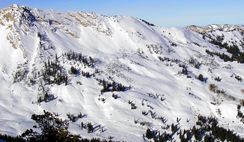
Tue Jan 19, 2010 6:28 amby TyeDyeTwins
Close but no cigar.....The run pictured above is of Cardiac Ridge. High Ivory is further down the Fork. The picutre below is of (from left to right) Ivory Tower, Ivory Flakes, Tyrons, and finally High Ivory.
Posted:
Tue Jan 19, 2010 9:10 pmby seanpeckham
Ah, thanks. Sorry to clutter the thread with posts about where everyone else had apparently already travelled first.
Posted:
Wed Jan 20, 2010 5:49 amby TyeDyeTwins
Went to Reynolds Peak today to check out how the storm affected the snowpack stabilty. We found some wind drifting on the northerly slopes as well as some new cornices. From the top of Reynolds Peak we got a look at some of steeper lines of the Wasatch. The only activity (more like concern) we saw was a large glide crack that has opened up on Broads Fork's Bonkers. We skied the main east bowl with not so much as a sluff. I'd call it a pockety moderate day for wind slabs with an extream danger of having an epic blue bird powder day. Neils (pictured) can attest to that.

Posted:
Thu Jan 21, 2010 9:07 pmby Ed F
Broke trail in and lapped USA Bowl this morning. It was blower for most of the tour with a small window of visibility here and there. Windy near the ridge tops. Probably an average of 18"-24" of new snow throughout, with another 2-3" while we were touring. New snow seems to bond well to the old stuff, but bonding is the least of our worries out there right now. I didn't see the moisture density of the new snow, but it felt a bit heavier than the standard Wasatch mid-winter storm. Best day I've had this year by far...finally found the white room after about a month of looking...
Keep it coming, Mother Nature. Hoping for a nice fill-in between now and the end of the storm.
Posted:
Fri Jan 22, 2010 4:40 amby marauders
Ah, I'm jealous. I'm desk-bound all week. Nice pic Sean.
Posted:
Sun Jan 24, 2010 8:11 pmby Ed F
USA Bowl again. Broke trail again (ouch). Got up early to avoid the road closure and had the joint to ourselves for a bit.
Dug a pit near the top of the skiable terrain in USA and got a column to fail on the second wrist tap. The column broke well below the new snow and into the old stuff, pretty much confirming the avy report today. Couldn't see anything else--snowed the whole tour.
The turns out there are just epic right now. This storm finished really dry.
avalanche field class
Posted:
Mon Jan 25, 2010 5:21 pmby climbingchic
I haven't had the chance to skim through this thread, so I don't know if this has been talked about, but I'm interested in taking a field class on checking the snow for avalanche danger. I go to REI's class every year for a review on what to look for regarding conditions, the weather and such but want firsthand to check out the snow. Does anyone of a field class taught, preferrably for no more than around $100?
Re: avalanche field class
Posted:
Mon Jan 25, 2010 5:49 pmby Ed F
climbingchic wrote:I haven't had the chance to skim through this thread, so I don't know if this has been talked about, but I'm interested in taking a field class on checking the snow for avalanche danger. I go to REI's class every year for a review on what to look for regarding conditions, the weather and such but want firsthand to check out the snow. Does anyone of a field class taught, preferrably for no more than around $100?
You're talking about AIARE Avalanche I. It's usually a full weekend: Friday night class, then Saturday and Sunday in the field. The
UAC is a great place to start looking for a class. There are links on the home page. I doubt you'll find a class for less than $100.