Page 1 of 1

Signal Peak (UT)

PostPosted: Tue Jan 12, 2010 4:34 pm
by JDrake
I'll be in the St. George, UT area this weekend looking to visit Signal Peak. I understand the Pine Valley approach is preferable during winter and that avalanche danger is minimal. Any info or advice regarding winter route/conditions would be appreciated. Possible to hit Burger Peak along the way? I hear there is some bristlecone pine in the area... :)

PostPosted: Tue Jan 12, 2010 5:47 pm
by MoapaPk
Don't know about the Pine Valley side; someone else can chime in there. The Dixie Nat'l Forest folks are sometimes helpful:
http://www.fs.fed.us/r4/dixie/index.shtml

I'm guessing that the Oak campground on the SE side (road out of Leeds) is probably navigable. That trail is south-facing, and I don't recall seeing anything that looked like an avalanche chute right there. The trick comes when you drop down to Deer Flat and Further Water; that area often has snow up through June.

The top plateau of the mountain is wooded; the highpoint has a viewpoint about 100 feet to the south, and is hard to discern unless you have the waypoint on a GPS. The range has lots of lumpy summits that are like rolling, wooded hills perched on a cliff.

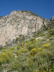
The southern route is like this much of the way:
Image
for some reason SP is acting retarded with links right now, so go to:
http://hwstock.org/sig/

When you are in St George area, look and see the snow coverage on the south side of the peak. There are probably web cams that point to the mountain.

If someone has already traveled the Pine Valley trails (I'm guessing you want the "Summit Trail"), they may be packed. Otherwise those trails will be hard to find in the snow.

PostPosted: Wed Jan 13, 2010 6:34 pm
by JDrake
MoapaPk wrote:Don't know about the Pine Valley side; someone else can chime in there. The Dixie Nat'l Forest folks are sometimes helpful:
http://www.fs.fed.us/r4/dixie/index.shtml

I'm guessing that the Oak campground on the SE side (road out of Leeds) is probably navigable. That trail is south-facing, and I don't recall seeing anything that looked like an avalanche chute right there. The trick comes when you drop down to Deer Flat and Further Water; that area often has snow up through June.

The top plateau of the mountain is wooded; the highpoint has a viewpoint about 100 feet to the south, and is hard to discern unless you have the waypoint on a GPS. The range has lots of lumpy summits that are like rolling, wooded hills perched on a cliff.

If someone has already traveled the Pine Valley trails (I'm guessing you want the "Summit Trail"), they may be packed. Otherwise those trails will be hard to find in the snow.


Thanks for the info and the links MoapaPk. You're right: Dan at the PV ranger station was pretty helpful. The road to the Oak Campground trailhead is closed so we'll be approaching from PV using the Forsythe trail area. Snow midweek with good weather Sat and Sun. Should be a long, enjoyable snowshoe! We'll waypoint the summit...

By the way, thanks for helping me "figure things out on my own" (to borrow a thread title). :wink:

PostPosted: Tue Jan 19, 2010 5:00 pm
by KirtDavis
I went to the peak a few years ago the end of May. The route up from Oaks is steep and long. When we crossed the ridge, we were postholing in knee deep snow, regretting leaving the snowshoes back at camp.

Its is a great hike, enjoy!