Page 1 of 1
Island peak ascent advice

Posted:
Wed Aug 31, 2011 4:26 pmby justahiker
Hello everybody!
I intend to join a commercial expedition which will climb Island peak (6,183m) in April next year.
This is my first experience on this high altitudes and generally in Himalayas. So, any kind of advice is more than welcome, especially from people who climbed the summit or those who climbed in the region.
Thanks!
Re: Island peak ascent advice
Posted:
Wed Aug 31, 2011 6:56 pmby Rafa Bartolome
You must follow the stages of trekking, it's the most important thing. Don't run to make two stages in the same day. The body needs time. A good option if you have time is make trek of Gokyo with the climb of Gokyo Ri (5,300m) passing across Cho La to climb Kala Pattar (5,600m) descending across Everest BC trek. When you reach Island base camp (4,970m) you have very good conditions to start the climb of Island peak because you have two peaks of more than 5,000m in your legs and you have slept at least two nights around 5,000m (a night in the very cold Gorak shep at 5,140m is advisable). If you don't have 2 weeks you can make the shorter route reaching Kala Pattar across Everest BC returning from it to enter to the valley of Island Peak after a night in Gorak Shep. It's most popular the night at Lobuche (4,910m) because it's not so cold as Gorak Shep but for the acclimatization it's a better place because is 200 m high. The rest of the stages are very similar in the companies: lukla-phakdking, namche bazaar, acclimatization day visiting Hotel everest view or khumnjung (a lot of people return to Namche Bazaar but it's also a good option to slept in the less overcrowded Khumnjung). After that you don't need to repeat the place to sleep. The next stage is the point to choose the two trekking, Gokyo or Everest BC.
Re: Island peak ascent advice
Posted:
Wed Aug 31, 2011 8:23 pmby justahiker
Thanks Rafa!
Originally whole 3 weeks are planned for this trip, so I believe stages are well planned. Thanks for all your info.
Re: Island peak ascent advice
Posted:
Thu Sep 01, 2011 7:57 amby Bruno
if your plan is to go in April, I would recommend you to go as early as you can in that month, so you will enjoy less crowd. This year there were 11 people on the top on 10 April, around 15-20 on 11 April, and just 5 on 12 April. I heard it can be much more crowded later on, which can be quite unpleasant in the fixed rope section.
Apparently the route has slightly changed over the past years, with the attack of the summit wall being now more to the right, closer to the summit. On the other side, the summit ridge was just an easy walk this year, with nothing technical.
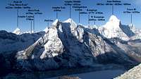
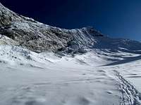
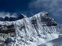
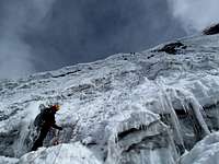
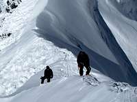
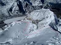
The route on the glacier starts at 5830m and is short (360m elevation gain) but nice, with 4 different sections:
1) A short zigzag between seracs at the beginning of the glacier
2) A plateau on gentle slope
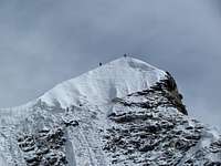
3) A steep but straightforward climb of the headwall
4) A very short broad ridge up to the summit
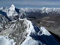
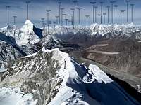
The views during the climb and at the summit are truly breathtaking!
Depending on how you like to travel/climb, Imja Tse can easily be done on your own without joining a commercial trip, even for your first time in the Himalaya. There are guesthouses everywhere on the trail up to Chhukung, and you can't miss the climbing route, which is quite obvious and easy (but be aware that conditions may change rapidly). Beside alpine climbing experience, some previous jumaring/rappelling experience is however needed if you go alone. Otherwise it is a nice peak where to get first experience at it.
Re: Island peak ascent advice
Posted:
Fri Sep 30, 2011 1:36 amby minus800
Some good advice has already been posted, but here's my penny's worth: If you've already selected your commercial company then your dates, route and schedule are already pretty much set. That said, I will disagree with Bruno over the timing, the beginning of April is a very busy time for trekking. There are often a lot of people sleeping in the dining rooms of lodges because they're all full. May, to my continued surprise, is quieter with fewer people on the trails.
If you want to tell me who you're going with I could probably give you a bit more specific advice, you can contact me privately if you don't want it out there. I'm a guide and know most of the companies. But it is really important to listen to your body and your company should have built plenty of rest days into the schedule, so that you can stay an extra night somewhere if you get sick. Be prepared to get an upset tummy, it happens to just about everybody. Its usually not a big deal, but have Immodium along.
Rafa's route through Gokyo and EBC is a great idea, but again your route has already been planned. But the main point is that by the time you get to Island Peak BC you will already have all the acclimatization you will need for a quick, successful ascent.
Re: Island peak ascent advice
Posted:
Wed Oct 19, 2011 9:39 pmby mosh
Hi, I will be doing Lukla-Gokyo-Cho La- Kala Patar-Chukhung- Imja Tse starting 9th of November. It is my first trip to Nepal.
I read in Jamie McGuinness's book that the Island Peak route can be tricky to find sometime. Here I read in one comment that the route is very straight forward.... who to believe?...
Also, I hire a climbing sherpa with plenty of experience,is it possible to request front pointing on the headwall instead of jumar/fixed lines? I have Scottish II experience and would prefer to front point rather than 'join the queue' for the fixed rope.
Thanks for your answers
Moshe
Re: Island peak ascent advice
Posted:
Thu Oct 20, 2011 1:58 amby radson
Moshe, yes you can make your own way up the face rather than jump on the fixed lines. Basically you can do what you want with respect to other people on the mountain.
Re: Island peak ascent advice
Posted:
Thu Oct 20, 2011 8:54 amby Bruno
Hi Moshe,
As Radson said, both options are OK.
Route finding is really no problem at all. First the route is very intuitive, second you will most probably be with several other climbers at that time of the year. Here some GPS waypoints I took between Chukhung and the summit (but I doubt you will need them):
27°54'17.18"N 86°52'18.88"E Chukkhung - 4757m
27°54'9.91"N 86°55'52.37"E Imja Tse BC - 5102m
27°54'11.49"N 86°56'9.75"E End of BC start of route 5144m
27°54'36.88"N 86°56'3.92"E High Camp 5538m (other HC possible 100m lower)
27°54'52.56"N 86°56'1.52"E Start of glacier 5837m
27°55'9.44"N 86°56'3.13"E Bottom of the Wall - 6044m
27°55'10.83"N 86°56'3.12"E Summit ridge - approx. 6150m
27°55'12.11"N 86°56'4.67"E Imja Tse Summit - GPS 6184m
I also attached you some recent pictures from last April. Post monsoon conditions may however by quite different. Enjoy your trip!
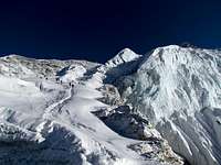
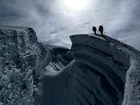
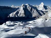
Check
here for the description.
Re: Island peak ascent advice
Posted:
Thu Oct 20, 2011 7:22 pmby radson
Great pics Bruno