Wasatch Avalanche Conditions

Regional discussion and conditions reports for the great state of Utah, from the alpine peaks to the desert slots. Please post partners requests and trip plans here or in the Utah Climbing Partners section.
User Avatar
TyeDyeTwins

 
Posts: 208
Joined: Thu Apr 09, 2009 2:40 am
Thanked: 24 times in 17 posts

by TyeDyeTwins » Thu Mar 18, 2010 4:25 am

Observation March 17 Went up to Red Pine Fork today to ski the Little Pfeifferhorn. Due to the warm temps we were only able to pull off one lap of smooth powder skiing on the Northeast bowl. Skied all the way to the lake without incident. We saw lots of natural wet avalanche activity out there, most of which was on west facing aspects. All slides observed today were in the form of point release avalanches. Most of upper Red Pine Fork was wind damaged but good skiing was still easily found. For the most part the avalanche danger (excluding warming) was pretty low today. Still, thats no excuse to break the rules of the Backcountry (see pic #2).
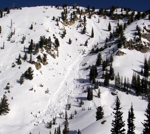
The 1st picture is of me standing next to the largest point release avalanche we observed in Red Pine Fork. This was on a west facing aspect and was over 5 feet deep in the deposite zone.
Image
The 2nd picture is a great exsample of what NOT to do in the backcountry. We observed this group of 2 break one of the major rules of BC skiing. Remember that regardless of the avalanche danger there should never be more than one person on the slope at one time.
Image
The 3rd picture is of the extesive wind damage on White Baldy
Image

no avatar
marauders

 
Posts: 652
Joined: Wed Dec 08, 2004 1:25 am
Thanked: 13 times in 7 posts

by marauders » Thu Mar 18, 2010 6:56 am

On Saturday I was in the Cardiff Fork area. North and northeast skied well. Stable, light and smooth. South was cooked through and through. It was tough, unpredictable down to the car in LCC. There was a lot of wind damage on almost everything outside of the protection of trees. Appears to be corn season on the horizon.

Any input on time of day to hit the various aspects for good corn?

User Avatar
Ed F

 
Posts: 993
Joined: Sat Sep 07, 2002 8:15 pm
Thanked: 17 times in 14 posts

by Ed F » Thu Mar 18, 2010 12:48 pm

marauders wrote:Any input on time of day to hit the various aspects for good corn?


Are you talking in general? In general, I use this rule of thumb: 9am East, 11am South, 1pm West, North always depends. However, we're going to need a solid freeze-melt cycle to get things firmed up. Check out the temps on Cardiff: http://www.wrh.noaa.gov/mesowest/getobe ... f&hourly=1. They've barely been below thirty for the past few days at night, with significant daytime warming.

I still think we've got some winter left. Remember last year when we got 150" from late March to early April? I'm not retiring my powder sticks just yet...

Oh, and since it snows every time I leave town, wax up your boards for Sun-Tues because I've got a desert trip planned.

User Avatar
TyeDyeTwins

 
Posts: 208
Joined: Thu Apr 09, 2009 2:40 am
Thanked: 24 times in 17 posts

by TyeDyeTwins » Sun Mar 21, 2010 3:43 am

Observation March 20 Went up to Red Pine Fork today. From the Red Pine Fork overlook area we got a good veiw of the Coalpit Gulch avalanche that was triggered yesterday. This avalanche in Coalpit Gulch was the result of burried Depth Hoar and was 4 feet deep at the crown. The only avalanche activity we found in Red Pine Fork was a blown in avalanche crown low down on the Upper Red Pine Cirque. Winds and possibly grauple played a factor in this avalanche. All areas where grauple is known to pool were thusly avoided. Smooth powder can still be found out there. Just keep your plans high and northerly.
The 1st picture is of the avalanche in Coalpit Gulch
Image
The 2nd picture is of Troy taking a late afternoon ski run into Red Pine Lake
Image
Last edited by TyeDyeTwins on Tue Mar 23, 2010 3:04 am, edited 1 time in total.

User Avatar
TyeDyeTwins

 
Posts: 208
Joined: Thu Apr 09, 2009 2:40 am
Thanked: 24 times in 17 posts

by TyeDyeTwins » Tue Mar 23, 2010 3:56 am

Observation March 21 Went up to Mount Wolverine and Patsy Marley the other day. Skied the stupid chute, Grizzly Gulch's Queen and then skied a home run down the west face of Patsy Marley. Only saw one avalanche all day. It was a point release avalanche in Grizzly Gulch's Grizzly Cup, a steep south facing gully. This was one of the larger avalanches that this run has seen this year with debries coming within feet of the summer trail.
The 1st picture is of the avalanche in Grizzly Cup
Image

User Avatar
TyeDyeTwins

 
Posts: 208
Joined: Thu Apr 09, 2009 2:40 am
Thanked: 24 times in 17 posts

by TyeDyeTwins » Fri Mar 26, 2010 3:26 am

Observation March 24 Used Grizzly Gulch to get to Silver Fork. Skied one lap near the East Bowl pass and two more at North Davenport. New snow was about 4 inches total but crust was felt underneath my skies just about everywhere but high northerly elevations. Avalanche activity was non-existant despite the warm temps during my exit.
The 1st picture is of a new posted sign at the site of this years avalanche fatality in Silver Fork's Meadow Chutes.
Image

User Avatar
TyeDyeTwins

 
Posts: 208
Joined: Thu Apr 09, 2009 2:40 am
Thanked: 24 times in 17 posts

by TyeDyeTwins » Sat Mar 27, 2010 3:45 am

Observation March 26 Went up Mill D North via Short Swing and out Beartrap Fork today. Heavy snowfall provided some good powder, but the old crust could still be felt with every turn. Grauple fell off and on all day. First tour of the year where I was more concerned about being struck by lightining than getting caught in an avalanche.

User Avatar
TyeDyeTwins

 
Posts: 208
Joined: Thu Apr 09, 2009 2:40 am
Thanked: 24 times in 17 posts

by TyeDyeTwins » Sun Mar 28, 2010 2:55 am

Observation March 27 Went up Butler Fork today to ski Circle Awl Peak. Skied a couple of laps in the Northeast trees. Started a small sluff on our last lap. The sluff was only a few inches deep and did not involve all the new snow.....only about half (must have been a desity inversion layer). The snow was otherwise non-reactive although we left before the big warm up in the afternoon. The spring powder days are here.
The 1st picture is of Troy skiing Circle Awl Peak today.
Image

no avatar
marauders

 
Posts: 652
Joined: Wed Dec 08, 2004 1:25 am
Thanked: 13 times in 7 posts

by marauders » Mon Mar 29, 2010 5:18 am

Saturday, March 27th Superb day on Roberts Horn. Skied E and N aspects. Soft, creamy powder by 1pm on E. Nice dry powder pockets on N. No current instabilities, but we did see lots of wet sluffs from the pre-storm heat wave. Glorious day out in the mountains.

Image
Image
Image
Image
Image
Image
Image

no avatar
Dan Shorb

 
Posts: 583
Joined: Thu Apr 08, 2004 2:06 pm
Thanked: 41 times in 29 posts

by Dan Shorb » Mon Mar 29, 2010 5:21 pm

marauders wrote:Saturday, March 27th Superb day on Roberts Horn. Skied E and N aspects. Soft, creamy powder by 1pm on E. Nice dry powder pockets on N. No current instabilities, but we did see lots of wet sluffs from the pre-storm heat wave. Glorious day out in the mountains.

Image


Damn I'm jealous. that's awesome!!

User Avatar
TyeDyeTwins

 
Posts: 208
Joined: Thu Apr 09, 2009 2:40 am
Thanked: 24 times in 17 posts

by TyeDyeTwins » Tue Mar 30, 2010 4:33 am

Observation March 29 Went up to Wolverine Cirque the other day and skied the Granny Couloir to Figure 8 Hill. Skinned back up to Twin Lakes Pass and out to Silver Fork. Got several laps on North Davenport and finished the day with a lap down Flannigans. We triggered a minor sluff in Silver Fork but otherwise things were pretty stable out there. We saw wet avalanche activity in The Huge Chute and The Meadow Chutes. Both avalanches were wet point releases and both slopes were east facing.
The 1st picture is of the avalanche in Wolverine Cirque
Image
The 2nd picture is of the wet avalanche in The Meadow Chutes.
Image

User Avatar
Ed F

 
Posts: 993
Joined: Sat Sep 07, 2002 8:15 pm
Thanked: 17 times in 14 posts

by Ed F » Sat Apr 03, 2010 12:22 am

Great day to be alive today. Skied Toledo Bowl (southeast-facing on south of Flagstaff) first, and it was a bit more moist and wind-loaded than I would have liked, but still a good ski. Then we hit Holy Toledo (southwest facing on west side of Flagstaff), which was nothing short of spectacular. We went up the center ridge of Cardiff, and out on Southeast Cardiff Peak, which by 1pm was pretty wet and tough to ski. New snow was anywhere from 24" to well over 30".

Things were pretty solid today on all aspects. Once the sun came out, wet slide danger went up, but that's always pretty obvious and avoidable. There were also some low clouds that caused some greenhousing, which ruined some snow a lot quicker than normal for the relatively low temps (15-25). The sluff danger with the new snow was really manageable, and people were skiing lots of stuff today. I did see this small slide of the new snow in Holy Toledo's center shot, but it only incorporated the top of the new snow and I doubt the skier got knocked over:

Image


Looks like winter decided to wait for April this year.

User Avatar
TyeDyeTwins

 
Posts: 208
Joined: Thu Apr 09, 2009 2:40 am
Thanked: 24 times in 17 posts

by TyeDyeTwins » Sat Apr 03, 2010 6:09 am

Observation April 2 The 2 of us split up and went our different ways today. Troy went to Little Water Peak and skied several laps of blower powder on the Millcreek side. By the afternoon the snow on the north facing Millcreek Ridgeline was starting to get wet. No activity was encountered.


I went up to Peak 10,420 this afternoon. At the summit the winds were transporting lots of snow into the Northeast Trees well off of the ridgeline all the way to the steep roll overs. Beacause of this a more conservative line into the Northeast Trees was taken and skied without incident. By the time I returned to the summit for my second lap down the Northwest Trees the winds increased significantly into the 30-40mph catagory. Still blower powder in the Northwest Trees was found at 5pm. Weather focasters are sayin that we are gonna get another 8-16 inches tonight.......might just have to get up early tomorrow.

User Avatar
Ed F

 
Posts: 993
Joined: Sat Sep 07, 2002 8:15 pm
Thanked: 17 times in 14 posts

by Ed F » Mon Apr 05, 2010 1:23 am

Old business first. A photo of the Days Headwall avy from yesterday (which got my attention in a big way):

Image

We skied the Powder Purse (North and Northwest trees in east Willow Fork) first today. It was at least 14-16" deep in most spots with no instabilities. Then, we skinned through the center of Willow Fork to Monitor Peak to take a look at the Monitors. We noticed another small slide in the Powder Purse off the ridge separating Willow Fork from USA Bowl (Mill F). This slid earlier this year, and I'm pretty sure wind transport created a shallow, nasty snowpack here. I'm pretty sure it ran naturally:

Image

North Monitor slid big today. I wasn't there when it went so this is all speculation, and I'm sure someone will report it to the UAC, but I'm pretty sure someone did a cornice drop (or maybe two) that brought the house down. This area all faces due east. There were two slabs that pulled out: one ran on the "west Desert" layer of dust; the other ran below that layer. I never got close enough to even take a guess how deep it was. Some party of skiers hit it today without incident, most likely before it slid given where their tracks were. We both could have sworn we saw tracks in the bed of the slide, but it was really hard to tell with very flat light all day today. Anyway, we took a conservative line down that faced more north and with less angle, and I could really feel the instabilities in the snowpack as we skied the lower-angle terrain. I did a really solid ski cut on the one rollover on our run and was very pleased with the results (I'm pretty sure it was all a matter of angle and not "safer"). Several parties followed us down with no problems. The snow was fantastic. There was also quite a bit of wet snow slides adjacent to the slab(s) that pulled, as you can see below.

Photos:

Image

Image

Image

I'm pretty sure this slide was a result of the weather today. It was sunnier in the morning when the solar radiation was cooking that east-facing slope, but the sun went away pretty quickly and we had nice, overcast skies all day that kept the snow pretty nice. You could have probably skied a nice run on some south-facing stuff as late as 11am today. The skies stayed overcast all day until the new front moved in at about 3pm. Most of the snow survived today relatively unharmed.

We exited Will's Hill on some more over-the-head powder. No instabilities noted here at all, and the snow was still light density blower at 4pm. Some of the best snow I've had all year. More snow on the way...

Edit: I forgot that McDonalds Draw also slid out almost completely from a bomb from the Canyons ski resort. We were going to ski a small shot I think is called McD's that faces more north, but it had been wind-loaded in a really funky way, so we passed.

User Avatar
TyeDyeTwins

 
Posts: 208
Joined: Thu Apr 09, 2009 2:40 am
Thanked: 24 times in 17 posts

by TyeDyeTwins » Tue Apr 06, 2010 3:38 am

Observation April 4 Went up to Peak 10,420 on Sunday. At Guardsmans Pass lots of shallow pockety sluffs and cracking was found on nearly every roll over on the East, North and West facing slopes over 35 degrees. Because of the shallow nature of this instability we were able to ski the steep Northeast Trees without any incident. We summited the peak again and skied into the Northwest Trees. When we reached the steep section (40 degrees) Troy was able to start a shallow (only a few inches deep) soft slab with a hard turn. The slide (more like large sluff) only ran 50 feet or so and was not all that concerning. Overall it sounds like the avalanche danger was more concerning elsewhere in the Wasatch (see Ed F's observation above). With a 3-5 feet of new snow on the ground and another couple more feet on the way tonight/tomorrow, things are finally starting to look like the winter we all remember, know, love and ski for in the Wasatch.
The 1st picture is of the shallow slide Troy triggered in the NW Trees of Peak 10,420
Image
The 2nd picture is of Troy making the hard turn that started this small avalanche.
Image

PreviousNext

Return to Utah


  • Related topics
    Replies
    Views
    Last post

Who is online

Users browsing this forum: No registered users and 0 guests