
|
|
Mountain/Rock |
|---|---|
|
|
33.0121°S / 69.4466°W |
|
|
Mountaineering |
|
|
19117 ft / 5827 m |
|
|
Overview
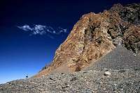
Pico Plata is the second highest point in Cordon del Plata. Some maps and the guide book for the area states it’s 6100m, but a GPS reading will tell you different. A more plausible elevation of the peak is 5843 which is the adjusted average of the readings I got. Pico Plata's bigger sister Cerro Plata is nearby and about a hundred meters higher. As most climbers are interested in climbing as high as possible, they head straight for Plata and give Pico Plata a miss.Both peaks are walk-ups, but Pico Plata has no well-travelled foot-paths as the more popular peak have. What talks in Pico Plata’s favour is the excellent views of the lower valleys to the south and the long walk on a scenic ridge to its summit. There are many false summits on the way, but when you have clear views of Cerro Plata’s triangle-shaped snow cone and it starts to drop dramatically steep, you can be sure you have reached the summit.
Many people call the peak Platita, which means "the little Plata". Some call it Pico Plata, which tranlates to something like "Point Plata".
Far to the south in Cordon del Plata there's another peak also called Platita, not to be confused with the peak this page is about.
Getting There
 Looking down the east face on a cloudy day
Mendoza is the main city in the area and there are plenty of companies which offer you a tour or expedition to Cordon del Plata. Some only to the vantage points around the ski station, some all the way to the summits of the highest peaks in the area. The tour companies, the climbing shops or even most youth hostels can help you arrange a journey to Cordon del Plata. If you want to arrange it all by yourself, the easiest and cheapest way is to take a normal bus to the little settlement Potrerillos which is an hour away from Mendoza. This is a town where the last minute provisions can be bought. It’s fairly easy to hitchhike to Vallecitos Ski Centre, which is at 2980m and 28 steep km from Potrerillos. There are several settlements before the ski centre, most of them only a few houses. There is an excellent restaurant and hostel 6km before hitting the ski station and it’s a very popular stop for starved climbers on the way down from the mountain adventures. You can leave excess gear in the ski station for a small fee. There is a shop where you can buy some gear and clothing and a little restaurant is the last house you pass when you start your walk towards the mountains.
Cross the river on your left and follow the foot-paths until you arrive at some wide, green fields, crossed by small rivers. This is Las Vegas camp and it’s a good place for the first night’s camp in the area. If you feel like going further, continue in the main (left) valley with a rock-wall peak in the end. The Peak is Vallecitos. Follow the path up some steep grassy slopes along the river. When you’re at roughly 3500m at a huge rock and can see the grass and the greenery is about to finish you’re at Piedras Grandes, a good camp spot. There is not so much water further on, so you better fill up here before heading for Camp Salto, which is a couple of hours walk from here. On your left you see Cerro Franke and on the right hand side there’s a colourful wall leading all the way to Cerro Rincon. The last part of the walk to Camp Salto is quite steep on loose scree.
In the climbing season you can buy provisions, snacks and even eat pizza and drink beer! Tents to the right in the valley, toilets on the left hand side of the river. Walk over the little ridge if you don’t want to be seen when doing your business. The water is safe to drink if you fill up your bottles very close to the pipe at the rocks. Further down it may be contaminated or at least not so nice to drink as people brush their teeth etc.
If you don’t like to camp where there are too crowded; walk on for another five minutes and camp on top of Camp Salto. Good platforms and shelters. Some water close by.
Most people attack Pico Plata from here, even though I would say it’s better to walk further up the valley to the next camping place; Camp Hollada at 4300m. From this place you have excellent views of the rocky faces of Vallecitos and Rincon and also the forepeaks of Pico Plata are visible. You’ll get water from either melting some snow, or walk down into the valley for 200-300m where you’ll find a melt-off river with clear water.

The map shows you the relevant parts of Mendoza Province. Blue boxes for the most important places. Pico Plata is located very close to C del Plata. Cordon del Plata is on the way to the Aconcagua Massif and therefore perfect for acclimatization. In the lower left hand corner, the cover of the map is shown. The best road map for the area.
Red Tape
No peak fee. You have to register in the ski station. Go to the little shop where you buy gear. It’s easy recognized by a sign saying “Makalu” (a local gear brand) and is located a hundred meters from the parking lot. The second option to register is in the little restaurant, which is on top of the main yellow buildings. Walk around the latter, double back and walk up the stairs to the next level of houses. The restaurant is recognized by the big dog house, complete with a Saint Bernard dog outside. The authorities want you to inform them about your intended length of stay and the objectives you have in mind.When To Climb
 Views from the summit, clouds far below
The peaks in Cordon del Plata are climbed in all seasons. In the warmer months/the summer months of the southern hemisphere you climb on rocks in warm surroundings. The camps are on green meadows and higher up, in Camp Salto you even have a little restaurant tent at 4200m. In the winter, the area is full of nice snow and ice climbs, but the conditions are of course much rougher. In the snowy season it can sometimes be difficult to reach the peaks, but the road is usually cleared in a day or two.
If not going for the standard or the ridge route, there are some more challening alternatives. The huge, steep face in the south is supposed to be a nice winter climb.
Camping
Camping is allowed everywhere in the area. In Camp Salto you sometimes have to ask where to pitch the tent when the camp-area is crowded. No huts.Accommodation is to be found in Vallecitos ski resort. It’s a basic guest house with small restaurant and mini-shop connected to it.
Mountain Conditions
 Strong colored rock face on the route
The weather sites for Mendoza is an ok source of information to get the general idea about what you can expect the next couple of days, but Cordon del Plata is plagued with local and fast changing weather patterns. The people living in the ski station are by far the best source for fresh broadcasts and their knowledge about the weather patterns is extensive. When walking to Camp Salto, the guides and the caretaker who lives there are the persons to ask.
Books
The only book about the area is; “Mountains of light/Cord of the Silver” written by Alejandro Geras. It gives you all the information about the area and there are also sections about Aconcagua, high altitude medicine, nutrition and other alpinism-related topics. The maps and route-descriptions are good and there are plenty of photos of peaks which help you out a lot locating specific mountains without any prior local knowledge. There is one problem though; the translation. If you know Spanish, this version is for sure a better choice. The English version is sometimes ok and easy enough to understand, but some sections I didn’t understand at all. The below section is not to make fun of the author’s translation, just to let you know what I mean with bad translation. Then you can judge if the book is worth buying or not. This is one of the worst parts.From the gear list:
• Stock market of Vivac: A covers stock market it improves the heat insulation of stock-market to sleep and improves the conditions of a vivac.
A shop that sells the book is El Refugio. See below.

Budget accomodation in Mendoza
If you're on a tight budget or want basic accomodation in Mendoza, Hostel Independencia is a good alternative. It's conveniently located at the main park in the center of the city. The permit office for Aconcagua is a five minute walk away and so are the gear shops, restaurants etc.The hostel is also a good source of info and there's a mountaineering agency operating in the hostel's premises.
This company can also provide rides to Cordon del Plata, clean white gas and other useful things and services for a mountaineer.
In early 2006 the price for a dorm was 20 Argentinian Pesos and a double went for 50.
1USD = 2,94ARP
Shops and outfitters in Medoza
There's one really good mountaineering shop in Mendoza.Orviz is located on Juan B Justo, a little bit away from the main center.
See map.
The shop has all you can possibly need for any type of mountaineering.
Lots of gear for rent and sale.
Highly recommended.
There are a few more shops on Sarmiento, Las Heras and Suipacha in central Mendoza.
glenns - Dec 2, 2009 2:48 pm - Hasn't voted
Cerro Platita is not Pico PlataPico Plata is just below Cerro Plata as described. Though Cerro Platita is a different 4216 meter peak farther to the south. Platita is the southern most high peak of the Cordon del Plata. It is located at 69° 24' 6.3"W, 33° 4' 5.91"S. The rest of the entry should be correct just remove any reference to Platita.
Corax - Dec 2, 2009 7:02 pm - Hasn't voted
Re: Cerro Platita is not Pico PlataYes, there's a lot of confusion about the peaks in Cordon del Plata. I know about the other Platita you mention. In the material I have the peak in question is mentioned as Pico El Plata, Pico Plata and Platita, so I guess all these names creates confusion. I will remove the word Platita to make it simpler. Same goes for Pico Vallecitos and Cerro Vallecitos. The former is just a high point on the ridge, which a huge majority of the climbers reach and claim the that they have climbed Vallecitos. In reality they have only reached a fore peak or high point. I also have a map where the Adolfo Calle and Stepanek are mixed up.
glenns - Dec 3, 2009 1:21 pm - Hasn't voted
Re: Cerro Platita is not Pico PlataYes your entry is useful for the Plata approach, but I had been confused while investigating the Cerro Platita which I was looking to hike. My map shows Pico Plata just below Plata, which I believe is your entry. The map is "Cordon del Plata" from Meridies-Aoneker GIS Solutions 1:50000. Though it seems the company has split it's name and is now has just publishing maps as Aoneker with a Cordón del Plata map at 1:40000 http://picasaweb.google.com/Aoneker/MapasPublicados#5267507596558674082 I cannot read how they have that peak listed from their image on posted on the web.
Corax - Dec 4, 2009 1:31 am - Hasn't voted
Re: Cerro Platita is not Pico PlataThe Meridies map has given the two peaks separate names. Pico Plata and Cerro Platita. I enlarged the map on the URL you pointed to and it's given the same way there, and it should be as it appears to be a copy of the original Meridies map. I have changed some on the page about Pico Plata and also on the Cordon del Plata page, so no confusion is created. I have mentioned that Pico Plata sometimes is called Platita though. The first time I was in Cordon del Plata, Platita was the name given to me by some people in Camp Salto. Please comment if you think I should change or clarify anything, as it's no good if the information is unclear and climbers are mixing up the peaks.
glenns - Dec 4, 2009 5:42 pm - Hasn't voted
Re: Cerro Platita is not Pico PlataYes I can see how the name of Pico Plata might also be Platita in Spanish. Your changes mentioning the possible name confusion will certainly make it clear. Thanks.