
-
 19516 Hits
-
 79.78% Score
-
 11 Votes
|
|
Mountain/Rock |
|---|---|
|
|
37.37530°N / 118.7726°W |
|
|
13268 ft / 4044 m |
|
|
Overview
Sandwiched between Bear Creek Spire and Mt. Dade, Pipsqueak Spire is the least known one of the trio that dominate the western skyline when you reach the Long Lake and beyond. It however sports a beautiful east face and connected to Mt. Dade via a series of spires that would only be clearly visible when you climb up the famous hourglass couloir. The easiest way to climb Pipsqueak is to ascend the Hourglass Couloir and then climb up the class2/3 north slope. Many people climb it when traversing between Bear Creek Spire and Mt. Dade. | 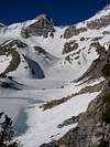 | 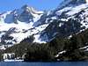 |  |  |
Getting There
Southbound on highway 395, 20+ miles after passing Mammoth Lakes, turn off at Tom's Place. Additional nine miles of driving brings you to the highest trailhead in East Sierra, Mosquito Flat, at 10200 feet. From the trailhead to the Long lake is a 2-mile scenic hike along the trough of the Little Lakes Valley that bring you pass four beautiful lakes, with little elevation gain or loss. From Long Lake, hike along its right shore to reach the opposite side of the lake. From here you can either ascend the glacier-carved valley until you reach Teasure Lakes, or stay a little bit high on the right side of the canyon, hiking up two short, gentle slope. The route many take is to stay high on the right until you reach the two small lakes of the Teasure lakes, hike around them and ascend another slope to reach the bottom of the Hourglass Couloir surrounded by a nice cirque. Slag up the 40-degree couloir to reach the saddle between Mt. Dade and Pipsqueak. Here you will find a hidden lake resides in a high cirque formed by Mt. Dade, Pipsqueak, and the connecting spires and ridges. From here, climb up the class2/3 north slope. A more aesthetic way to do it is to veer off to the left when you reach the upper 1/3 of the Hourglass couloir and climb along the edge of the sheer east wall of Pipsqueak and then ascend along the east ridge of the Pipsqueak.Red Tape
Little Lakes Valley is a very popular dayhike/backpacking starting point. Weekend permits are difficult to obtain during summer months, once the road is open to the trailhead. All three peaks mentioned above can be done as a reasonabe dayhike though.When To Climb
In spring, when the high lakes are frozen and the slope well-covered by snow, this is a fine ski mountaineering area. You can descend 3000+ feet to the lower lakes. Summer months bring typical rock scrambling to the ascend. To do it in winter, several miles of hiking up may be required.Camping
Many camping site along the road up the Rock Creek Valley ($16); Mosquito Plat has some camping spaces that is limited to one-night usage. Bear boxes are provided at the trailhead. As suggested by the name of the trailhead, be prepared for the little creature in summer. Some camps low along the road to get out of the mosquito-fested area; acclimatization also is one factor to consider when choosing a camping site.The Rock Creek Lake Resort provides services for token-operated hot-water shower, grocery, fishing equipment rental, and delicious chili, burger, and yes, Sue's famous pies.
Mountain Conditions
Check Rock Creek Lake Resort's website for winter/spring condition, road closure, area weather, and many other tips.Rock Creek message board
mrolph - Jun 29, 2005 10:51 am - Voted 10/10
Untitled CommentHere's a link to the Inyo National Forest page on wilderness Permits.