
-
 4314 Hits
-
 82.48% Score
-
 15 Votes
|
|
Mountain/Rock |
|---|---|
|
|
46.71197°N / 11.97921°E |
|
|
Hiking |
|
|
Summer, Fall |
|
|
8225 ft / 2507 m |
|
|
Overview
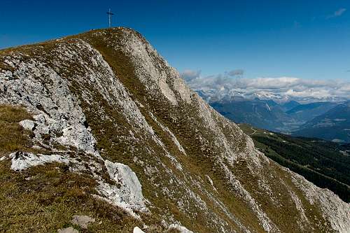 Piz da Peres / Pizzo delle Pietre summit seen from the east |
Piz da Peres / Pizzo delle Pietre is the westernmost of the six summits of Olanger Köpfe which are the northern line of defence of the Prags / Braies Dolomites against Pustertal / Val Pusteria. Together with Dreifingerspitze / Col Alc / Punta Tre Dita it forms a twin summit group, which is separated from the remainder of the Olanger Köpfe by Lapadures Joch / Ju Slapadures.
 |  |  |
On its western side Piz da Peres / Pizzo delle Pietre is separated from the popular Kronplatz / Plan de Corones (the region's most popular ski mountain) by Furkelsattel / Ju de Furcia / Passo de Furcia, a road pass which serves as the closest and highest trailhead. From here 800m have to be scaled while from any other of the possible trailheads you'll have to surmount almost twice as much.
 |  |  |
Like most of the mountains of this Dolomite Group, Piz da Peres / Pizzo delle Pietre is made up from very brittle limestone, resulting in huge impressive faces with lots of gendarmes and towers. While all other Olanger Köpfe Summits can be easily reached along their shallow south slopes, Piz da Peres / Pizzo delle Pietre has an impressive vertical south face of some 200m and thus can only be reached via its west and east ridges. both routes are somewhat exposed, especially the western one, which runs across scree and grass covered very steep slopes.
 |  |  |
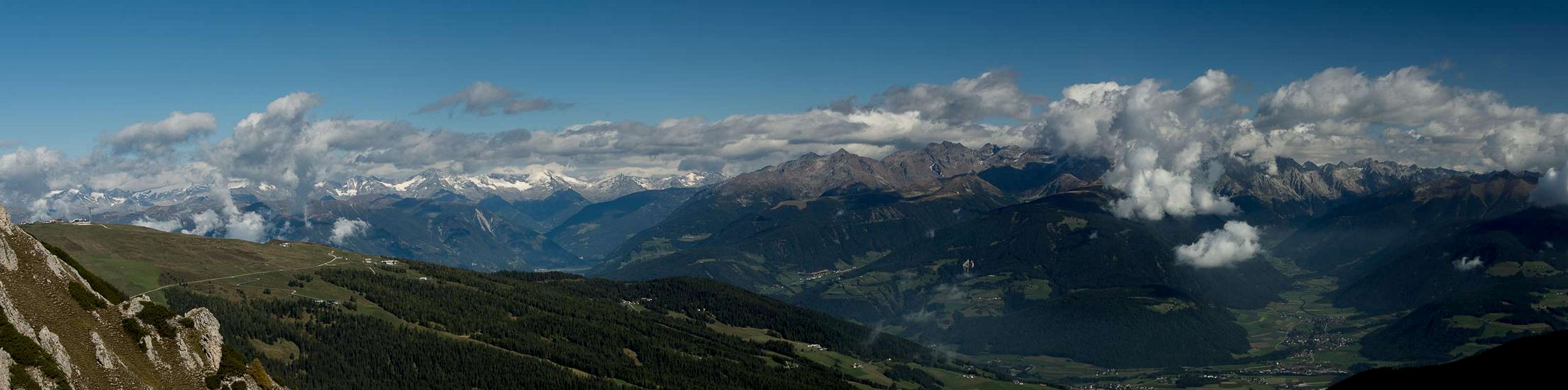
Like all of the Olanger Köpfe, Piz da Peres / Pizzo delle Pietre is a wonderful lookout mountain. It offers great views towards the northern and central Dolomites but it is its posiition high above Pustertal / Val Pusteria and the northern ascpect which draws most attention. Across the valley you can see the glaciated mountains of the Zillertal Alps and Hohe Tauern with Hochgall / Collalto taking the central position.
Northern Panorama
  |
Getting There
 Monte Paracia seen from Dreifingerscharte
The best trailhead for Piz da Peres / Pizzo delle Pietre is at Furkelsattel / Ju de Furcia / Passo de Furcia which separates the Olanger Köpfe Group from Kronplatz / Plan de Corones. Alternatives are Enneberg / Mareo / Marebbe to the west or Pragser Wildsee / Lago di Braies in the east. Both alternatives require lengthy ascents with hefty elevation gains.
From The North
- Take A22 Brenner Motorway to exit Brixen / Bressanone
- Turn off onto SS49 east to Bruneck / Brunico
- After Percha / Perca turn off left onto SP43 which takes you to the saddle
From Austria (East)
- Take A12 Inntalautobahn to exit Kufstein.
- Turn onto B178, later B161 south in direction Kitzbühel.
- At Mittersill B161 turns into B108 which heads through Felbertauern Tunnel.
- Take B108 to Lienz were you turn right (west) onto E66 which on the border crossing turns into SS49 to Bruneck / Brunico.
- After SP44 turns off north into Antholzer Tal / Val Anterselva, SP43 turns off south and takes you to Furkelsattel
From Udine
- Take A23 north to exit Carnia.
- Turn off onto SS52 which leads through several detours to Innichen / San Candido
- Turn east onto SS49 to Bruneck / Brunico.
- After SP44 turns off north into Antholzer Tal / Val Anterselva, SP43 turns off south and takes you to Furkelsattel
From Venezia
- Take motorway A27 north towards its end near Belluno.
- Turn onto SS51 towards Cortina d’Ampezzo and on to Toblach / Dobbiaco.
- Turn east onto SS49 to Bruneck / Brunico.
- After SP44 turns off north into Antholzer Tal / Val Anterselva, SP43 turns off south and takes you to Furkelsattel
Routes
From the trailhead on Furkelsattel / Ju de Furcia / Passo de Furcia there are two ascent routes to the mountain. |  |  |
- Direct ascent through Dreifingerscharte / Forcella Tre Dita
Trail No 3 starts at Furkelsattel and crosses the north slopes of Piz da Peres / Pizzo delle Pietre only slowly gaining elevation. Once beneath Dreifingerscharte / Forcella Tre Dita it splits. The right hand trail turns south and heads up the scree fields towards the saddle. It is a very steep and somewhat uncomfortable ascent due to the amount of small gravel on the route. Once in the saddle turn right and head up Piz da Peres / Pizzo delle Pietre along its east ridge.
- West Ridge
From Furkelsattel / Ju de Furcia / Passo de Furcia a path leads across the ski slopes to the north-west of Piz da Peres / Pizzo delle Pietre. It crosses a gully to the west of the mountain before combining with path No 12, heading up its west ridge. This path is steep and exposed on brittle ground!
Red Tape
 Sas dales Diesc (3026m), L'Ciaval (2907m) seen from Piz da Peres
In 1980 an area of 25680ha has been set aside for the natural Park Fanes Sennes - Prags. You are required to treat the Natural Park with care: leave animals and plants in their place, use trails (especially when mountain biking), and take the official open roads with your car.
For more information see here
Accommodation
For hotels and apartments have a look at the websites of the towns and cities of the area:Weather Conditions
External Links
Books
The Prags Dolomites / Dolomiti de Braies are not as well covered in terms of Guidebooks. The list below offers the German books I know of dealing with the area but there certainly are more, especially Italian ones.
- Dolomiten 5 - Sexten - Toblach - Prags
F. Hauleitner
Rother Verlag
ISBN: 3 7633 4199 4
- Dolomiten
P. Fleischmann
Kompass Verlag
ISBN: 3 8705 1409 4
Sextener Dolomiten extrem - Alpenvereinsführer
R. Goedeke
Rother Verlag
ISBN: 3 7633 1255 2
Maps
The most commonly used maps are the ones by Kompass and by Tabacco. The Kompass one is good as an overview map while the Tabacco one offers more details.
- Bruneck - Toblach / Brunico Dobbiaco
Kompass Map WK 57
ISBN: 3 85491 064 9
Scale: 1:50000
- Dolomiti di Braies / Pragser Dolomiten / Marebbe / Enneberg / Plan de Corones / Kronplatz
Tabacco Map 031
Scale: 1:25000