Going Back
In between junior and senior years in high school, my best friend moved from Illinois to Montana. I road-tripped to Billings the summer after I graduated to see him and did the hike with he and his family to Mystic Lake beneath Granite Peak. That was in 1985 and it was the start of my draw to this area of the world.
Eventually, my buddy ended up living in Spokane and I moved to Portland in 2000. In 2003, he and I attempted to climb Granite Peak in Montana. Altitude got me the first day and I dragged myself only about a mile up Froze to Death Plateau before collapsing where we made our camp. I remember laying there with a couple little chipmunks nipping at my elbows and me in my best Monty Python voice saying, “I’m not dead yet!”
![]()
I acclimated overnight but on the approach the next day when we got up to the path that traverses down to the saddle between Tempest and Granite, my friend BJ confessed he could go no further, the altitude was making him sick. I went ahead and ran up Tempest Mountain and then we bailed on Granite that time (although we went on to Wyoming the next day and climbed Devils Tower).
And so it was in early 2006, BJ contacted me about giving Granite another try. He had already tried a few times prior to our attempt so this one was really sticking in his craw. Over the years, he and I have done a few hikes and climbs but mostly it’s about hanging around in a cool place bs’ing with each other like we’ve done since our first days in Little League together at about age 9. (By the way, YES, we both did make the All-Star team there.)
We decided to give Granite another go in August this year and made the appropriate vacation plans with the workplaces and flight arrangements. About a month before departure date, I got a call from BJ who had been doing some work at home and dropped a sheet of drywall on his big toe, slicing it open. He was on crutches and would not be able to make it. I was bummed but then planned to still go there but do some solo hikes in the nearby mountains. I did mention it to a friend here in Portland, Karl Helser, whom I had done a few climbs with. Karl bit on the idea of Granite and before I knew it, he had made flight arrangements too. We also ended up hooking up with jimmyjay from SP who was from the area and very knowledgeable about that corner of the world.
The logistics of planning this thing and pulling it off hung by a thread though. Our flight got in to Billings at 11:40 pm. The car rental closed at midnight although their answering machine said they closed at 11:30 pm. I was reassured by an agent on the phone who said they just say that on the machine and someone will be there to get us a car whenever we get there. We also had no way of transporting fuel for our stoves via air. Karl had convinced the woman at the Super 8 motel in Columbus, MT where we were hoping to stay that first night, to have her son bring three fuel canisters from Billings for us. I’m not sure what you all think, but this seemed like too much to hope for.
As it turned out, the flight getting in to Billings was late. We landed right at midnight. The plan was to have Karl rush to secure our gear from baggage claim while I ran to try to catch a car. We both took off from the arrival gate and now I am not sure if any of you know the Billings Airport but it ain’t that big. Baggage claim was about 10 feet from the Alamo Car Rental counter and when I got there, I had to wait in line for about 15 minutes while cars were rented out by the nice girl who stayed late that night to make sure we all got cars.
So, off we go to Columbus where the nice woman behind the counter had three fuel canisters waiting for us when we checked in. Maybe things were falling into place after all?
The next morning, we met jimmyjay in Fish Tail, MT. Don’t blink or you will miss it. There is a nice shepherd mutt that wanders through town though greeting all who stop. We decided there to do the Froze to Death approach instead of Huckleberry or the East Rosebud Trail as reports were the water was plentiful and I knew the route from years before. At the trailhead, we divvied up community gear and set off about 9:30 am.
![]()
The trail was the same as I remembered it. The same bridge, the same pinnacles along the hike to Mystic Lake, the same boulders and the same beautiful Mystic Lake. The start of the switchbacks was in the same place (dammit, no escalator had been installed!) and the only thing that was different was that the trickle of water from FTD was not flowing down as before. It was a month later in the season that when I tried it in 2003 so this worried me a bit. We survived the dreaded switchbacks and got to the giant cairn where you head up offtrail onto the Plateau and it started to rain.
I was feeling pretty good altitude-wise, coming from sea level the day before. At 10,000 feet, I remarked to myself that I felt much better than 3 years earlier. That didn’t last long. The Plateau ate me up again about a mile later and I started feeling shaky. I lasted about another mile and a half before I said I wanted to camp where we were, only about halfway up FTD. Karl and jimmyjay felt good but obliged. Most camp higher up about a mile or two futher on the plateau, closer to the saddle between Tempest and Granite, but there was also a storm moving in and we wanted to get tents set up. Plus, we had found a nice water source nearby.
And we did get the tents set up………..just in time. That night, throughout most of it, was probably the worst storm I had experienced in a tent. Constant lightning, to the point where I saw a flash of light and instinctively got on elbows and one knee to limit contact points to the earth. (In retrospect, by the time you see the flash of light, you are going to be cooked anyway so what was I doing?)
![]()
And the hail! The hail pelted the tent which was bowed in on my head and back from the wind. I would try to push the tent wall away but it hurt my hand to get hit by the hail doing that. I could not unzip the door to eliminate the boat sail effect the side of the tent was having because ice would shoot in from the smallest zipper crack onto my down sleeping bag. And as you all know, a wet down sleeping bag is pretty useless. All we could do was hope the forecast was correct and the storm was passing by morning. Here is a shot from the tent door during a non-wind/hail moment at about 2 am.
The storm did pass though and when the alarm went off to get up and climb, we peered out at the snow/hail layer all around and on top of us. We figured the rock would be icy or wet and not climbable anyway. What also happened was that jimmyjay developed an altitude headache in the night and was not feeling well. We did not see anyone from the lower camps (yes, people actually camped lower on FTD that we did) heading up so we decided to use our extra day we allowed to acclimate more and let the high pressure system move in that was supposed to bring good weather.
![]()
We hiked around a little that day. Karl did a loop down to the cliffy side of the plateau and then up to the summit of Froze to Death Mountain while I went and scouted out how far we were from seeing Granite (maybe 45 minutes) and where the route would go the next morning. Jimmyjay didn’t feel well all day so when we went to sleep that night, Karl and I did not think he would be climbing with us the next day.
We woke up at 3 am and were hiking up at 3:45. Jimmyjay said he would try to catch up to us if he felt better plus he had equipment problems so Karl and I were headlamping it up in the dark. Alongside us was a couple from Poulsbo, WA who camped beside us the night prior. They left at the same time as us and we picked out way up the FTD boulders pretty much together.
The hike up went faster than I expected. The extra day really helped me and I was pretty much full speed now. We got to the traverse down to the saddle in 2 hours and passed the couple from WA (who I would find out later are SP members). Karl and I put on helmets on the loose descent and were scrambling up the 3rd class rocks in half an hour. I had thought we would go up the Class 2 route to the left of the snowfield but somehow I was funneled up the ridgeline and enjoyed the hands and feet use after the long trekking pole slog from camp.
![]()
We crested the ridge in about half an hour and then picked our way gingerly over to what normally is the snowbridge. At this time thought, it was a small dirt section with an icy pool of water next to it. From here there are two chimneys to climb and the route info said to take the left one. This meant a steep, loose dirt traverse to the left with runout exposure on a snowslope. The couple from WA had caught up to us and they went first. The woman did not like it but gently worked her way around. We followed.
![]()
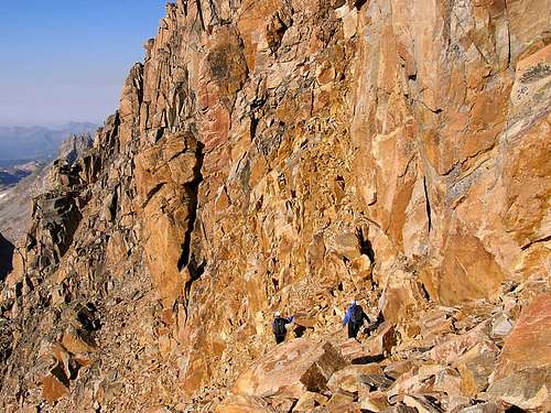
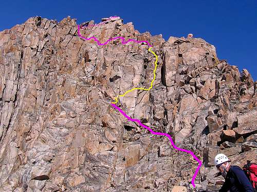
At this point, we should have looked again at the route info I had laminated in my pocket but instead we kept scrambling down left and lower around a rock rib. The actual route goes up right and up the chimney left of the X feature. We never did see the X feature that day. Instead we went around the rock rib and saw what we thought was the technical section. In actuality, we were still a ways away which would explain why it didn’t quite match up with the photos (I was now looking at the laminated route info but thought I was in a different spot.). We ended up trying a few gullies and finally, one of them I went up led back to the route. We knew this because now other parties were joining us on the climb and confirmed it.
About this time, we saw jimmyjay above us and scrambling up. We met up with him on the 3rd class traverse over to the actual “technical” section. There were about 10 of us bunched up at the beginning of the 5th class chimneys. I ended up harnessing up first and led the first group. It’s an easy traverse and then blocky climb with some exposure that some just free solo up (4 kids did so later in the day). Most rope up here though and I linked the two pitches together to the second set of webbing. I belayed up jimmyjay and Karl and then we spent some time trying to figure out the correct way to traverse left over below the keyhole. After much speculation, we settled on a somewhat exposed traverse with a couple of 4th class short grooves up that worked and that I think is the correct route. Once below the keyhole, the scramble is straightforward up and around the backside to the summit.
![]()
The views were amazing and I think we could see from Hawaii to Delaware from up there. Two guys from Connecticut joined us and then 3 others. We did not spend much time up there as it was now 1 pm and we had a long way to go back. On the scramble back more groups passed us on their way up. We all got bunched up at the rappel and with the others knowing the correct way back, we followed and did 3 raps on the way back. One down the “technical” section (Note: a 60 meter rope just barely is enough for the rap down.), another down a 4th class chimney we had scrambled up and the last down the X feature chimney we missed. Of course, we had dropped our packs in the part where we should not have been so Karl and I had to scramble back to find them.
![]()
By the time we got back to the snowbridge, we filtered some water and jimmyjay went ahead of us while we hiked back pretty much again with the couple from WA.
![]()
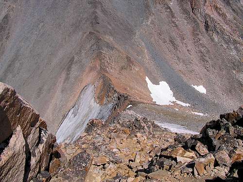
On the traverse back, we saw jimmyjay up ahead with two goats on the saddle and then as we climbed up the traverse back to Froze to Death Plateau, we could see an afternoon storm rolling in. We got some snow on the way back but the clouds with lightning skirted us to the south and stayed mostly over Mt. Wood. It was a long, slow, foot-throbbing hike to camp but we made it by 6:50 pm, just about 15 hours from when we left.
![]()
But the story doesn’t end there, oh no! You see, our flight back to Portland was the next day around 1 pm. We still had 11 miles to hike out, then drive back to Billings and get there early enough for the new baggage screening for liquids. We packed up camp immediately and started hiking out about 8 pm. Jimmyjay again was a blur to us as he bounded ahead of our lard-asses. Karl and I did enjoy a nice hike through the middle of a goat herd that could not have cared less if we were in their midst or not. Three of them followed us a while waiting for some urine-salt but we did not oblige. It grew dark and before we got off FTD Plateau, we were avec headlamps again.
![]()
The slope down to the trail is much longer than one expects (or at least we did) and we had not paid much attention to it on the way up. We kept going down and down in the dark. It seemed more bouldery than before so we wondered if we were off route. Karl pulled out the GPS and used waypoints and a compass to guide us while I checked the altitude. At just about the right altitude and just slightly east of where we went up, we hit the trail. I could have sworn we were already halfway down to the lake but it was just a case of things being different than you remember. We found jimmyjay on the trail shortly after and we all hiked down in the dark. Halfway down the switchbacks, we took a break and watched satellites stream across the Milky Way above. It would have been very nice except for the sore feet and knowledge we were still a long way from the car.
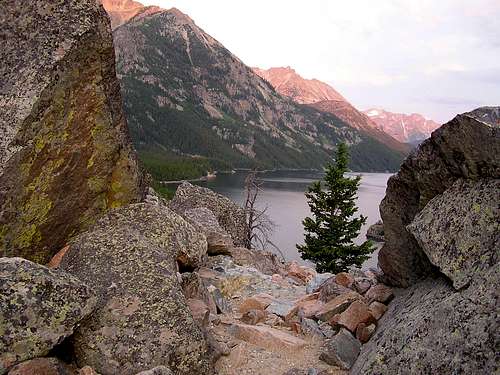
By 1 am we were back at the lakeshore and could go no further. We put down sleeping pads on the gravel beside the lake and slept until 6 am. We got up and headed out in the dawn light. Those guys were faster than me so they went ahead. I hiked out the trail from the lake solo, the same way I had 3 years earlier when I was slower than BJ. The feet, knees and back didn’t hurt so bad this time due to the summit. But I got a bit melancholy on the hike out thinking it would have been nice to have BJ here. This was really his state and his idea to climb it and I felt like I sneaked in and stole a summit from him. I took a lot of photos on the hike out because I have no idea if I am going to do this one again at some point with him or if it is the last time I’ll be there. The dawn was beautifully pink on the rocks and the greens were greener on the aspens and spruce. I really enjoyed that hike out and near the end I ran into a large deer on the trail. He sort of looked at me and slowly walked out into the creek to let me pass. I appreciated the sendoff from the locals!
![]()
![]()
We said goodbye to jimmyjay at the trailhead and due to construction on the road back to Columbus, we had to go straight to the airport without breakfast. We made it in time though and caught some food at the airport before the flight back. Boy I felt sorry for the people who sat next to us on that Horizon Airlines flight with our 4-days-out stench. That’s ok though we had a great time and was nice to meet a new SP’er in jimmyjay. I am sure Karl and I have many more climbs ahead and was sure glad he was able to join me on this one to finally get it done.


Comments
Post a Comment