
-
 26571 Hits
-
 80.87% Score
-
 13 Votes
|
|
Area/Range |
|---|---|
|
|
42.63873°N / 103.32783°W |
|
|
Overview
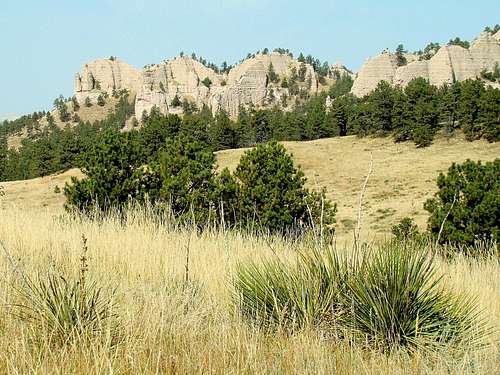 Unspoiled Beauty of some of Ponderosa's Buttes
Nebraska's 4,000-acre Ponderosa Wildlife Management Area (WMA) came into existence in 1965. The land has been designated for public use - hunting, fishing, hiking, climbing and bird watching. There are only a few old roads in the WMA, but the only vehicles allowed on them are state fish & game units. This rarely happens, allowing most visitors lots of quiet solitude. Crown Butte, at the north edge of the Ponderosa WMA, is the only named summit in the area. At 4,370 feet, it is the most distinctive landmark in the WMA.
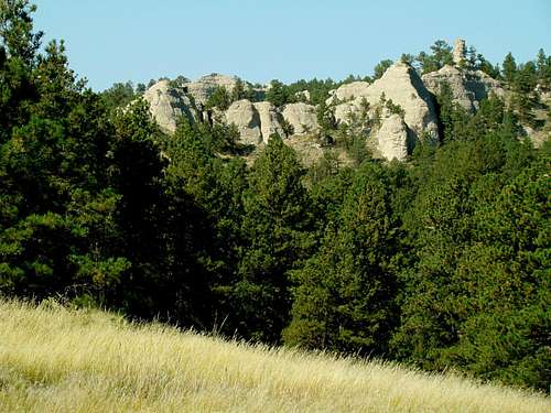 Rock Formations Near the Trail
Like the rest of the Pine Ridge, the WMA is characterized by steep buttes, canyons, ridges, sandstone rock formations, and small streams. Thick ponderosa pine forest covers much of the area, though there are some stands of cottonwood, aspen and ash. Unfortunately, the WMA has experienced serious fire damage over the last 35 years with three major forest fires. The first was the McIntosh Fire in 1985 and the second was the Sawlog Fire in 2000. The third, 2012, was by far the worst, with almost everything north of the Rim of The World Trail destroyed.
The area does not see many visitors, except during firearms deer hunting season and wild turkey spring hunting season. Besides an abundance of deer and wild turkeys, other wildlife seen in the WMA includes bighorn sheep, some elk, mountain lions, coyotes, and the common mix of porcupines, raccoons, and skunks. Eagles are sometimes seen floating high above the cliffs in the area. The Ponderosa WMA Office is the headquarters for all eight WMA’s in Nebraska’s Pine Ridge region. Besides the Ponderosa WMA, the other WMA’s include the Petersen WMA, the Metcalf WMA, the Chadron Creek WMA, the Bordeaux Creek WMA, the Gilbert-Baker WMA, the Bighorn WMA and the Fort Robinson WMA (not to be confused with Fort Robinson State Park).
Getting There
To reach the WMA and the trailhead, the easiest way is to take Highways 2 & 71 south 2 1/2 miles from Crawford, then go east on Sawlog Road 3 3/4 miles. Sawlog Road will become Squaw Creek Road about half-way there. On the north side of the road is an old 2-track road with a cable barring access. That is the trailhead. If you do not care to park along Squaw Creek Road, you can go 1/2 mile further east and look for the WMA headquarters on the right. There you can park, and if you can find anyone in the office, you can get information.
Red Tape
There are no fees to use the Ponderosa WMA at this time. No camping or fires are allowed in the WMA. The WMA regulations are posted at their office just up the road from the Rim of the World Trailhead. Please be advised that this area is very hunting-oriented (in-season, of course) and while you are allowed to carry firearms, there is a catch. If you carry a gun during a hunting season, and that gun is one of the types specified for use in that particular season, you better have a valid hunting permit. Otherwise you will get a hefty fine.
Hiking Routes and Options
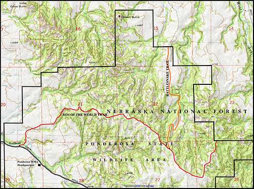 Ponderosa Wildlife Area Map
Due to all the burned trees, especially in the northern half of the WMA, off-trail hiking is discouraged. Hiking across meadowland is not a problem, but the snags in the burned-out forest can be deadly. Also, the timber that is already fallen makes hiking a very slow and wearisome process. So, confining most of your hiking to the two main routes through the WMA and off-trail routes through non-burn areas is probably in your best interest. The Rim of the World Trail is the primary route through Nebraska's 4,000-acre Ponderosa Wildlife Management Area (WMA). The trail is actually an old 2-track road long abandoned by the county for being too steep. The only vehicles allowed on the trail are state fish & game units. The Rim of the World Trail is about 4 miles long, from the trailhead to the WMA boundary. Hikers climb from 3,960 feet at the traihead to about 4,380 feet at the high point on the trail just past the halfway point.
Crown Butte & The Rattlesnake Trail. Not far from the WMA end of the trail, hikers will come to a junction with the Rattlesnake Trail, which heads in a mostly northerly direction on a gentle slope down over 300 feet into a rocky canyon and intermittent stream bed. The Rattlesnake Trail is just over 2 miles in length, ending at a northern edge of the WMA. It's beauty is the easy access it gives to the canyon bottom, allowing for lots of exploring. The Rattlesnake Trail will also take you in the direction of Crown Butte, though keeping you east of it. The map in this section shows that to hike to Crown Butte from the Rattlesnake Trail will require bushwhacking about 1 mile northwest over some meadows and through the stream bed. The scramble up Crown Butte is at least Class 3. There is a summit log there in a hollow place in the summit block. If you make it to the summit, you will see that few people visit the Crown Butte summit each year. The distance from the Rim of the World trailhead (5.5 miles one-way or greater, depending on your bushwhack route) plus the steepness of the upper slopes keep most people away. Anyone who chooses to hike this area should be advised these trails have no markings, so PLEASE study your maps carefully! A good topo map along with your national forest map is essential. GPS is a great idea, though do not depend entirely on it. It's also worth your time to track down one of the busy staff members of the WMA for tips on your hike.
Safety
 Crown Butte before the 2012 fires
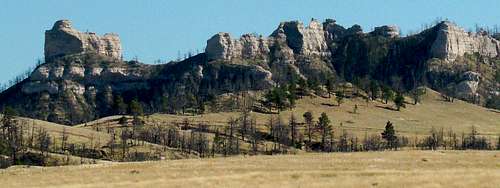 Crown Butte after the 2012 fires
The point cannot be overemphasized that this is a very remote and rugged area. Obviously, fire dangers are very real, as are the dangers of falling dead trees in old burn areas. People who are used to hiking in more developed areas of the country could get lost if they do not have a very clear idea of where they want to go and how they should get there. There are mountain lions and rattlesnakes to add to the dangers of falls or getting lost. Ticks are a major problem in spring and summer, so good repellent is important. Please leave your hiking plans with someone who will check on you. If you can't find anyone, please contact the Dawes County Sheriff's Office at (308) 432-3025. Please also be aware of Nebraska hunting seasons, and if you choose to hike then, wearing an orange vest is an investment in your safety.
Camping Contact Information
The nearest campgrounds are located in Crawford and at Fort Robinson, 3 miles west of Crawford. For the latest campground information, you can reach the Crawford Chamber of Commerce at (308) 665-1817 or Fort Robinson at (308) 665-2900.
When to Visit the Ponderosa WMA
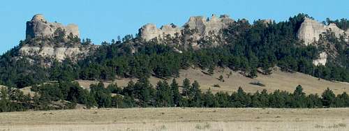
 Crown Butte's East Side
The Ponderosa WMA is open year-around. The officials there strongly caution hikers and climbers about hunting safety during Nebraska's deer and wild turkey seasons in particular, but all seasons in general. For more information on Nebraska's hunting seasons, you can view information online by clicking on this site: Nebraska Hunting Seasons Information
You can reach the Ponderosa WMA by phone at: (308) 665-2924.
Weather can make or break a trip to the WMA, so for the latest forecasts and conditions, click here:
Ponderosa WMA - Crawford Area Forecast & Conditions