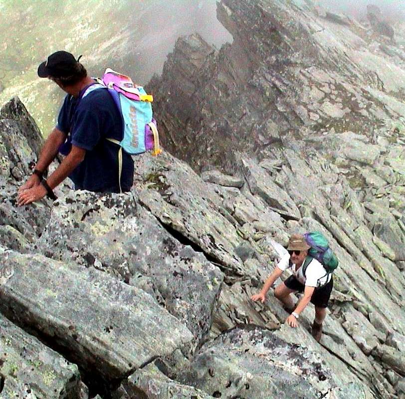
Causes more or less unknown lead us to attend the same places: it can be a valley, a walloon, a mountain, a hill, a lake, or simply a place where we go for a Sunday walk with children and family. Or even by yourself. In places we know up from early youth, or that we discover later on in the flow of time. A mysterious magnet that attracts us to the first impact, there "Paste" and then maybe falls by the wayside. This is the
Human Psyche and only an analysis at the back can give us some answers. Maybe inaccurate, impartial, incomplete and always subjective. Or in common with others, and then the question becomes more interesting:
because we become Visitors, Hikers, mountaineers and Climbers or attending assiduously the usual places? The answer is simple and complex at the same time. When we were very young was the exploration of places close to home that attracted our fancy trying the comparison
between Imagination and Reality. Typically this last always gave answers more munificent and rewarding than the first, a little contradicting what Coleridge says he wants to always have an idea a priori to explain and understand events. For him, the
"Noumenon" should take precedence over the
"Phenomenon". But we see that in this context the nature he is not seeking to play, completely subverting the outcome of the factors. As you can imagine a priori, always surprises you and your dear ideas are totally subverted. This Mystery makes it more fascinating and forces you to acknowledge that you, element seemingly more
"plastic", in truth you are more granite in your ideas with respect to an element which sometimes appears to be immobile, inorganic and incomprehensible in his way of being statuary or that repeats forever. And you do not need to explore Mars, given the distance, completely overturns all human hypothesis. Just look around your house to discover the wonders of which you were not aware of. So when we were kids and not having a license, means money or just for the cable car station, there looking for refuge, starting directly walk, in the mountains above our house: the Group of Emilius
(3559m) with the nearby
"maids" Becca di Nona
(3142m), Testa Nera
(2820m) and Punta della Valletta
(3090m) was thoroughly explored, but it was also
"traveling" and always starting from our house
(565m) exceeded the Baltea going to go up north to Mont Fallère
(3060m) or Becca of Viou
(2856m), with great views over the City of Aosta and incommensurable views of the circle of the Alps. A wonderful discovery that left us speechless. But when we slipped
a little Devil in the brain "concept of mass" we began to snub the same, or to not find too many people and destined the hardest routes to climb and unusual, where it was virtually impossible to find the person. At most the Summit, if they were not already gone. Then we discovered the Punta Rossa of Emilius
(3401m) and Pic Garin
(3461m). Here again we became absolute masters of the territory. They were
"our" and that's it. From the top they looked
"the other". A few, actually. Equally it was for the Rock Gym Chenaux in the neighboring Municipality of Pollein and at the end of the Gorgias of Dard, where we were going to play by mid-sixties our daily training. Even that was ours, we had discovered us in spite of a large inscription at the bottom which read the SMA (Alpine Military School); but the
"Alpini" had been missing for a long time or at least we do not we never met. They were the ghosts of the past and when we found a rusty nail him we put the date so prehistoric Twenties, Thirties maximum. The large roofs equipped with expansion nails were the work of Lucio Monaco of Aosta, a student and admirer of great Valpelline Guide Angelo "Angelino" Bozzetti; but Lucio was gone and when he arrived in bicycle Angel, after the shift in Cogne Steel Plant, watched him with its nose pointing upwards. He was allowed to enter our territory, to the others, the occasional really, no. We watched them crooked, as if they were the Invaders. Then
"Invaded by you become Invaders" inevitably expanding and are seeking new destinations.
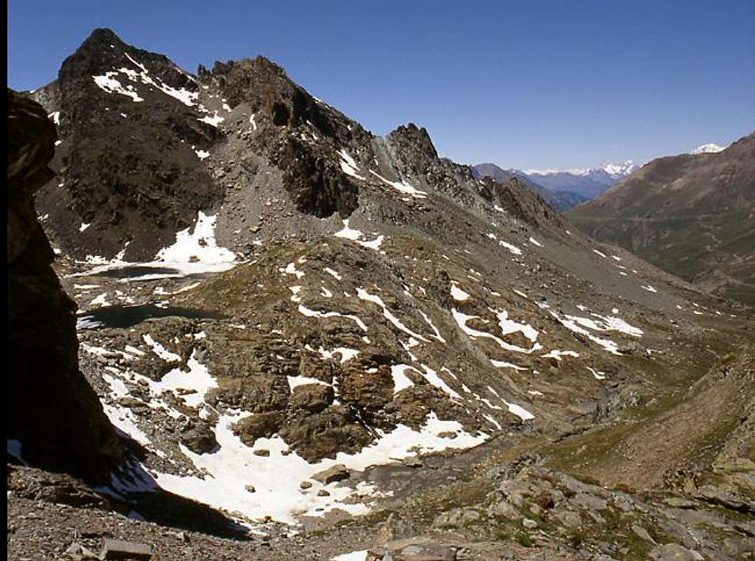
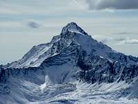
![]() "Invaders at the beginning of Grand Paradiso Mountain Chain?",
"Invaders at the beginning of Grand Paradiso Mountain Chain?",
by emilius
Then came the discovery of the Gran Paradiso and satellites, and then were carried great rides up and down to the Rifugio Vittorio Emanuele II°. A fashion of the times. Following the Chain of Mont Blanc, but we had already visited the well Monte Rosa, with Klein Matterhorn, Breithorns, Castor, Lyskamms, Punta Zumstein and Dufour. They were far away, but strikes less fear into us. Over time we have abandoned almost completely. The great misfortune in the death of Bozzetti Aiguille Noire at the beginning of 1967 and Garzotto and Junod Croux in the Fall of 1969 left us alone. The group broke up dispersing into other interests and with other companies. I painstakingly taken with the Mont Blanc de Tacul. With new companions "Peppino" Lamazzi and Marco Cossard said "Crevassino" I began all over again by going to
"tease" the Emilius doing the full tour at its base with its ascent, eighteen days after getting married. During the honeymoon, the Montenvers I saw Koreans rope to the Bonatti Pillar on the Petit Dru and I had come to some doubts about the choice. Life goes on for us and it had become fashionable in the Tacul August holiday. Until 1974 In the meantime, he had appeared Camillo Roberto Ferronato (so strong physically as fast knowledge of the mountain. A real
"Animal", coming from weight lifting and bob) with which I started doing rope. A partnership that lasted from 1972 to 1987, when he
"betrayed" by Franco Lucianaz to look for minerals. But it was already a little bit of time that the needle of his passion hung more and more towards this choice. It was no use calling him offensively
"hunters of stones". A
"Disease" incurable really! That was his new road. I learned to go more and more alone, until he began a new partnership with Emilio Bertona (
emilius in summitpost): since 1998 until 2010, the year of his death, as he descended alone from Mont Zerbion. They were years of continuous hiking with considerable frequency, even in the winter and through the entire Aosta Valley in a
"crescendo" of ascents, excursions by snowshoes which he visited all the valleys and walloons, even the most remot, hidden and often unknown to us. Then again, only more and more lonely. Until July 14th, 2008 when, breaking the Achilles tendon, I have finished the
"work of vagabond". Now my new partner is my nephew Pietro with whom I "climbed" three times the terrible Mount St. Julien. Good thing the power to start!
But what hits everything with the Ponton Tower? In the Walloon Urtier I went for the first time in September 1974 with Camillo going to Punta Tersiva from the Alp Invergnoux or Hevergnes. It seemed to me a walloon desolate and abandoned, despite the long dirt farm road, going from Lillaz, it runs like a snake crawling on the side of the torrent and then splits in the highest part in several branches. I did not like and I found it boring. But on the Summit had recovered the Book of Peak, the pages of which the storm was sweeping in all directions and under the hill we found some edelweiss gigantic. It was enough to make it less unpleasant day. Going flaw Tower Lavina August 22th, 1982 I passed, from Acque Rosse Walloon, through this again but, you know, everything is different down (it was the period of keratitis or eye disease of the chamois, one was dead as a doornail in the lake). I'm back in late August of 1982 with a group of friends who climbed the Normal Via, and those who, like me and "Peppino" the West Ridge. Impression? the same, or of desolation. At the end of July 1985, always with "Peppino", let's go for a complete traverse of the two Penne Blanche, from Mount Creya towards the Invergneux Hill, passing Tête of Money and Pointe Coupée,: ascent and descent from the Walloon of Grauson for the same. Looking from the top Urtier Walloon the same impression, but in a subsequent redo the same direct descent from the crossing between the two Penne Blanche Summits on Urtier: horrible and sunny desolate traverse among dry stony couloirs and steep grassy slopes above Taveronna, Seutse and Gueula Alpages. This vicissitudes were authorization for definitely and decisely exclaim:
"Never again!"
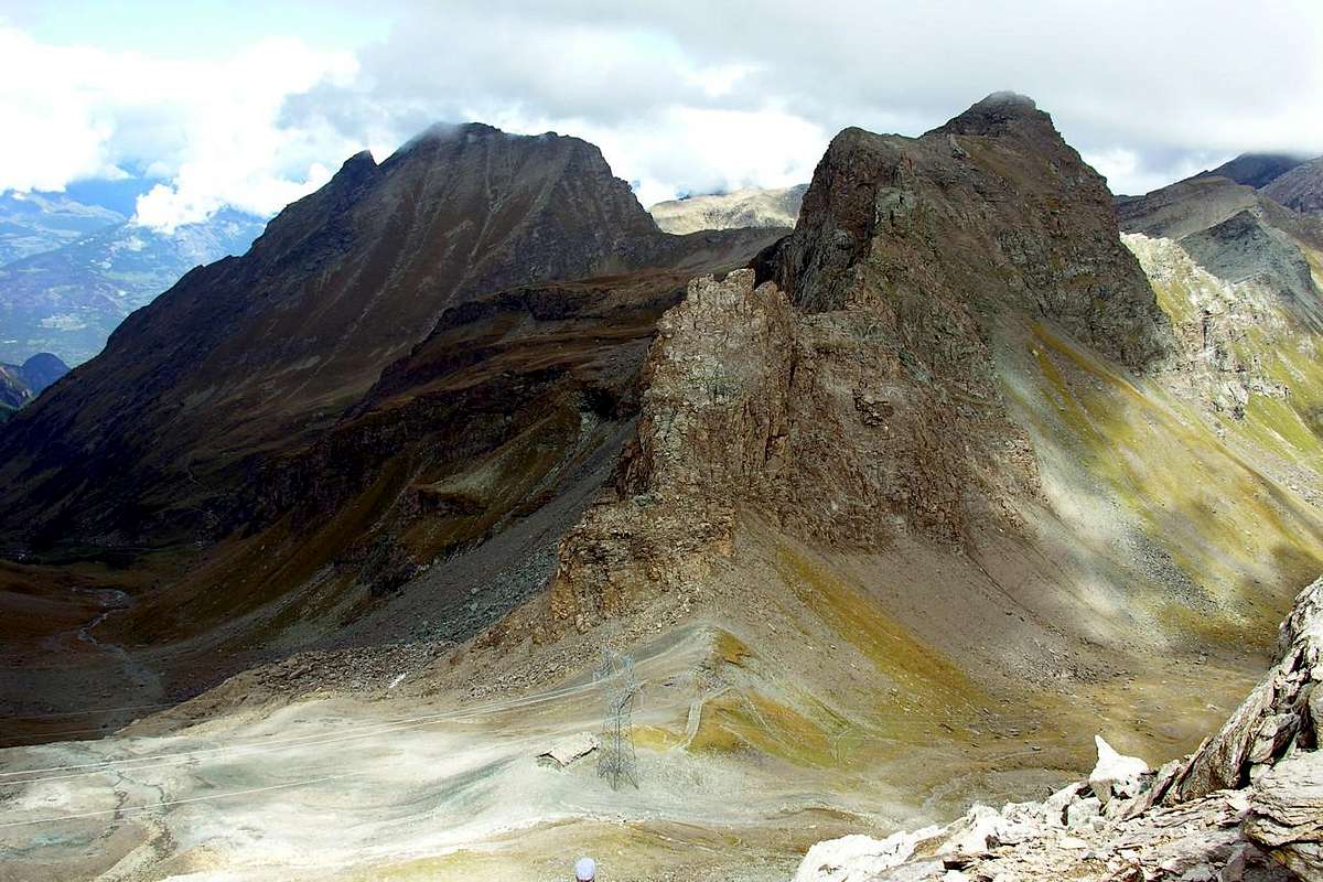
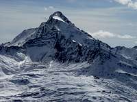
![]() The rocky pyramid of Tour Ponton from Southwest neighbor Ponton Alpage and Loch,
The rocky pyramid of Tour Ponton from Southwest neighbor Ponton Alpage and Loch,
by marco87
Cause più o men sconosciute ci portan a frequentare i medesimi posti: può essere una valle, un vallone, una montagna, un colle, un lago o semplicemente una località dove la Domenica andiamo a fare una passeggiata con bambini e famiglia. Oppure anche da soli. In posti che conosciam fin dalla prima giovinezza o che scopriamo più in là nel tempo che scorre. Una calamita misteriosa che ci attrae fino dal primo impatto, c'
"incolla" e poi magari cade nel dimenticatoio. Questa é l'
Umana Psiche e solo un'analisi a posteriori ci può dar risposte. Magari inesatte, imparziali, incomplete e comunque sempre soggettive. Oppure da spartire con altri, ed allora la domanda diventa più interessante:
perché diventiam Visitatori, Escursionisti, Montanari od Alpinisti che frequentano con assiduità i soliti luoghi? La risposta é nello stesso tempo semplice e complessa. Quando eravam molto giovani era l'esplorazione dei posti vicino a casa che attirava la nostra fantasia cercando il
confronto tra l'Immaginazione e la Realtà. In genere quest'ultima dava sempre risposte più munifiche e gratificanti della prima, contraddicendo un poco quel che afferma Coleridge tal da volere sempre un'idea aprioristica onde spiegare e comprendere gli avvenimenti. Per lui il
"Noumeno" deve avere precedenza sul
"Fenomeno". Ma si vede che in siffatto contesto la Natura non stà al giuoco, sovvertendo completamente l'esito dei fattori. Per quanto tu puoi immaginare a priori, sempre ti sorprende e le tue care idee vengono totalmente sovvertite. Questo Mistero rende tutto più affascinante e ti costringe a prender atto che tu, elemento apparentemente più
"plastico", in verità sei più granitico nelle tue idee rispetto ad un elemento a volte apparente come immobile, inorganico ed incomprensibile nella suo modo d'essere statuario o perennemente ripetivo. E non c'é bisogno d'esplorar Marte che, vista la lontananza, ribalta completamente ogni umana ipotesi. Basta guardare dietro casa tua per scoprire meraviglie delle quali non eri a conoscenza. Così, quando eravam ragazzi e non avendo patente, mezzo o semplicemente soldi per la Cabinovia, ci rifugiavam, partendo direttamente a piedi, sulle montagne sopra casa nostra: il Gruppo dell'Emilius
(3559 m) con le vicine
"ancelle" Becca di Nona
(3142 m), Testa Nera
(2820 m) e Punta della Valletta
(3090 m) veniva minuziosamente esplorato: ma s'andava anche
"in trasferta" e partendo sempre da casa nostra
(565 m) s'oltrepassava la Dora Baltea per andare a salir a Settentrione il Mont Fallère
(3060 m) o la Becca di Viou
(2856 m), con grande panorama sulla Città di Aosta e con incommensurabile vista sulla cerchia dell'Alpi. Una meravigliosa scoperta che ci lasciava attoniti. Ma quando
un Diavoletto c'infilò nel cervello il "concetto di massa" incominciammo a snobbar le medesime, oppure per non trovar troppa gente destinavamo la salita a vie più difficili ed inusuali, dov'era praticamente impossibile incontrar gente. Al massimo sulla Sommità, se non se n'eran di già andati. Poi scoprimmo la Punta Rossa dell'Emilius
(3401 m) e la Punta Garin
(3461 m). Qui diventavamo nuovamente padroni assoluti del territorio. Erano
"nostre" e basta. Dall'alto si guardavano
"gli altri". Ben pochi, per la verità. Ugualmente era per la Palestra di Roccia di Chenaux, nel vicino Comune di Pollein ed al termine della Gorgia del Dard, dove andavamo a svolgere da metà degli Anni Sessanta il nostro allenamento quotidiano. Anche quella era nostra, l'avevam scoperta noi a dispetto d'una grande scritta in calce che recitava SMA (Scuola Militare Alpina); ma gli Alpini eran scomparsi da un bel pò od almeno noi non li avevamo mai incontrati. Erano dei Fantasmi del passato e quando trovavamo un chiodo arrugginito lo datavamo in modo preistorico: Anni Venti, massimo Trenta. I grandi tetti attrezzati con chiodi ad espansione erano opera di Lucio Monaco di Aosta, allievo ed ammiratore della grande Guida Angelo "Angelino" Bozzetti; ma anche Lucio era sparito e quando arrivava in bicicletta Angelo Bozzetti, dopo il turno nello Stabilimento Acciaierie Cogne, lo guardavamo col naso rivolto in sù. A lui era permesso d'entrar nel nostro territorio, agli altri, veramente occasionali, no. Li guardavam storto, come fossero Invasori. Ma poi
"da Invasi ci si fa Invasori" inevitabilmente allargando il raggio d'azione cercando nuove mete.
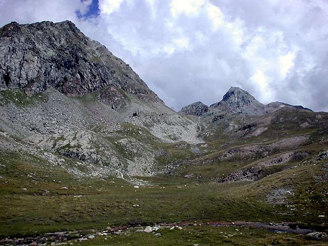
![]() From Hevergnes Pass to Southwest on Apostles Group in Gran Paradiso Chain,
From Hevergnes Pass to Southwest on Apostles Group in Gran Paradiso Chain,
by emilius
Di conseguenza avvenne la scoperta del vicino Gran Paradiso e satelliti ed allora si effettuavano grandi corse sù e giù per il Rifugio Vittorio Emanuele II°. Una moda dei tempi. A seguire la Catena del Monte Bianco, ma già avevamo ben visitato il Monte Rosa, con Piccolo Cervino, Breithorns, Castore, Lyskamms, Punta Zumstein e Dufour. Erano lontani, ma incutevano meno timore. Nel tempo l'abbiam abbandonato, quasi del tutto. Le grandi disgrazie con la morte di Bozzetti all'Aiguille Noire all'inizio del 1967 e di Garzotto e Junod alla Croux nell'Autunno del 1969 ci lasciarono soli. Il gruppo si smembrò disperdendosi in altri interessi e compagnie. Io ripresi faticosamente con il Mont Blanc de Tacul. Coi nuovi compagni "Peppino" Lamazzi e Marco Cossard detto "Crevassino" incominciai tutto da capo andando a
"prendere in giro" l'Emilius facendo il tour completo alla sua base con relativa salita, diciotto giorni dopo essermi sposato. Durante il viaggio di nozze, ai Montenvers avevo visto una cordata di Coreani dirigersi verso il Pilastro Bonatti al Petit Dru e m'era venuto qualche dubbio sulla scelta testé effettuata. La vita continua ed era diventato per noi di moda il Tacul a Ferragosto. Fino al 1974. Nel frattempo era apparso Camillo Roberto Ferronato (tanto forte fisicamente quanto digiuno di conoscenza della montagna. Un vero e proprio
"Animalo", che proveniva dalla pesistica e dal bob) con il quale iniziai a far cordata. Un sodalizio che durò dal 1972 al 1987, quando mi
"tradì" con Franco Lucianaz per andar cercar minerali. Era già da un pò di tempo che l'ago della sua passione pendeva sempre di più verso sta scelta. Non serviva a nulla chiamarli offensivamente
"cacciador de sassi". Una
"Malattia" veramente incurabile! Quella era lor nuova strada. Imparai ad andar sempre più da solo, finché iniziò un nuovo sodalizio con Emilio Bertona: dal 1998 al 2010, anno della sua morte avvenuta mentre scendeva da solo dallo Zerbion. Furono anni di continue escursioni con una notevole frequenza, anche in inverno ed attraverso l'intera Valle di Aosta con un
"crescendo" di salte da far visitar vallate e valloni, anche quelli più remoti, nascosti ed a noi sconosciuti. Poi nuovamente solo, sempre di più. Fino al 14 Luglio 2008 quando, rompendo il tendine di Achille, ho chiuso col
"vagabondaggio". Ora il nuovo compagno di cordata é il nipotino Pietro con il quale ho "scalato" già tre volte il Saint Julien. Buona cosa il poter ricominciare!
Ma cosa centra tutto ciò con la Torre Ponton? Nel Vallone dell'Urtier c'ero andato per la prima volta con Camillo nel Settembre 1974 andando alla Punta Tersiva dall'Alpe dell'Invergneux o Hevergnes. M'era sembrato un vallone desolato ed abbandonato, nonostante la lunga strada poderale che, salendo da Lillaz, lo percorre come un serpente strisciante affianco del torrente e poi si divide nella parte più alta in diverse ramificazioni. Non m'era piaciuto e lo trovavo noioso. Però sulla Sommità avevo recuperato il Libro di Vetta, le pagine del quale la tormenta stava spazzando in tutte le direzioni e sotto il colle avevam trovato delle stelle alpine gigantesche. Era sufficiente per rendere meno sgradevole la giornata. Scendendo dalla Torre di Lavina il 22 Agosto 1982 son passato nuovamente, arrivando da quello di Acque Rosse, attraverso questo vallone ma, si sa, in discesa tutt'é diverso (era il periodo della cheratite o malattia agli occhi dei camosci; uno era morto stecchito in riva al lago). Son tornato a fine Agosto del 1982 con un gruppo di amici: chi saliva la Normale e chi, come io e "Peppino" la Cresta Ovest. Impressione? la medesima, ovvero di desolazione. A fine Luglio del 1985, sempre con "Peppino", andiamo a fare la traversata completa del Penne Blanche, dal Monte Creya al Pas d'Invergneux: Salita dal Vallone di Grauson e discesa pel medesimo. Guardando dall'alto l'Urtier stessa impressione, ma in una successiva rifaccio la stessa traversata con discesa diretta tra i due Penne Blanche sull'Urtier: orrenda, con un'assolata traversata al di sopra delle Alpi Taveronna, Seutse e Gueula tramite ripidi canaloni rinsecchiti e costoloni erbosi. Ce n'era abbastanza per autorizzare ad esclamar perentoriamente:
"Mai più!"
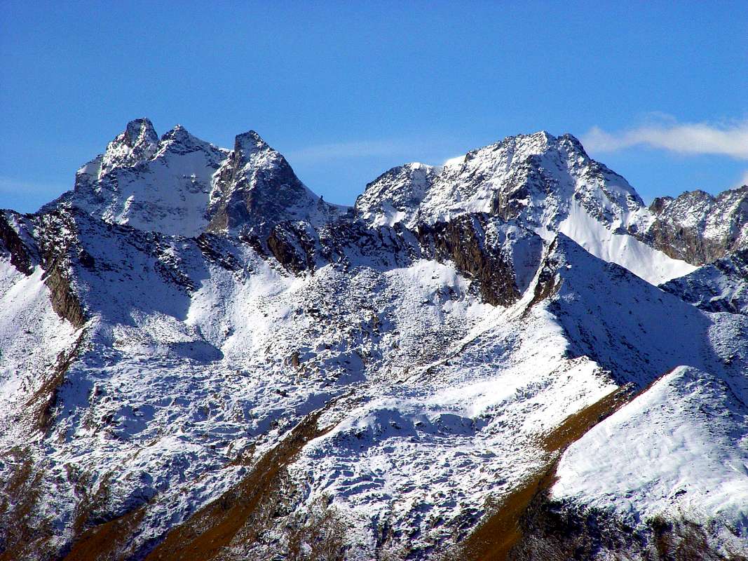
![]() Urtier Northern Side below Penne Blanche watershed with to the far right shaded Ponton Tower,
Urtier Northern Side below Penne Blanche watershed with to the far right shaded Ponton Tower,
by livioz
Pontor Tower & Surroundings
![]() "From Arietta Pass & Miserino's Lochs to Urtier",
"From Arietta Pass & Miserino's Lochs to Urtier",
by Gino Bolfo
In fact the second time, dropping from Punta Tersiva, we also took the fine because we were not equipped with the transit permit. The
"ranger", who escorted the two "Api Piaggio" packed with steinbocks killed by poachers, gave us a heavy penalty. To us that there were going to climb the mountains and photograph animals and flowers. I was angry and not just the threat of a complaint the next day at the Prosecutor's Office for complicity and protection of the same. Became white as a sheet in the face and fell silent. "Crevassino", who was the owner of our car and then paid the fine proved more malleable, mediated and paid the same. Glad he ... These dirt farm roads that are being built with money from taxpayers and then all of us put a sign of the driving ban exceptions! Why not pay the construction by the same owners? Then also put a gate with a lock. But not so! Instead we protect the poachers who kill the poor animals (from the body and under the tarps came out with their heads dangling horns gifts, there were many), just because crossing the Torrent Urtier are outside of the National Park of Gran Paradiso. But, you know, the ibex hunting is prohibited in any case, anywhere. For this factor Urtier I became more and more obnoxious, also because the walk the same walk starting directly from Lillaz Village
(1615m) is already a pretty, very long and grueling walk-excursion.
Had no desire to go back there.
Instead go back dozens of times. To go to Punta Tersiva, but also to climb these disconsolate peaks that constitute the district. On average are
around 3100 metres, they not have excelled lines and even vertiginous walls. However, in their loneliness, they possess a charm: that of the genuine things and pristine. Their knowledge is primarily aimed at four aspects:
1)- the classic ascent of the Tersiva from Cogne,
2)- the traditional crossing to the Valley of Champorcher through Fenêtre (now back in vogue with the construction of the Shelter
"Dream of the Shepherd" that allows connection to Miserin sanctuary and nearby loch),
3)- the ancient passages through the Hills Acque Rosse, Arietta and Bocchetta della Scaletta for the transport of the ore of iron to the Piedmont and for the famous and ancient Procession of San Besso,
4)- a visit to the beautiful Lakes Miserino.
"From the lower to the upper Urtier Valloon",
by livioz
But for the Summits? Nothing or little more. We have to wait Georges Yield in
"The Mountains of Cogne (Climbers Guide)", London 1893 and in
"Scrambles in the Eastern Graians 1878-1897", London 1900 Editions again by Fisher-Unwin, gives us of the information is mainly with the first ascent of the Northwest Ridge of Punta Nera Miserino's. Between these two books are the fundamental
"Guide of the Western Alps and Pennine and Graian Alps" to the work by Giovanni Bobba and Luigi Vaccarone, Edit. C.A.I. Section of Turin, May 25th, 1896 in Turin, where pages are treated 36/9 the Hills
"Ponton, Pontonnet, Fenetre de Champorcher, bassa di Peratza, Balma, Arietta or said Nouva, Miserin, Bocchetta della Scaletta and Rancio and Eaux Rouges". The same for the Summit sent us pages with 68/9
"Torre Ponton, Becco Costazza, Roccie della Balma, Testa della Nouva, Punta del Rancio and Touret di Lavina, Punta Nera, Punta Acquarossa, Punta Lavina". Something we find him again in
"Gran Paradiso National Park", by Emanuele Andreis, Renato Chabod and Mario Carlo Santi, Edit. C.A.I. / T.C.I. 1938, 1963, and 1980 where we find on pages 542/8 details of the stretch of the ridge from the Tower of Lavina reach Colle dell'Arietta. But this guide will stop here without dealing with the high head of Urtier and we have to wait, unless local publications, the Guide
"Emilius Rosa dei Banchi Park M.Avic", by Giulio Berutto and Lino Fornelli, same Publisher March 2005, to have more precise descriptions of this area. From pages 164/71 we have a first detailed excursus that from Pontonnet Tower to the Arietta Pass, treating Torre Ponton, Bec Costazza, Cima di Péradza and Testa della Nuova. But of the Ponton Tower what we tell our Authors? Little or nothing. B & V that settle in eight lines starting from Cogne Champorcher, however, point out that:
"It would be rather harsh and difficult the ascension of the Southern slope cut overhanging into more points". In
"Emilius etc" by Berutto/Fornelli are summarized briefly four-way (N-NW Crest or Normal Route, S-SE Ridge, South Slope and Rib W-NW), relying on the
"RM" C.A.I. or private informations received. Basing us on the many experiences about this we go a little to better explore the same, perhaps discovering something interesting. Time has certainly changed my views with respect to this walloon is not visible Cogne, where it appears only the Punta Nera of the Miserino. But if you salt in Gimillan you see it which opens to the East of the Group of the Arolla and the Tower of Lavina; better from Tersiva.
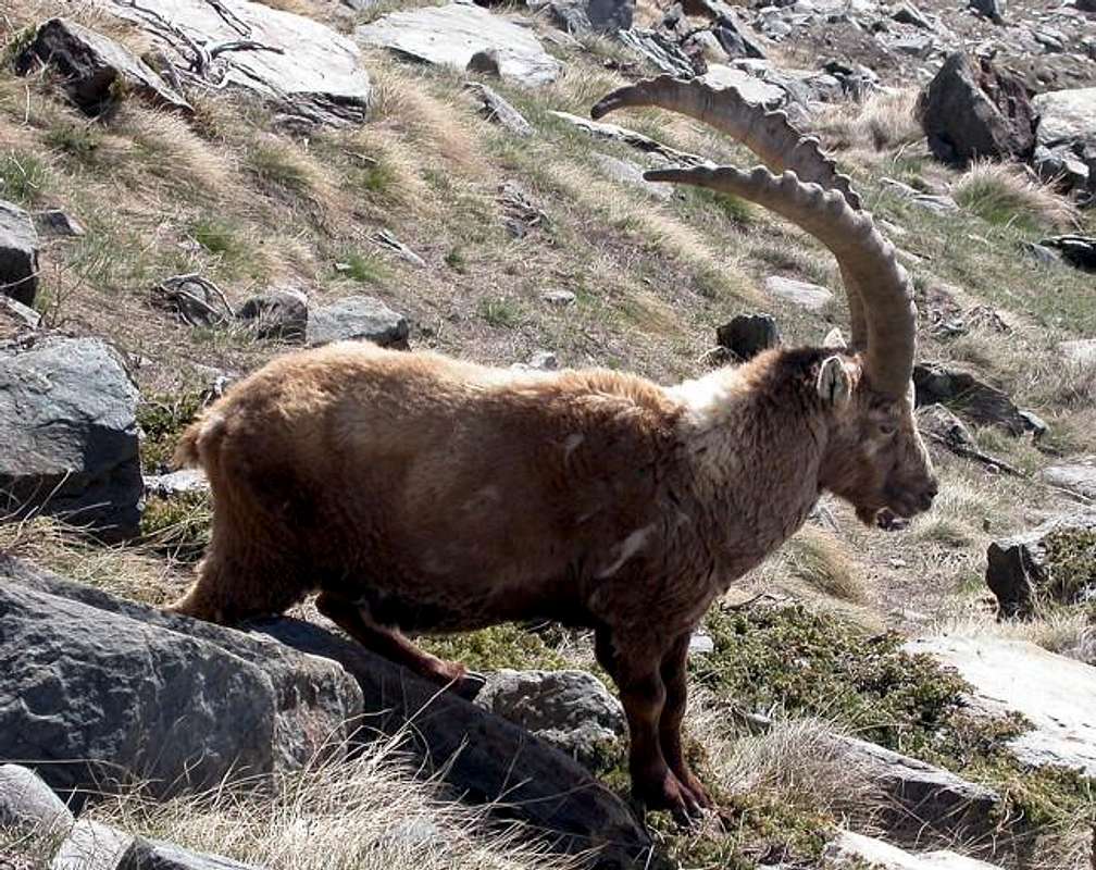
![]() "Royal Steinbock",
"Royal Steinbock",
by Antonio
Anzi quella seconda volta, scendendo dalla Tersiva, avevam anche preso la multa perché non dotati del permesso di transito. Il
"guardiaparco", che scortava due "Api Fiaggio" stracolme di stambecchi uccisi dai bracconieri, ci comminava una pesante sanzione. A noi che lì andavam per salir montagne e fotografare animali e fiori. M'arrabbiai non poco e lo minacciai di denunzia il giorno appresso presso la Procura della Repubblica per connivenza e protezione dei medesimi. Divenne bianco in volto come un lenzuolo e tacque. "Crevassino", ch'era il proprietario della nostra auto e quindi pagava lui la multa si dimostrò più malleabile, mediò e pagò la medesima. Contento lui ... Queste strade poderali che vengon costruite coi soldi di tutti noi contribuenti e poi vi metton cartello di divieto di transito, salvo eccezioni! Perché non pagano la costruzione delle stesse i proprietari? Poi mettan pur anche na sbarra con tanto di lucchetto. Ma così no! Invece proteggiamo i bracconieri che uccidon poveri animali (dal cassone e sotto i teloni uscivan le teste penzolanti con le regali corna, tanti ve n'erano), solo perché oltrepassando il Torrente Urtier sono al di fuori del Parco Nazionale del Gran Paradiso. Ma, si sà, la caccia allo stambecco é proibita comunque ed ovunque. Sto Urtier m'era sempre più antipatico, anche perché il percorrer lo stesso partendo a piedi da Lillaz é già una bella e lunghissima sfaticata.
Non avevo più voglia lì tornare.
Invece tornerò altre decine di volte. Per andare alla Punta Tersiva, ma anche per salire queste sconsolate cime che costituiscono il circondario. Mediamente sono intorno ai
3100 metri, non han linee eccelse e neppur pareti vertiginose. Però, nella loro solitudine, possiedono un fascino: quello delle cose genuine ed incontaminate. La loro conoscenza si rivolge principalmente a quattro aspetti:
1)- la classica salita della Tersiva da Cogne,
2)- la tradizionale traversata nella Valle di Champorcher tramite la Fenêtre (oggi ritornata in auge con la costruzione del Rifugio
"Sogno di Berdzé" che permette il collegamento con quello del Miserin e famoso Santuario presso l'omonimo lago),
3)- gli antichi passaggi tramite i Colli di Acque Rosse, Arietta e Bocchetta della Scaletta per il trasporto del minerale ferroso verso il Piemonte e per la famosa ed antica Processione di San Besso,
4)- la visita agli splendidi Laghi del Miserino.
"From Invergneux or Hevergnes Hill towards the Southern Urtier Valloon",
by emilius
Ma per le Sommità? Nulla o poco più. Dobbiamo attendere Georges Yeld che in
"The Mountains of Cogne (Climbers Guide)", Londra 1893 ed in
"Scrambles in the Eastern Graians 1878-1897", Londra 1900, Edizioni sempre da parte di Fisher-Unwin, ci dia dei ragguagli, principalmente con la prima ascensione della Cresta Nordovest della Punta Nera del Miserino. Tra questi due libri troviamo la fondamentale
"Guida delle Alpi Occidentali Alpi Graie e Pennine" ad opera di Giovanni Bobba e Luigi Vaccarone, Edit. C.A.I. Sezione di Torino, 25 Maggio 1896 in Torino, dove alle pagine 36/9 troviamo trattati i Colli
"Ponton, Pontonnet, Fenetre de Champorcher, Bassa di Peratza, Balma, Arietta o detto della Nouva, Miserin, Bocchetta della Scaletta e del Rancio e Colle di Eaux Rouges". Gli stessi per le Sommità ci inviano alle pagine 68/9 con
"Torre Ponton, Becco Costazza, Roccie della Balma, Testa della Nouva, Punta del Rancio e Touret di Lavina, Punta Nera, Punta Acquarossa, Punta Lavina". Qualcosa lo riscontriam ancora in
"Gran Paradiso Parco Nazionale" di Emanuele Andreis, Renato Chabod e Mario Carlo Santi, Edit. C.A.I./T.C.I. 1938, 1963 e 1980 dove alle pagine 542/8 troviamo ragguagli sul tratto di cresta che dalla Torre di Lavina raggiunge il Colle dell'Arietta. Ma questa Guida si esaurisce qui senza trattare l'alta testata dell'Urtier e dobbiamo attendere, salvo pubblicazioni locali, la
"Guida Emilius Rosa dei Banchi Parco del M.Avic" di Giulio Berutto e Lino Fornelli, medesimo Editore Marzo 2005, per avere più precise descrizioni di quest'area. Dalle pagine 164/71 abbiamo un primo dettagliato excursus che dalla Torre Pontonnet raggiunge il Colle dell'Arietta, trattando Torre Ponton, Bec Costazza, Cima di Peradzà e Testa della Nouva. Ma della Torre Ponton cosa ci raccontano i nostri Autori? Poco o nulla. B & V la liquidano in otto righe partendo da Cogne e Champorcher facendo però notare:
"Aspra e difficile sarebbe invece l'ascensione del versante meridionale, tagliato in più d'un punto a picco." In
"Emilius etc" di Berutto/Fornelli vengono riassunte sinteticamente quattro vie (Costolone N-NW o Via Normale, Cresta S-SE, Versante Sud e Costolone W-NW), appoggiandosi alla
"RM" del C.A.I. o per informazioni private ricevute. Basandoci sulle molteplici esperienze fatte in merito a questa Sommità andiamo un poco ad esplorare meglio la medesima, magari scoprendovi qualcosa d'interessante; sicuramente il Tempo ha cambiato le mie opinioni rispetto a questo vallone non visibile da Cogne, ove appar solamente la Punta Nera. Ma se sol sali a Gimillan lo vedi aprirsi ad Oriente oltre il Gruppo dell'Arolla e la Lavina, mentre dall'Invergneux lo
"controlli" e dal Penne Blanche o dalla Tersiva, meglio, lo domini.
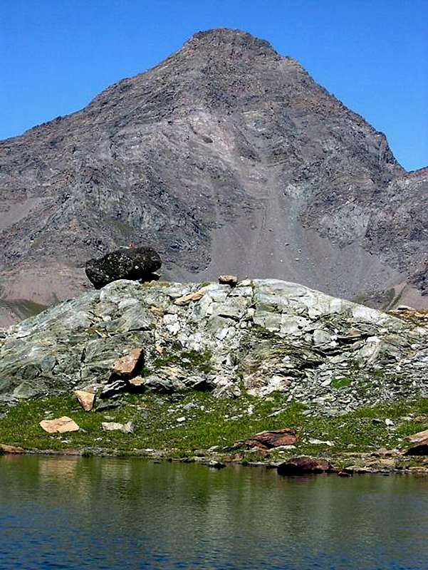
![]() "Ponton Tower from SW over Ponton Alp & Loch",
"Ponton Tower from SW over Ponton Alp & Loch",
by Antonio
But how many times have you been into Urtier Walloon and Ponton Tower?
![]() "Going to Ponton Tower, but if your way is not certain, better consult some. 2007",
"Going to Ponton Tower, but if your way is not certain, better consult some. 2007",
by emilius
But later in life, fortunately, the bad things are forgotten, leaving space for new hopes; July 19th, 1992 so I returned alone to make this crossing of West East Penne Blanche
(3205m, 3248m) starting from Gimillan and first going up to Mount Creya
(3015m). Looking up from the Walloon of the Urtier, but looking good in that down there. From the Pas d'Invergneux
(2902m) down the Alp Ervillères
(2515m) and then to Grauson, whence again Gimillan
(1787m). I only
"touched" the Urtier.
But the murderess always returns to the scene of the crime: July 18th, 1993 I go, with my son Alessandro, seventeen, to the Punta Nera Miserino's
(3064m) through the shattered Southeast Wall and just a month later with a group of friends return to Tersiva
(3514m); on these occasions the
"keepers pain in the ass" and there is no and in October 16th, 1994 with the "Peppino" and still Alessandro, I go up into the Urtier to Alp Broillà or, rather, Broillot
(2399m), under the Punta Nera and climb safely to the two beautiful Miserino's Lakes
(2664, 5m), discarding the left (East) the route to the Arietta Pass
(2947m). On this wonderful day of Autumn, with the fresh air already heralding the winter, climb the steep stony slope Westward reaching a notch with the great bell tower, which is also seen from Cogne
(1531m). Now that we are on the Via Yield, with the Valtournanche Guides Beniamino and Anselmo Pession, the Broillot covered in full by 12th August 1912. We climb only this last part facing North and on the Summit awaits the colorful tiny rooster that seems to send his
"chicchiricchi" in the direction of Cogne. We go down to the South Ridge and with a delicate traverse beneath the Punta della Scaletta, due to the ice, we reach the Miserino Hill
(2842m), whence the lakes. Lovely days that reconcile me with this walloon. They spend five years and 14th August 1999 I go with a group of friends by Bari to Fenêtre de Champorcher
(2826m), but starting from the Dondena Champorcher Valley. Powerful air currents push the clouds in spiral with fantastic designs well above this large window; definitely avoid watching out on Urtier extremely cold and wind we take shelter in the cabin unsafe, despite the warnings of prohibition, just below the South Crest and Southeast Face, that steep climb to the Ante Top
3042 metres.
Above stands the Tour Ponton, who appears here, among the sudden glimpses of clouds, like really big tower.
I have to go pick up the same. Four days later return with Gianfranco Vicentini and Nicola Colajanni do it again the Punta Nera going up for a corner, however, more to the left (North-northeast) and descending the North Ridge.
From the top I take a look at the Tower, down below. Where do you go (then there was only the B & V and the crest of the Fenêtre seemed to be discarded)? On September 02th, I go with Emilio. Climb to the
"Baita Hunters Orlando" at the Alp Ponton
(2631m), just above the eponymous lake. Here we can expect a surprise: a cow is lying on the lawn. Dead and with a swollen belly (the return Ducly owners, by Pollein Municipality, will tell you, how to visit the Vet, due to the bite of a viper in the head). We continue Eastward with a small path that leads to Fenêtre but reached a spring in altitude
2673 metres abandon him and begin to climb a steep stony against the vertical Wall West, and when this bar us the way, just bend to the left and go up to a increasingly steep and narrow gorge that ends at a notch in
around 2840/5 metres immediately upstream of the last pylon
"Superphoenix". A delicate climb on broken rocks, and brittle in the last part suddenly bathed in a little brook of water leads us on the ridge. Here see the little path that goes around with hemi circular moving from Pontonnet Lake
(2808m); we would have to take this, certainly more comfortable, from the
"Baita Orlando".
![]() "Climbing integrally in edge of W-NW Rib, 2002",
"Climbing integrally in edge of W-NW Rib, 2002",
by emilius
We get an Edge-Rib West-northwest that, with fun and quite easy climbing carried out on the ridge, leads us to an Ante Top and then to the cairn of the Summit.
Finally we reached this Tour Ponton! Go down the easy North-northwest Crest to the Pontonnet Hill
(2897m) and from this to that near Fénis
(2857m), even with this crumbling shack before rising to Pontonnet and return with the tour had to be done in the morning climb.
But how many times have you been into Urtier Walloon and Ponton Tower?
![]() "Let's towers here, towers there. But where is this Ponton Tower?",
"Let's towers here, towers there. But where is this Ponton Tower?",
by emilius
Many, perhaps more than thirty or less than forty, going at different times, by different routes and repeatedly near Bec Costazza
(3092m), the next Summit of Péradza with the adjacent Rocce Nere of Péradza
(3021m, 2991m), Tête de la Nouva
(2963m), Tête de l'Arietta
(2988m), Punta Miserino
(3010m) and again in the Punta Nera, with Emilio July 06th, 2000 twice in one day. And beyond Torrent Urtier Penne Blanche, Pointe Coupée
(3211m), Tête de Money
(3130m) and Punta Tersiva , true Lady of this Realm.
And do not you ever get tired of the Tour Ponton and the Urtier? No, in fact I would go there more and more I enjoyed it. Maybe wandering around with snowshoes to discover a new Urtier, candid and still more pristine until the
"Dream of Berdzé" under the Fenêtre, in a striking and almost surreal.
I became the true "Owner of the Valley ..."
![]() "Tersiva viewed from Miserino Lochs into Urtier",
"Tersiva viewed from Miserino Lochs into Urtier",
by livioz
Ma poi nella vita, per fortuna, le cose brutte si dimenticano lasciando spazio a nuove speranze; così il 19 Luglio 1992 son tornato da solo a far sta traversata dei Penne Blanche partendo da Gimillan e salendo dapprima al Monte Creya
(3015 m). Guardando dall'alto il Vallone dell'Urtier, ma guardandomi ben dal fatto di scendervi. Dal Pas d'Invergneux giù all'Alpe d'Ervillères e poi al Grauson, donde nuovamente a Gimillan. Avevo soltanto
"sfiorato" l'Urtier. Ma
l'assassino torna sempre sul luogo del delitto: il 18 Luglio 1993 vado con mio figlio Alessandro, diciassettene, alla Punta Nera del Miserino
(3064 m) per la frantumata Parete Sudest e giusto un mese dopo con un gruppo di amici ritorno alla Tersiva; in queste occasioni il
"guardiaparco rompiballe" non c'é ed il 16 Ottobre 1994 col "Peppino" ed ancora Alessandro risaliamo l'Urtier fino all'Alpe del Broillà o, meglio, Broillot
(2399 m), sotto la Punta Nera e saliamo tranquillamente ai due splendidi Laghi del Miserino
(2665 m), scartando a sinistra (Est) la via per il Colle dell'Arietta
(2947 m). In questa splendida giornata d'Autunno, con l'aria già fresca che preannuncia quella invernale, saliamo la ripida pietrraia verso Ovest raggiungendo un intaglio con il grande campanile, che si vede anche da Cogne. Adesso siamo sulla Via Yeld che, con le Guide di Valtournanche Beniamino ed Anselmo Pession, la percorse integralmente dal Broillot il 12 Agosto 1912. Noi saliamo solo quest'ultima parte rivolta a Nord e sulla Sommità ci attende il galletto colorato che sembra mandare il suo
"chicchiricchi" in direzione di Cogne. Scendiamo per la Cresta Sud e con una delicata traversata sotto la Punta della Scaletta, causa il ghiaccio, raggiungiamo il Colle Miserino
(2842 m), donde ai laghi. Belle gite che mi riconciliano con questo vallone. Passano cinque anni ed il 14 Agosto 1999 vado con un gruppo di amici di Bari alla Fenetre de Champorcher
(2826 m), ma partendo da Dondena nella Valle di Champorcher. Potenti correnti d'aria spingono le nuvole con disegni fantastici a spirale molto sopra sta grande finestra; ci guardiam ben d'affacciarci sull'Urtier e per il vento oltremodo freddo ci ripariamo nella baracca pericolante, nonostante gli avvisi di divieto, appena al di sotto della Cresta Sud e della Parete Sudest, che ripida sale alla Antecima
3042 metri.
Sopra troneggia la Tour Ponton, che da qui appar, tra gli squarci improvvisi della nuvolaglia, veramente come gran torre.
Debbo andar salirla. Quattro giorni dopo ritorno con Gianfranco Vicentini e Nicola Colajanni a far nuovamente la Punta Nera salendo però per uno spigolo più a sinistra (Nord-nordest) e scendendo per la Cresta Nord.
Dalla Cima butto un'occhiata alla Tour, laggiù in fondo. Dove si passa (allora c'era solo la B & V e la cresta dalla Fenêtre mi sembrava da scartare)? Il 2 Settembre vado con Emilio. Saliamo alla
"Baita dei Cacciatori Orlando" presso l'Alpe Ponton
(2631 m), appena sopra l'omonimo lago. Qui ci attende una sorpresa: una mucca è distesa sul prato. Morta e con il ventre gonfio (al ritorno i proprietari Ducly di Pollein ci diranno, come da visita del Veterinario, causa il morso sulla testa d'una vipera). Continuiamo verso Est con un sentierino che porta alla Fenêtre ma, raggiunta una sorgentina in quota
2673 metri l'abbandoniamo ed iniziam salire una ripida pietraia contro la verticale Parete Ovest; quando questa ci sbarra passaggio, pieghiamo appena a sinistra salendo per una gola sempre più ripida e stretta che termina ad un intaglio a
2840/5 metri circa subito a monte dell'ultimo pilone del
Superphoenix. Un'arrampicata delicata su rocce rotte, friabili e nell'ultimo tratto bagnate da un rivoletto d'acqua ci porta sul crinale.
![]() "The better Route from Hunters Baita Orlando" 2005,
"The better Route from Hunters Baita Orlando" 2005,
by emilius
Qui vediamo il sentierino che sale con giro semicircolare passando dal Lago Pontonnet
(2808 m); avremmo dovuto prender questo, certamente più comodo, dalla
"Baita Orlando". Saliamo uno Spigolo/Costolone Ovest-nordovest che, con divertente ed abbastanza facile arrampicata effettuata sul fil di cresta, ci conduce ad un Antecima e poi all'ometto in pietra della Sommità.
Finalmente abbiamo raggiunto sta Tour Ponton! Scendiamo per la facile Cresta Nord-nordovest al Colle Pontonnet
(2897 m) e da questo a quello viciniore di Fénis
(2857 m), anche questo con baracca pericolante per poi risalire al Pontonnet e rientrare col giro che andava fatto la mattina in salita.
Ma quante volte sei andato nel Vallone dell'Urtier ed alla Tour Ponton? Molte, forse un pò più di trenta o poco men d'una quarantina, salendo in tempi diversi, tramite differenti vie e ripetutamente il vicino Bec Costazza
(3092 m), le successive Cima di Peradzà con le attigue Rocce Nere di Peradzà
(3021 m, 2991 m), Tête de la Nouva
(2963 m), Testa dell'Arietta
(2988 m), Punta del Miserino
(3010 m) ed ancor Punta Nera, con Emilio il 6 di Luglio del 2000 due volte in giornata. E al di là del Torrent Urtier i Penne Blanche, Pointe Coupéé, Testa di Money e Tersiva
(3514 m), Signora di questo Reame.
E non ti sei mai stancato della Tour Ponton e di sto Urtier? No, anzi più v'andavo e più mi divertivo. Magari girovagando con racchette da neve per scoprir un Urtier nuovo, candido, maggiormente incontaminato fino al
"Sogno di Berdzé" sotto la Finestra, in ambiente suggestivo, quasi del tutto surreale.
Ero diventato il vero "Proprietario della Valle ..."
"To discover a New Urtier, candid and still more pristine to the "Dream of Berdzé", below Champorcher Fenêtre & Ponton Tower ...",
by emilius
Comments
No comments posted yet.