
-
 8803 Hits
-
 85.36% Score
-
 20 Votes
|
|
Mountain/Rock |
|---|---|
|
|
28.31362°N / 16.60002°W |
|
|
Hiking |
|
|
Spring, Summer, Fall, Winter |
|
|
7083 ft / 2159 m |
|
|
Overview
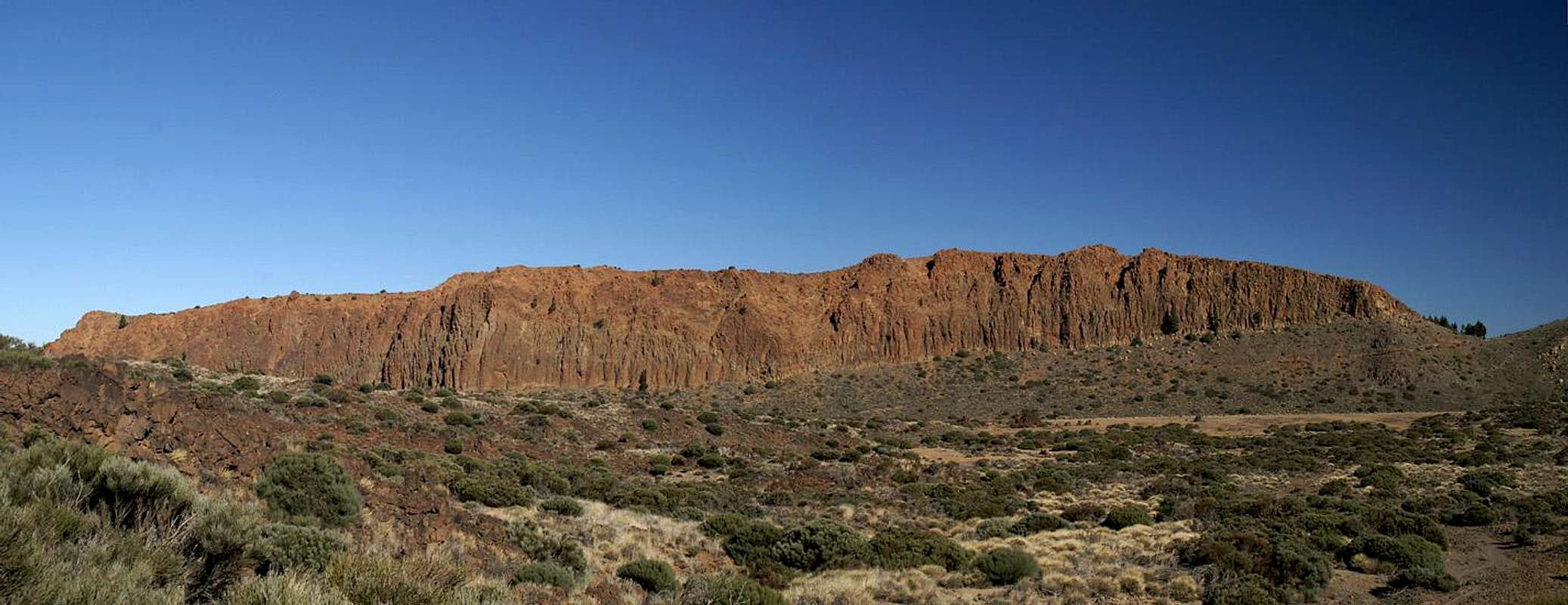
 Riscos de la Fortaleza above Cañada de los Guancheros Riscos de la Fortaleza above Cañada de los Guancheros |
Las Cañadas del Teide - the canyons of Teide in my loose translation - are the areas which surround Spains highest mountain on its western, southern and eastern sides. They are the interior of a giant caldera, the largest volcanic crater on earth with a diameter of 17km (more than 10 miles) and 48km (30miles+) circumference. These "canyons" have been filled with lava flows emanating from El Teide and rather resemble plains when seen from above and afar. In reality they are a labyrinth of lava almost impossible to penetrate. Of the caldera walls today less than two thirds are left standing. The whole northern part has either been buried by the buildup of Teide itself or swept down by huge landslides towards the north coast of Tenerife. Currently it is believed that these landslides actually created the caldera but older theories speak of the collapse of a giant volcanic cone some 170000 years ago.
The only remainder of the leftover caldera walls on the north side of the crater is called La Fortaleza - or rhater Riscos de la Fortaleza, the "rocks of the fortress". The name already indicates that the mountain is one large bastion of rock, quite in contrary to the other caldera rim mountains. In general erosion has done away with much of the caldera wall, forming profound saddles, hunchbacked mountains, summit plateaus or rather bizarre rock structures. Here at La Fortalezza the original aspect can still be seen - a long vertical wall made of red basalt.
Of course erosion has taken its toll here too - the rock quality is rather low if you apply general standards - if you apply Cañadas ones the rock fares much better. The southern walls are formed by basaltic blocks which are rather solid but which often are placed among loose debris. Climbing the south face is out of the question anyway since within the natural park leaving the trails is not tolerated in any way.
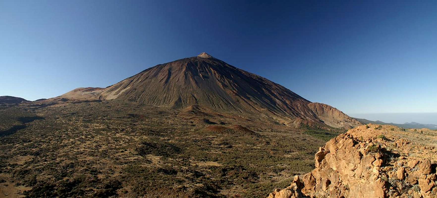
The mountain therefore is climbed from the outward side, where like for all of the caldera mountains, the slopes are rather shallow. The hike from the National Park visitor centre to La Fortaleza doesn't take more than 90 minutes if you hike slowly and therefore is quite popular among the hiking crowd. La Fortaleza, though rather low in elevation, commands good views of Teide, Montaña Blanca, the Cumbre Dorsal Range and the north coast of Tenerife. The real attraction, however, is neither mountain nor view. La Fortaleza is located at the southern tip of large triangle of hiking trails which connect it with the visitor centre and Montaña Blanca, one of the great tours on the island. It runs through a desert like scenery, where gorse bushes are the only vegetation. There are stark colour contrasts between the yellow and orange pumice gravel, the red rocks, bblack lava and blue sky.
|


Views from the top
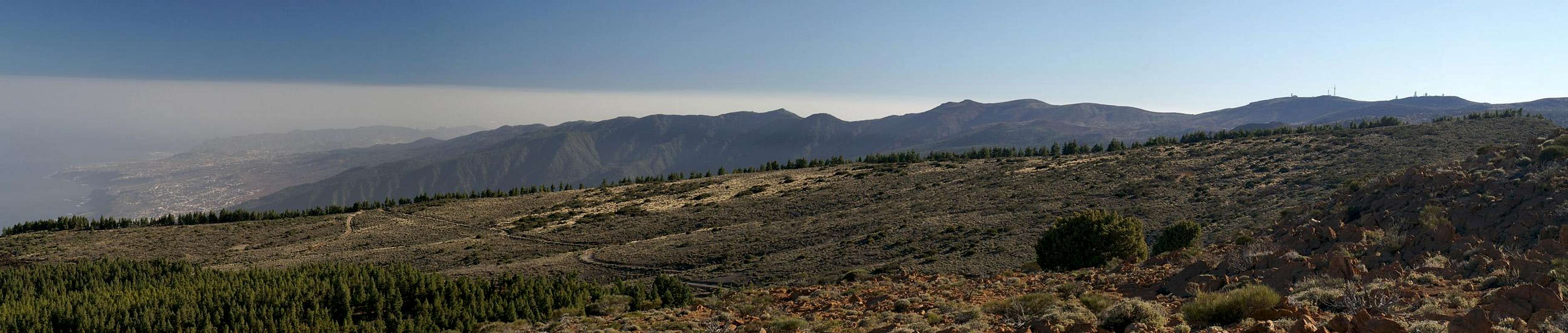  |
Naturally the best views from La Fortaleza are towards Teide, especially since the northern view of Spain's highest mountain is not as well known as the eastern and southern ones. On the other hand the whole long range of the Cumbre Dorsal can be seen in the east, as well as the coast and the north-eastern tip of the island, the Anaga peninsula. Beyond the islaand boundaries you can see La Palma to the north-west, the first glimpse I caught of that island during my stay on Tenerife.
|


Getting There
 |
As one of the major European vacation getaways Tenerife can be reached from all major European airports. From Spain there are regular flights from the rest of Europe you can book lots of charter flights. On Tenerife there are two international airports, one at Santa Cruz in the east, one at Los Abrigos in the south.
You can reach the Cañadas del Teide from all four directions. Just drive as far upwards as you can and you'll be there. From the south there is a road from the airport via Villaflor to the Cañadas, from the West you must head for Chio either from Playa de las Americas or from Santiago del Teide. The northern road starts from Puerto de la Cruz and the eastern ascent starts from the capital Santa Cruz del Tenerife and crosses the mountain range Cumbre Dorsal.
Alternatively you can take the bus either from Playa de las Americas (Line 342) or from Puerto de la Cruz (Line 348). Both buses depart at about 9:00 a.m., the return buses go around 4:00 p.m.
The trailhead for La Fortaleza is at El Portillo at the visitor centre. A 1h hike takes you to Cañada de los Guancheros, from where two trails lead up to Degollada del Cedro to the east of the summit. The remainder is a short scramble along the basalt rocks.
Red Tape
 |
As mentioned in the overview La Fortalezza is part of the "Parque Nacional del Teide" which is composed of a giant volcanic crater the "Cañadas del Teide" with 48km circumference. As part of the old Caldera wall La Fortaleza is located at the north-eastern edge of the park but on the outside the natural park "Corona Forestal" surrounds it.
Activities in the national park are limited as in every park. You are requested not to leave the trails - and from your own judgement - you shouldn't. The lava sometimes piles up to great heights and makes orientation VERY difficult. Also, the part near La Fortaleza is rather flat and desert-like. Gorse bushes restrict your view and once off the trail you can be easily lost. We witnessed a helicopter search from the top of La Fortaleza but it is very difficult even for the pilots to see anything among the brushwork and rocks.
There are few but very beautiful flowers in the park. Please leave them in their place - some of them only blossom for a few hours each year. The whole park is VERY dry so any flora is severely limited.
Accommodation
Of course you can find a lot of hotels, fincas and casas on the island which you can book from any travel office. The Cañadas del Teide are a natural park so there is no camping allowed. You might use the Parador Hotel which is supposed to be quite expensive, however. Better stay at one of the hotels at sea level and drive up by rental car or bus.Weather Conditions
There are several sites on the web which give you information on the weather on Tenerife. However, they all show the weather for the coastal regions (Puerto de la Cruz) which significantly differs from the weather in the Cañadas del Teide which are 2000m of elevation higher. The following table shows data for Puerto de la Cruz on the coast.| Month | Jan | Feb | Mar | Apr | May | Jun | Jul | Aug | Sep | Oct | Nov | Dec |
| Avg. day temp.[°C / °F] | 19 / 66 | 19 / 66 | 20 / 68 | 21 / 70 | 22 / 72 | 23 / 73 | 24 / 75 | 26 / 79 | 26 / 79 | 24 / 75 | 22 / 72 | 20 / 68 |
| Avg. night temp.[°C / °F] | 13 / 55 | 13 / 55 | 14 / 57 | 14 / 57 | 16 / 61 | 18 / 64 | 19 / 66 | 20 / 68 | 20 / 68 | 18 / 64 | 17 / 63 | 14 / 57 |
| Water temp.[°C / °F] | 19 / 66 | 19 / 66 | 19 / 66 | 19 / 66 | 20 / 68 | 20 / 68 | 22 / 72 | 23 / 73 | 22 / 72 | 22 / 72 | 21 / 70 | 20 / 68 |
| Rainy days | 10 | 7 | 8 | 4 | 3 | 2 | 1 | 1 | 3 | 5 | 7 | 9 |
The Canarian Islands (as well as Madeira) are located in the trade wind zone. You almost always encounter northeastern winds which carry a lot of humid air. Being forced to climb to higher altitudes this moisture condenses into clouds. This in return means that most of the time the northeastern part of the islands is covered in clouds from altitudes of 1000m through 2000m.
The mountains themselves - being mostly of the same altitude - finally stop the clouds so that on their southeastern slopes the clouds "run out". In the case of Tenerife the Cañadas del Teide are so high that rarely ever you encounter fog or clouds. This on the other hand means that the whole area is very dry so be sure to bring your own water.
Maps & Books
Out of the multitude of maps and books I have been using the following. However, so far I have not found a good hiking map of the island. The one posted here is ok but shows only a fraction of the marked hiking trails. The guidebook is excellent but be careful if you do any one of the suggested "variations" to the tours described therein. The variations are described in a few words only and you might get the wrong impression of their quality.- Maps
- Teneriffa
Kompass Map WK233
Kompass Verlag
ISBN: 3-85491-038-X
Books
- Teneriffa, Tenerife
K.Wolfsperger, C. Ade
Rother Walking Guide
Rother Verlag
English - ISBN: 3-7633-4809-3
German - ISBN: 3-7633-4016-5