
|
|
Route |
|---|---|
|
|
36.65610°N / 118.3103°W |
|
|
Mixed Snow and Rock |
|
|
Most of a day |
|
|
Class 2 |
|
|
Getting to the Trailhead
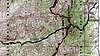
When leaving 395 on the dirt road, zero out the odometer. Follow the road around the curve, past the graveyard, and past the first dirt road on the right at 1.9 mile. Continue to mile 2.5, THEN take a dirt road to the right.The drive to the trailhead will take 35 to 40 minutes from 395 in a high-clearance 4 wheel drive.
Most people discourage the use of low-clearance vehicles beyond the Manzanar graveyard. Low-clearance cars can expect to spend 90 minutes gingerly working their way up the road.
The dirt road ends abruptly in an oak grove at George Creek. There's a parking spot (a patch of brush-less dirt with room for 2 vehicles) less than 100 yards from road's end, this is the 4WD parking lot. There's also the 2WD parking lot (a patch of dirt with room for 3 vehicles) about 1/2 a mile short of this.
Approach
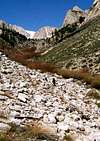
When you start up George Creek from the trailhead, you will have to take it on faith that there is a trail. It looks hopeless from the outset. However, do not be tempted to climb anything or cross to the south side of the creek. Proceed upstream favoring the north side. After about 300 feet of moderate bushwhacking, a well-used and obvious trail will gradually appear. Follow this trail (well marked with trail ducks) until the canyon narrows considerably, you reach a bend, and further obvious progress is blocked. Here, cross over to the south side of the creek and pick up a new trail. Follow this trail until you reach a waterfall in a stand of pines where progress is again blocked. Cross over to the north side to pass the obstacle and then return to the south side as soon as possible. Depending on conditions, it may be necessary to cross to the north side and back again one more time when the stream brushes up against the south wall of the canyon. After the last jump to the south side, stay there following the faint trail fairly high on the slope above the creek. This trail will cross the south fork of George Creek in a stand of pines. From there, head north and then west on to the broad plateau. Cross George Creek for the last time at a very large (12-15' high) solitary blocky boulder with black stains. Work your way up the creek to good campsites at 10,000' or 11,200'.There is no rock-climbing required on this approach. If you have to climb any cliffs, you are not on the right trail. You are lost and should back up. Avoid brush and the stands of Aspens.
 |  |  |  |  |
Route Description
From the trees at about 11,200’ on the upper reaches of the north fork of George Creek, ascend the southeast ridge of Williamson. There are two prominent towers or “thumbs” near the top of this 1,900’ high ridge, a smaller thumb to the west, and a bigger one to the east. Climb the ridge aiming between the two thumbs. If you are lucky, there will be snow covering the talus and scree. Do not climb the chute to the east, as it is steeper and full of loose junk. The chutes and ribs to the west are also much harder. Once on top of the ridge, follow it west towards the summit mass and the 1,000' east face. There are two obvious routes up the east face: 1) ascending the middle of the broad slope, or 2) climbing the chute to the left of the slope. Once you get to the summit plateau, climb 300' over talus to the summit. | 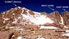 |  |  |  |
justinjohnsen - May 6, 2008 4:05 pm - Hasn't voted
Reaching the trailheadThe attached topo map image of the drive in from Manzanar is a perfect guide. When leaving 395 on the dirt road, zero out the odometer. Follow the road around the curve, past the graveyard, and past the first dirt road on the right at 1.9 mile. Continue to mile 2.5, THEN take a dirt road to the right. The drive to the trailhead took us 35 to 40 minutes from 395 in a high-clearance 4 wheel drive. I don't recommend low-clearance vehicles beyond the Manzanar graveyard. We took *twice as long* escorting two very low-clearance cars. The trailhead isn't a trailhead per se. The dirt road just ends abruptly in an oak grove at George Creek. There's a parking spot (patch of bushless dirt with room for 2 vehicles) less than 100 yards from road's end, this is the 4WD parking lot. There's also the "2WD parking lot" (patch of dirt with room for 3 vehicles) about 1/2 a mile short of this.
phomchick - Sep 2, 2015 7:35 pm - Hasn't voted
Re: Reaching the trailheadThank you for the description of the drive to the trail head. I've added your material to the page.
justinjohnsen - May 6, 2008 4:07 pm - Hasn't voted
Google Map with George Creek route notesI collected some waypoints and route-finding hints on a public Google Map. Feel free to use it if it helps you plan the trip, or add your own notes for posterity.