
-
 23978 Hits
-
 72.71% Score
-
 3 Votes
|
|
Route |
|---|---|
|
|
37.27060°N / 118.6728°W |
|
|
rock climbing |
|
|
Half a day |
|
|
III, 5.4 |
|
|
Approach
From the town of Bishop on Hwy 395, head west on scenic Hwy. 168. After approximately 10 miles, turn right on Dutch Johns Meadow road ( behind the old drive thru wilderness information kiosk ) and follow this rough road ( 4 x 4 or high clearance vehicle recomended ) for about 6.2 miles. You are passing thru the beautiful Buttermilk Country! Go left at a fork then head up to the McGee Creek trailhead ( 4 x 4 needed for the last part ). Cross country hike south to the South Fork of McGee Creek and follow this upstream ( west ) to a barren camp below the huge moraine below the Southeast Face of Mount Humphreys.
Route Description
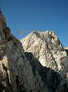
This excellent climb begins by trudging up sand slopes that lead up a gully that is right of the Southeast face and the pocket glacier at its base. Before reaching the notch in the East Arete staight up the gully, follow a sandy gully that heads left to a notch higher up on the ridge. One can look down on the glacier from this point. Class 3 and 4 climbing leads up to a vertical step. Improbable 5th class moves lead around the left side to a good ledge. A pitch of 5.2 up cracks leads to a ridgetop. follow the ridge line and turn a big rock on the left, then follow the ridge to the plateau below the summit cone. 5.4 climbing uo the face from the right hand side leads up and left to easier ground and the summit. Down climb and rappel the route.
The East Arete can also be climbed from the glacier on the north side, but i have no first hand knowledge of this variation.
this climb is one of the " 100 Classic Climbs of the High Sierra ", and deservedly so!
 |
Essential Gear
A rope, and a light rack plus a few slings are all most climbers will need. Early season ice axes may be needed in the sandy gully.
Miscellaneous Info
If you have information about this route that doesn't pertain to any of the other sections, please add it here.
Jack Daniels - Aug 24, 2003 11:28 am - Hasn't voted
Route CommentIt isn't difficult to get within 1 mile of the trailhead without a 4x4 or even a high clearance vehicle if you go by way of the Buttermilk Rd. A Toyota Corolla would do. The last 1 mile is steeper and most people park at the base of the first steep hill as there are good pullouts and nice, creekside camping. Refer to Peter Croft's book for a description of the Buttermilk Rd. approach.
Jack Daniels - Aug 24, 2003 11:35 am - Hasn't voted
Route CommentThe East Arete as originally soloed by Norman Clyde begins in the notch above the glacier as described here. However it is also possible to begin the ridge at a saddle east of peak 12,241. The ridge leading to the notch includes some wonderful class 3 and 4 scrambling, goes over (or around) a subpeak (13,000+), and then drops into the notch. There is some interesting downclimbing into this notch. Be prepared for a little 5.8/5.9 downbouldering, some very circuitous downclimbing, or else a short rappel. After the notch is reached, you're back on the standard route.
Peter Croft writes: "Clyde soloed the route in the summer of '35, another feather in his cap. However, on his ascent he missed out on the long initial ridge that makes this route so good. Nowadays, if you want full bragging rights you have to do the whole thing."
Donno - Jun 18, 2015 9:56 pm - Hasn't voted
Re: Route CommentJack, I believe you mean the complete route starts "southwest" of peak 12,241, not "east".
Donno - Aug 12, 2015 12:47 am - Hasn't voted
Route CommentA Toyota Corrolla will NOT make it up Buttermilk Rd to the camp spot. You need a high clearance vehicle.
Craig Peer - Dec 19, 2015 4:26 pm - Hasn't voted
Re: Route CommentThose roads change over the years. One big hard wet year can make for one muddy mess of a road !