
|
|
Route |
|---|---|
|
|
3.0667°S / 37.35000°E |
|
|
Hike |
|
|
A few days |
|
|
Walk-up |
|
|
Approach
Start from the Marangu Gate of Kilimanjaro National Park. You can sleep the previous night at any one of the hotels at Marangu Village (different qualities) or at Moshi (some 40 kilometers away by road).Route Description
 Marangu gate
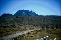
Begin walking at Marangu Gate, by the obvious route starting through the rain forest. It is a wide road for the first hour and a half -or so-, and afterwards narrows to become a path winding through lower forest in search of the small "village" of Mandara Hut (named after an ancient local tribal chieftain). There is an alternative route, clearly visible on your left hand shortly after leaving Marangu Gate. This narrower path will take you to the very same place but provides a wilder aspect of the rain forest, being designed to allow closer views of plants and -if lucky- animals. This narrow (western) path joins the main track in two different points, after approximately one and two hours walking.
SIDEWALK for the first afternoon: MAUNDI CRATER.
This is a small old crater of the huge volcano formed by Kibo, Mawenzi and Shira. It stands about half an hour east of Mandara Hut. Personally, I expected something more exciting for it's only a big hole covered by grass and some trees, but it can offer some nice views east of Kili, over the huge Tanzanian Plains. If the weather is clear enough, you might also catch a glimpse of Mawenzi and (much smaller) Kibo. The whole track to Maundi Crater and back is well indicated by signposts.
 |
 |
 |
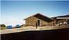
 Horombo hut
The day begins walking east, through a giant forest. After a short time the trail passes by Maundi Crater and turns north to emerge out of the forest and into the moorland. This is where you will get your first view of Kibo. Afterwards the walk goes on to the north-west, with some small turns, in search of Horombo Hut. A long walk by a beautifully marked path with some tables and benches about midway, to make it a more comfortable lunch. After five hours walk or so, you shall get to the small moorland village called Horombo Hut.
SIDEWALK for the second afternoon: ZEBRA ROCK
Just after leaving Horombo Hut to the west, the path forks into two branches. The left (western) one shall be our way to go on to Kibo Hut. For this afternoon we take the right-side one (eastern), passing by wide areas of grassland and local vegetable species. It shall be about an hour before we make it to the four thousand meters of altitude, marked by some stones on the path. Shortly afterwards we shall find the Zebra Rock on our left hand side. Get back to Horombo by the same path.
 |
 |
 |
 |
 |
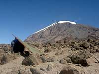
 Last Water Point
Just after leaving Horombo on your way up, you will find on your right the camping area for people coming down from the Machame or the Loitokitok Routes and shortly afterwards the path forking we saw yesterday afternoon. Though any of both branches would lead us to the Saddle and Kibo Hut, this time we take the left (western) one. It winds up a not-too-hard slope, amongst the low forest of the moorland, for about an hour or so. Afterwards you shall pass by the Last Water Point of this route and enter the huge stone desert of the Saddle.
The views are splendid over Mawenzi, and Kibo begins to overwhelm you while you look at the already obvious route to be climbed towards Gilman's Point. Plenty of time shall be available for these considerations, as the walk is an easy one and it's a wide, wide track. A five-hours walk shall place you in Kibo Hut, but do not hurry. My experience is that altitude can be easily felt from this stage onwards and acclimatization on the Marangu Route is said to be hard enough without hurrying.
An early dinner will close this day, in preparation for the summit attack.
SIDEWALK for the third afternoon: I am not aware of any suitable goal for this short afternoon at Kibo Hut. What we did was to walk for a while on the path to Gilman's Point and enjoy the golden sunset over the Saddle and Mawenzi. Any suggestions for this afternoon shall be welcome and (of course!) included in due time in this route.
 |
 |
 |
For this third day, another option would be not to sleep any higher but delay arrival to Kibo Hut for another twenty-four hours. Staying in Horombo Hut for the day is not advisable, though. If you choose this option for the sake of acclimatization some walking would be better than that. Amongst other options, you might consider going up the previous afternoon path to Zebra Rock and proceed higher until you find a forking of the path. Take the right side one to go to Mawenzi's lower slopes and Mawenzi Hut. Some exploration of this area might make for a good pastime and a nice excuse for acclimatization.
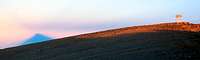
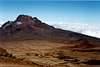
 Sunrise behind Mawenzi
The fourth day's start is an early one. Most parties leave Kibo Hut by midnight, after about six hours to rest in your sleeping bag. And most people do not really sleep up there. Much too high and too fast a climb. Never mind that, most people have a proper headache around here, but if you are feeling really sick you shouldn't attempt to go any higher but descend as fast as possible and anyway this should be the last really hard day.
Anyway: after leaving Kibo Hut you have to walk north for a short while, just enough to pass by the last small huts of the area and a rocky chaos placed behind them. A matter of five minutes before turning left (west) and beginning the climb. It's a long and dark one, just scree and stones to be seen in front of your feet at first. Slowly gaining altitude, you shall pass by the yellow signpost (in the ground in September 2001) indicating "Hans Meyer's Cave" and keep on going through a terrain becoming steeper and steeper. It's all a test for your strength of will. Keep going, be stubborn and the blue band of dawn will finally show up behind Mawenzi. About the time you reach Gilman's Point sunrise will become kind of a natural undescribable show and there will be only the final two hundred meters (or so) to climb to get to Uhuru Peak.
The bad news is that this final climb from Gilman's to the summit is still a long one. About a couple of thousand meters to be covered at almost 5900 meters. It will probably take all your physical and mental strength to reach the wooden sign of Uhuru Peak and the highest point in Africa, but it's the last push. The feeling is worth it and so are the sights.
Afterwards it will only be a matter of going back the same way and enjoying the feeling of thicker and thicker air. Be careful when descending from Gilman's Point to Kibo Hut. The scree will usually be much looser than it was on the way up, and might make for a nasty slip.
The walk from Kibo Hut back to Horombo Hut will be a glorious end for a big mountain day, with plenty of time to comment any previous happenings, and arrival to Horombo (in my experience) will close an exhausting but very special climb.
 |
 |
 |
 |
 |
 |
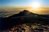
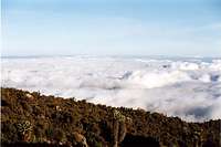 Cloud sea
Not much to be said about this last day. An early wake-up will usually be the rule, in order to have breakfast and get back to Marangu Gate rather soon. That way, you should be able to get on the minibus (or whatever transportation is provided) quite soon and be back at the hotel for a relaxing shower and an afternoon rest. All the way down shall be full of memories of the way up. Only three or four days elapsed, and it seems like four years...
Essential Gear
No need for special technical material (rope, ice axe, crampons) if you come around in the normal season. Out of this months, consider this route a high mountain one. Always bring warm clothes, as good as possible, optimal boots and sun goggles. And don't forget good gloves and winter hat, whatever the time of the year.Acclimatization
In spite of being the easiest (technically!!) route to the top uf Uhuru Peak, and known to locals as "Coca-Cola Route", Marangu Route can become kind of a trap to badly acclimatized climbers. This problem arises as a consequence of the prohibition to camp in most places of the National Park and the location of the Huts. You can't really choose where to sleep (and it's good to protect nature like this), but that means you might have to climb higher than your body can really stand. Walk as slowly as you can, you are in no hurry to reach the next hut. If you can get there in six hours, there's no need to make it in four. Every minute spent on the trail works in your favour. In short, follow the expert advice from guides and porters: "Pole Pole".
An additional advice would to try and follow the old motto "Climb high, sleep low". Do not stay in the Hut during the afternoon, go out for a walk a little higher (make it one or two hours) and come back down for dinner.