
|
|
Route |
|---|---|
|
|
39.17170°N / 105.1976°W |
|
|
Easy Scramble |
|
|
Half a day |
|
|
class 2 |
|
|
The Trailhead
 View of TB below trailhead
Nine-J Road was closed for a time following the Hayman fire, but was open again as of 2005. From the turnoff onto 9-J "Nine-J" Road, drive 1.5 miles to a sharp left bend in the road. A small parking area is marked there, which once again constitutes the Thunder Butte trailhead.
Route Description
 Summit ridge
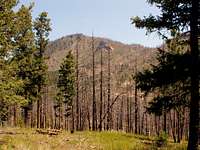 southwest slopes
 Route overview
The key to the lower part of this route is finding and staying on the ridge crest. The ridge is very gentle, but discernable. From the trailhead, walk north, the same direction as the road was going. There is no trail. Basically follow the "ridge crest" which veers northwest for a ways, at about mile 0.7. Note carefully the location of landmarks such as rock outcroppings, clearings, and especially note your position relative to Sheep Nose. If you are directionally challenged, take notes, time yourself, and refer to compass frequently. These notes will be useful on your return to the trailhead.
The ridge gradually curves back to the north, and then northeast. Stay close to the large rock outcroppings. At about 1.2 miles, cross a shallow drainage over to the east, and start up Thunder Butte's long southwest slope. Continue to orient yourself with rock outcroppings and other natural features, not so much for your ascent as for your descent. Aim for the saddle between Thunder Butte on the left, and its small, 9440' sub-peak on the right. You must fight through thick undergrowth and fallen trees to the summit ridge. Follow the summit ridge to the high point. There is a register at the summit.
Variation
If you are up for some rock scrambling, aim directly for the summit as you ascend the southwest slopes. You can choose your level of difficulty as you near the summit.
Descent
On your descent, follow the same course in reverse. The lower part of the route is much harder to follow, because you can't see the destination (trailhead) until you are there. Check your bearings as often as needed and aim to rejoin the road a short ways west of Sheep Nose.