
-
 10656 Hits
-
 73.06% Score
-
 3 Votes
|
|
Route |
|---|---|
|
|
44.48970°N / 110.1403°W |
|
|
Hike / Easy Snow Climb (Seasonal) |
|
|
Half a day |
|
|
Strenuous Walk Up |
|
|
Approach
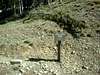
The trailhead starts just north of Eleanor Lake. Eleanor lake is located on the road that leads to the East entrance of Yellowstone. Eyeballing it, it looks to be about 17 to 18 miles east of the Fishing Bridge on that same road. Eleanor lake is clearly marked and can't be missed. The parking lot is just west of the lake and is a popular stopping point for tourist wanting to view the lake. The lot is directly across (south of the road) from a clearly visible sign (north side of the road) denoting the trailhead for Avalanche Peak.
 |  |
Route Description
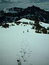
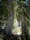
I climbed this route on Saturday, June 05, 2004. The description entails the conditions at the the time of the climb. The trailhead itself begins as an inviting path at around 8300' or so with a clearly visible sign. Upon entering the trail, one soon finds that the path is rather steep and engulfed in forest. The routefinding through this forest is rather difficult granted there is snow on the ground as was the case during my climb. Small metallic orange placards are stapled to a tree here and there to give the general direction of the route but are not placed often enough so do not rely upon these for routefinding. The ascent is generally filled with stepping over felled trees and cutting a path through the woods into a gulley where a creek resides. One could easily take the gulley up if stumbled upon. The key on this route is to continue to head up and be persistent in doing so even in the event of confusion as to where the actual trail is if snow becomes a factor. Sooner or later the sky opens up and the tree line is achieved between the saddle of Avalanche Peak and Cody Peak. Directly to the left (or west) upon reaching this saddle is a small rock karin showing the trail as it heads west up a fairly steep inclination that gains the lower ridge. The saddle itself gives impressive views of a giant snow "Bowl" (if at the right time of year) just to the east of the peak which is visible from the saddle. During snowy conditions, the trail is not visible and one must "kick step" up what I call the "first pitch" of steep snow gaining the lower ridge. Upon obtaining this pinnacle, the route follows a gentle circular motion up and over to the right (North or thereabouts) to gain the peak. The route above treeline is much more distinguishable versus below the treeline. Once on the saddle, one should not have any problems getting to the summit. Its clearly visiblie in proper weather and fairly easy to follow. Overall, you can expect to spend anywhere from 2 to 6 hours rountrip depending on the time of year and the condition of the route as well as your physical condition. The route is rather demanding in snow and at times frustrating through he timberline because of the lack of proper markers and snow covered trail.
 |  |  |  |  |
Essential Gear
For a winter ascent, I recommend gaitors, trekking poles and possibly an ice axe. A rope is probably not necessary. For a summer ascent, assuming the trail is properly bushwhacked below timberline, you probably only need a good pair of hiking boots and the 10 essentials. The route in the Yellowstone newspaper given out at the park entrances is advertised as a 6 hour round-triper. Based on your athletic ability and conditions during the climb, you probably could do it in a much shorter time. I climbed the route on June 5th with snow and left at 9:30 AM and was at the top by 1 PM and back down by 2:30 PM. This is obviously much slower than two hours but the snow slowed us down as well as the trail guessing we were doing going through the timber trying to gain the saddle. A camera is a must on a clear day. The views are extremely impressive! Also, be VERY BEAR AWARE. I am from Houston and not that educated on bears but I did see two sets of some nice size grizzly tracks! Go in a large group and whistle and talk up the entire way. Stay away from bear cubs and if you have the bear pepper spray, bring it! I was armed with a whistle and felt rather nervous after seeing those tracks which paralleled the previous climbers' tracks! Know your surroundings and be smart by exhibiting common sense.