
|
|
Route |
|---|---|
|
|
39.33530°N / 106.1069°W |
|
|
Hiking |
|
|
Spring, Summer, Fall, Winter |
|
|
Half a day |
|
|
Class 1 |
|
|
Approach
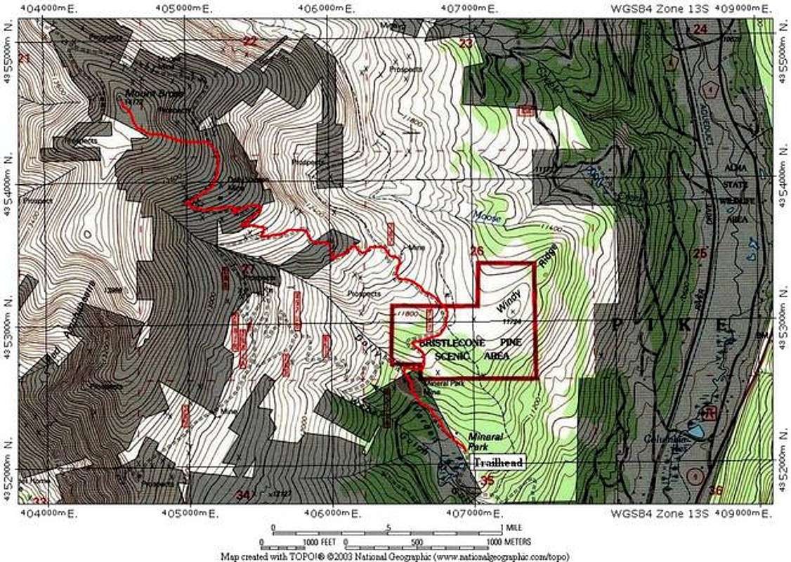
This route begins from the Mineral Park Mine site (inactive), which is also called the Dolly Varden Creek Trailhead. From the town of Alma, just south of Breckenridge ski resort on CO 9, turn onto the Buckskin Road (also called Kite Lake Road or Park County 8) in the center of Alma. Drive the Buckskin Road for 2.8 miles until you see a sign for Windy Ridge Road (Forest Service 415). Take this right turn and follow the Windy Ridge Road for 2.9 miles to an obvious parking area just below the ruins of the Mineral Park mine.This trailhead is at 11,400 feet. You may drive higher on a 4x4 road almost to 13,000 feet if you desire, although I strongly discourage such driving at altitude to preserve the alpine ecosystem.
Winter closure varies on both the Buckskin Road and Windy Ridge road. The Windy ridge road is usually never open until April or May. The Buckskin road is typically plowed to about a mile below the turn for Windy ridge.
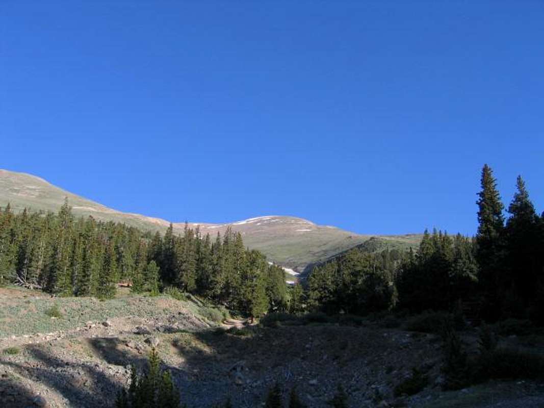
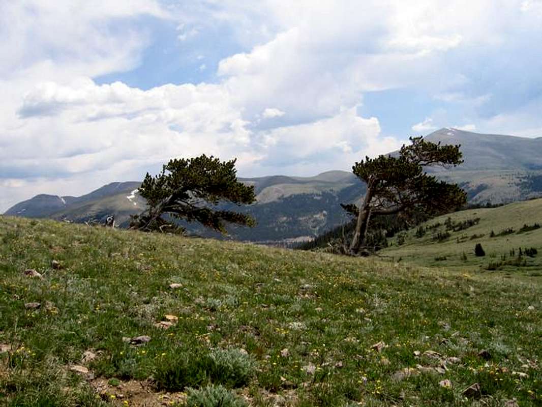
Mount Bross from near the Trailhead at Mineral Park Mine
Route Description
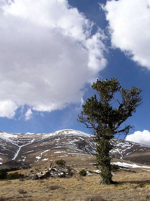
From the Mineral Park Mine, walk up the Windy Ridge road to just above the Mine. The road Ys here - take the right. Follow this road through the Bristlecone Pines (worth a half hour of your time on the way down - see below.)Continue to follow the road as it switches back across this ridge. At approximately 13,200 feet, you will pass the Dolly Varden mine site. Simply leave the road here and head straight for the summit. There is no trail here, but try to stay on rock to avoid trampling the fragile alpine flora.
The summit is quite large and rocky. It will be difficult to determine the actual high point!
Route Stats
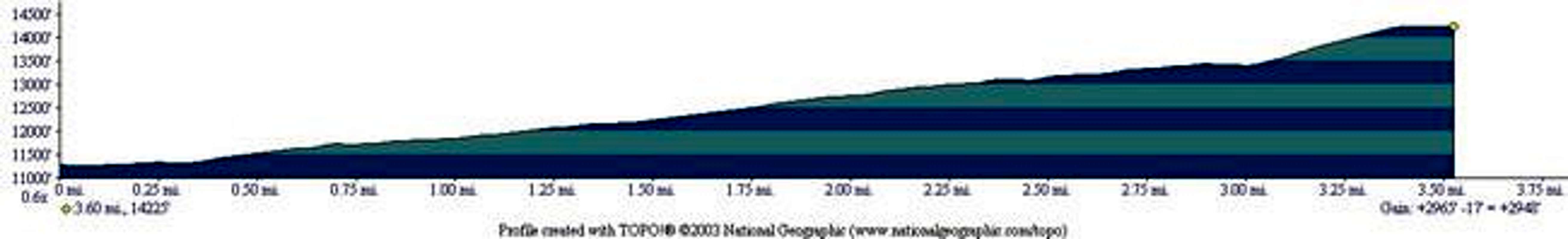
Round Trip Mileage: 7.2 miles
Elevation Gain: 2,965 feet
Essential Gear
No rock gear is needed.For a winter or spring climb, you may need snowshoes or XC skis to get to the trailhead from road closure. It is an easy crampon climb on this ridge, and an easy ski descent. The ridge is often wind-scoured.
Bristlecone Pines
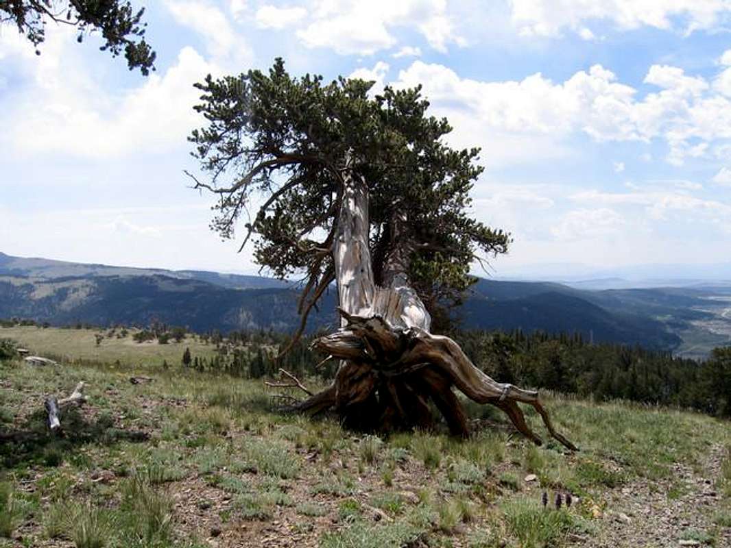
One of the best reasons to climb Bross from this side is the chance to visit the Bristlecone Pines that inhabit this flank of the mountain on Windy Ridge. This is a really amazing area, and is worth a trip alone without climbing the mountain. The National Forest Service has named this area the "Windy Ridge Bristecone Pine Scenic Area."To get here, simply follow the route above for Mount Bross. It's maybe a 15-20 minute hike to the Pines area. It's very accessible.
Bristlecone Pine trees are some of earth's oldest living inhabitants. Some predate the Egyptian pyramids. They only live in six western American states, but the oldest are found in the White Mountains of California.
Bristlecone Pines typically grow in harsh, alpine areas above 10,000 feet. They are able to grow where no other trees can. The trees are multi-trunked, giving the tree the ability to continue to grow after one trunk dies due to fire or a lack of nutrition. The bark of these trees is remarkably hard - they often remain standing long after the entire tree dies.
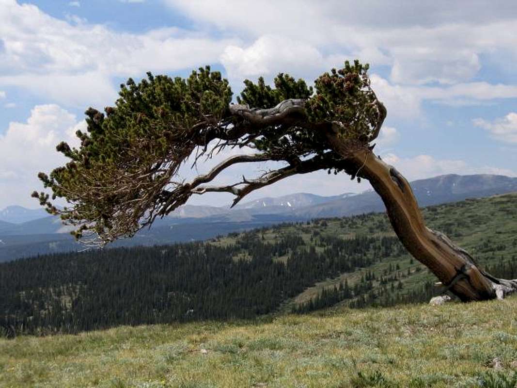
The Bristlecone Pines of the Windy Ridge Scenic Area bend because of the harsh winds in the area, causing the trees to become gnarled and beautiful. It's amazing how the trees have adapted to grow in this harsh area. See photos below. ENSURE THAT YOU TREAD LIGHTLY HERE AND LEAVE NO TRACE!
Methuselah
Methuselah, of the White Mountains of California, is the oldest known tree in the world. It is over 4,700 years old. It was already 300 years old when the first Egyptian pyramid was bulit! Unfortunately, another tree named Prometheus was cut down recently by some scientist. This tree was 4,900 years old. Since this travesty, Methuselah is no longer marked for fear of vandalism.
Read more about these trees at the links below:
The Ancient Bristlecone Pine
Bristlecone Pine
A Song by Roberta Fiester about the Bristlecone Pine
Photos of the Windy Ridge Bristlecone Pine Scenic Area:
A Bristlecone Pine hanging on for dear life on Windy Ridge
Two Pines on the Ridge
In bloom - Photo Courtesy bc44caesar
A photogenic Pine
Red Tape
ACCESS ISSUES:All routes on Mt Lincoln, Mt Bross, and Mt Democrat are on private property.
The Forest Service originally distributed flyers in the area about the routes to all 3 summits being on private property. Kite Lake is public, the Bristlecone Pine area is public, but everything above them is not. The flyers caused millions of phone calls and grief for the Forest Service and the landowners. For instance, Mt Bross has over 50 owners. Mt Democrat and Lincoln don't have that many, but there are still quite a few.
So the Forest Service recently did the press releases that many of us saw in the Dever Post and other news outlets to limit phone calls to the rangers. This is where we currently stand. The land owners are concerned about liability issues, but so far, have not posted or blocked their land. They don't respond to phone calls or emails.
If you call the rangers, they will offer no information on routes and tell you that they are all on private property. This is the official FS stance.
Several organizations, including the Colorado Fourteeners Initiative, are currently trying to work out a plan that works for everyone.
My two cents: Continue to hike and climb here. Respect the land owners and avoid all posted property. Leave No Trace. Pick up trash. Travel in small groups. Give all mining areas a wide berth. Use established trails and roads.
Travel at your own risk.