
|
|
Route |
|---|---|
|
|
44.06850°N / 114.9684°W |
|
|
Trad Climbing |
|
|
Summer, Fall |
|
|
Most of a day |
|
|
5.9 (YDS) |
|
|
III 5.8 - 5.9 |
|
|
III |
|
|
Approach


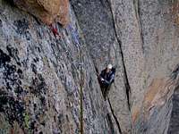
Follow the directions on the main page of Saddleback Peak/Elephants Perch to reach the Saddleback Lakes at the base of Elephants Perch. From the outlet of the lowest Saddleback Lake (first one you encounter on your hike up from Redfish Lake), cross over the stream to the side of the rock face. Hike up avoiding steep slabs to your left. Once near the base of the rock face, traverse left above slabs to reach the start of the climb. I will include photos that try to point out where exactly P1 of this route begins. Generally, you should be looking for a low 5th class gully directly below the unmistakable Diamond (or Cobra Head) formation above.
Route Description


This route is listed on Gary and Lynn Clark North American classic climbs web page. The route is described in Kearney's book as having 8 pitches. We were able to do it in 7 pitches with 60 m rope. This is how I will describe the route here. The route is rated III, 5.9 in both guidebooks (as well as the unpublished topo "floating around"). However Sawtooth Mountain Guides web page rates it at III, 5.8+. This I think is more fair as the "hard" portion is short (15 - 25 feet?) and VERY well protected. Lastly, the August 2004 issue of Rock and Ice rates this route as a 5.8 (no topo there). Anyway you look at the rating, this is a fun-adventure for a 5.8 leader. A seasoned 5.9 leader might find it too passive. Furthermore, we have done the route as shown on the above-mentioned topo. Having read the two climb reports (see Links) included, I think there is some variation as to how you do the route's crux (though what we did seemed to be the most direct and obvious) and consistent with at least one of the TR's listed under Links.
Pitch 1: 5.8, 180+ feet. The pitch starts on a nice low angle ramp (20 feet above ground - good belay spot). Your goal is a small (3-4 foot) tree left of the gully system. Climb up the low 5th class gully (see photo) directly below the Diamond (which itself is several hundred feet above). Some chimneying is involved. About 20-30 feet above an indistinct collection of lodged boulders (or about 90-100 feet above ground) you need to exit left out of the gully via a cruxy mantle move. This is rated at about 5.8 and is pretty much as tricky as things get on this route (IMHO). Good pro at your knee level. This is also the first route finding crux of the climb. It's not that big a deal since if you overshoot up the gully, the downclimb is fairly easy (5.5 - 5.6?). Follow a crack system above the mantle move (another 20-30 feet) to reach a small ledge with the miniature tree on it. You'll probably be out of rope at this point. Belay. See Variation 1 below.
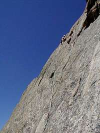
Pitch 2: 5.8, 180 feet. Move up a dihedral (5.6?) for about 20 feet to reach a nice pedestal at the base of a prominent dihedral system (capped by roofs 100 feet above). There's a set of old bolts on this pedestal - see Variation 1. From the pedestal, continue up the dihedral on the right (5.7?) side of the prominent slab (you're heading up for the roofs) until you reach a narrlow ledge that traverses out left onto the slab. Traverse left 15 feet along this ledge to reach a prominent splitter crack running along the center of the slab. Note that the topo we had claims that you can continue up the dihedral via a wide (and widening) 5.7 crack. Did not look fun - splitter in center of face looked much better. Continue up the splitter crack (5.7+ - 5.8) - fun moves with plenty of good rest stances. About 20 feet below the largest of the roofs you will see a set of old belay bolts 5 feet right of the splitter. Belay here on a narrow "hint of a ledge". Might want to supplement the belay anchor with cams.
Pitch 3: 5.8, 160 (?) feet. From belay move back towards the splitter and follow it up towards the roofs. Traverse left under the roofs (5.7) on good face holds. At the left edge of the roofs, move up via a slab (topo claims it's 5.8.....probably easier) to reach low 5th class terrain which then turns into 4th class and eventually reaches a 50-foot 3rd class "V-gully" which terminates at the very base of the Diamond (used the very bottom tip of the diamond as part of the belay anchor). Belay here.
Pitch 4: 5.7 - 5.8. The topo we had claimed 5.8 - I think it was easier than that. From the belay, move up the slabs to your left (that's climber's left of course). Look carefully for pro opportunities as they are not obvious for the first 20 - 30 feet but they are there (even though they might be a bit shakey). The going is pretty easy though (5.6?). You're heading for the arete. About 100 feet above the belay, the line naturally deposits you at the base of a 30-foot dihedral on the right. Climb up the dihedral (with slight overhang at its top) to reach low 5th class terrain above. Belay when you run out of rope (should happen just a bit above the dihedral).
Pitch 5: 5.7, 110 feet (?). This is the second route finding crux of the rotue (IMHO). You are now behind the left edge of the Diamnod. Don't get too innovative - the two cracks on the left (near the arete) though they look appealing from below are actually dead end's (will probably require a hard, unprotected traverse above to return to route if you follow them to their ends) and are quite dirty higher up. Instead, move right towards the edge of the Diamond and follow the easiest line up - small ledges and intermittent cracks on low angle terrain (probably up to 5.7). Belay at the base of a steep, 15-foot finger crack. This is a semi-hanging belay on gear on a slab (small nuts and cams).
Pitch 6: 5.8-5.9, 190 feet. This pitch also has some variations I think. We did it the way it was shown on our topo. Climb up the finger crack above and just right of the belay aiming for wide cracks to the right of a prominent roof above. The finger crack is probably not a 5.9 - you can stem your way up with only one or two mandatory foot jams near the top (maybe). Good rest stance is followed by somewhat awkward climbing in the wide cracks (5.8?) - they "feel" overhung but are not actually. Above, the climbing quickly eases to mid-5th class. Belay when you run out of rope.
Pitch 7: low 5th, 100 feet. Some people might opt to unrope atop P6 above. We did another pitch here of low 5th class climbing. Go up and right. Belay at a point where you feel comfortable unroping. You should now see the west face of the summit pyramid (and realize that you still have a long way to go to top out).
Variation 1: You can do the route in 8 pitches. The brunt of the difference from what I described above would be on P1-P3. Specifically, P1 would end below the above-mentioned mantle move (plenty of good belay opportunities). P2 would end not at the small tree, but rather on the large pedestal with two bolts above the small tree. P3 would take you to the double bolt anchor below the roofs (this is what I called top of P2 above).
Summit Push: If you want to top out on the summit of The Perch, easiest line seems to be from the opposite side rel. to where Moutaineers Route tops out. There was some snow covering the slabs when we were there so we descended a few hundred feet towards the saddle point (heading for Peak 9870'), traversed right (SE?), did some 4th class scramling to reach a boulder field. The boulder field brings you to the class 2 or 3 slabs on the SE side of the summit. Follow this slabby ridge to the top (highest point is obvious - it actually overlooks the point where Mountaineers Route tops out).
Descent: From the summit, return via the same class 2-3 slabby ridge you climbed to reach the summit towards a grassy low point (SE from summit ?). This is the start of the descent gully (mostly 3rd class with one 5th class "step" that is usually rapped). Note that if you're looking at Elephants Perch from Saddleback Lakes, the descent gully is on the right side (east) of the wall and pretty much hugs the base of the wall all the way. Take the gully down and either downclimb the 60-70 foot low 5th class step near the bottom or rap it with one rope. Below the step, either head back to camp (obvious) or traverse back to the start of the route to pick up your stuff (equally obvious and close enough not to be painful).
Escape: The area receives quite a bit of thunderstorm activity in early summer. You might find yourself in a bail off situation. It seems it would be easy to rap the route (two ropes) from top of P1 and P2. It might be tougher to back off from higher up. Will most likely need to leave gear and get innovative with traversing on rappels.
Essential Gear

Mid-sized and small nuts. Cams with stress being on the <1.5 inch range (doubles definitely are nice) and up to 3.5inch units (might want doubles in up to 3"). Helmets.
Route Overlays

