
-
 8862 Hits
-
 72.08% Score
-
 2 Votes
|
|
Route |
|---|---|
|
|
37.95510°N / 105.5337°W |
|
|
Hike |
|
|
Most of a day |
|
|
Class 2 |
|
|
Approach
See the main page for directions to the two-wheel drive (2WD) parking at the beginning of South Colony road. From the 2WD parking lot, hike or drive three miles up South Colony road. The road is signed as a 4-wheel drive road past this point, but a sturdy 2-wheel drive SUV should be able to make it to the trailhead. The road has been improved greatly over the last year and is much better than previous years. After three miles, a Forest Service sign which indicates "Rainbow Trail" will greet you. Parking at the trailhead is minimal, so do not block the road. The trailhead is at 9850 ft. |
Route Description
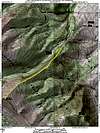
At the sign indicating "Rainbow Trail" go left on a well-established trail. This first part of the trail actually goes northeast which can be a little confusing (see the map below). The trail gently climbs the flanks of the ridge for about 200 yards until reaching the ridge crest. Top the ridge and begin looking for the northeast ridge trail to the right. If you begin to drop down the opposite side of the ridge, you've gone too far.Follow the trail southwest as it winds through the conifer and gradually climbs the northeast ridge. After one mile, the trail reaches Point 10,725 which is indicated by a small cairn. After Point 10,725, the trail immediately descends approximately 200 ft to a saddle. The trail continues to meander through conifer and gets a little fainter as it approaches treeline at 11,800 ft.
From treeline, the trail fades; however, the route is obvious. Head directly up the northeast ridge via alpine tundra, then talus. At least two false summits can be disheartening, but the journey is almost over. Take your mind off the final summit grunt by enjoying the views of Humboldt Peak to the north. The final summit block is rather rough, but easy, and finishes at a huge summit cairn. Finally on the summit, behold the Crestones to the northwest, and other great peaks such as Milwaukee, Broken Hand Peak, and the rest of the Sangres.
Round-trip mileage (Rainbow Trailhead - 4WD): 6.2 miles and 3400 ft. elevation gain.
Round-trip mileage (South Colony Trailhead - 2WD and Winter): 12.2 miles and 4500 ft. elevation gain.
 |