|
|
Route |
|---|---|
|
|
38.62910°N / 109.3173°W |
|
|
Scramble/climb/canyoneering |
|
|
A long day |
|
|
3B-II |
|
|
Approach
Drive along State Highway 128 north from Moab or south from Cisco to the Professor Creek Road between mile markers 18 and 19. The gravel road branches south from the highway and is marked "Ranch Road-Dead End". Drive the Professor Creek Road to its end and park. The gravel road is about two miles long and is good for all vehicles.Route Description
This is a very long day, so get an early start. Crossing the desert in the heat of the day is not pleasent in warm weather. The best plan of action is to cross the desert and climb the mesa in the cool of the morning and then descend the refreshingly wet Professor Creek in the heat of the afternoon.Getting to the base of Adobe Mesa is a maze of drainages and gullies. There are many more than show on the topo map. Much routefinding is required even though you can't get too lost as you can see the objective in front of you the whole way. There are several routes to choose from and the description will be intentionally brief. You must have and know how to use a topo map to follow this route. The route to the summit of the mesa is not too difficult, but it is a bit tedious and strenuous. The climb is well worth the views, however.
From the trailhead, follow Professor Creek. Eventually, you will have to get your feet wet. Carefully follow the map and continue up Professor Creek until you are south of the I+223 mark on the topo map. Climb up to the rim to the south. Notice the ameptheater on Adobe Mesa between Points 6948T and 6995T.
You will head towards the ampitheater using various spurs and drainages to access the drainage draining the ampetheater. The route to the amphitheater is very tedious and more complicated than it looks on the map, and expect to wind around several drainages and spurs. Follow the drainage up the ampetheater; there are many boulders and other obstacles to make the going slow.
The headwall of the ampitheater is steep, but climbable and there are many boulders and trees to skirt. The north facing headwall is covered with a mini pine forest.
Once on the rim, you can walk east and slightly south to the true summit, but the views from there aren't near as impressive as the ones from the points surrounding the rim.
The best choice for spectacular scenery is to follow the rim in either directions and visiting several view points. The views from the various points along the rim are amoung the best in in the world. The western point above Castle Rock may be the very best of all.
The distance to the rim Adobe Mesa from the trailhead is just under six miles, with 2700 feet elevation gain, but it seems longer.
From the summit of Adobe Mesa, descend to the base of the ampitheater. Stay in the drainage until you are west of Point 5105T. Walk east to point 5105T, crossing some minor drainages along the way.
From Point 5105T, head towards 5290T, once again crossing several minor drainages. It is possible to scramble down to Professor Creek not far north of 5290T.
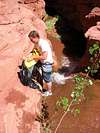
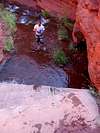
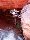
Once at the creek, follow it downstream. Make sure to stop and pack everything in dry bags. There are some reeds and brush at first until the drainage narrows. There is much wading. Eventually, you will reach a bolted rap off a chockstone. If the bolt is missing, a natural anchor can be set up.
Not far below the bolted rap are several natural water-slides you must slide down and into pools. Prepare to get completely soaked!
Make sure to visit Hell Roaring Canyon along the way, which contains a spectacular narrow gorge. Passage is blocked by a huge chockstone, but a really good climber can climb up behind the boulder (assuming the hole behind it doesn't get plugged by flashflood debris) and to the rim. After visiting Hell Roaring, return to Professor Creek and follow it downstream.
The final obstacle, and the crux of the trip is a 30 foot rap through through the waterfall. You will get soaked, and setting up the rap is very tricky. Make sure you learn natural anchors, and please don't leave and slings or bolts that are visible from below. The waterfall is much photographed from below, and a bunch of slings and bolts will mess up the scene for someones photograph of the falls.
The gorge below the waterfall is impressive. From the bottom of the falls, simply follow the creek down to the trailhead. This is a very long trip if you combine the ascent of Adobe Mesa with the descent of Professor Creek, but this is a very unique trip and worth the effort.