Approach
BRING YOUR BIKE and park at the Ribbon Creek parking lot at Kananaskis Village. Bike in on the wide path picking up 500' gain and 5 km. There is a bike rack at the end of this wide trail. Continue on foot for another 6 km (old cabin(s) site 1 km into this hike). You will proceed through the camp site and Ribbon Falls (good photo ops) onto switchbacks. At about 7000' you will be at a drainage opening up to cliffs and water worn rock that lead to a small tairn and the cirque of Bogart. (There are no trails or cairns, I found one flag and started a small cairn in 2003).
Route Description
The cliffs above the drainage contain your first crux. I free climbed 5.6 straight up some of these 20'-30' walls,
but you can circumvent most of them to the top left of the drainage, traversing back over to the right. The top of this problem opens up to a large cirque with the summit of Bogart to the NE. There are no trails, just head straight up the scree staying to the right to bypass a lower cliff. Proceed up hellish scree to the cliffs protecting the summit. Depending on conditions, wind and ice can both be a factor at this point. Look for the driest route. There are quite a few rock bands to face during the last 800'. A steep gully to the left of the bulge in the middle gets you started. I had too much ice and wind to piddle around route finding, so free climbed short and steep rock bands right up the middle. I am sure there is a more moderate route. After this crux, you still have to navigate 3-5 smaller rock-ice bands. Remember your route up, these are steep cliffs. On descent, navigate to the right through the lower crux at 8000'.
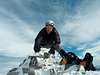
At times, I faced winds of 50-80 mph.
Essential Gear
Ice ax, mini or regular crampons, helmet, goggles for the wind and good legs could be handy.

 4072 Hits
 71.06% Score
 1 Votes