
-
 18722 Hits
-
 74.01% Score
-
 4 Votes
|
|
Route |
|---|---|
|
|
41.83600°N / 123.611°W |
|
|
Hiking |
|
|
Spring, Summer, Fall |
|
|
A long day |
|
|
Class 2-3 |
|
|
Approach
This is the standard approach and route to climb Preston Peak. The trailhead is off of Hwy 199 in northern California. Hwy 199 connects Grants Pass, Oregon and Crescent City, California. The turn off for the trailhead is about 33 miles north of Crescent City or about 48 miles south of Grants Pass. The turnoff is Knopki Creek Road and is numbered 18N07. Knopki Creek Road is about 3.5 miles south of the Siskiyou summit tunnel. Knopki Creek Road immediately turns into a gravel road and it can be driven by 2WD vehicles all the way to the trailhead. About 13 miles from Hwy 199 the road comes to a T intersection. Turn right here and follow this another .7 mile to the parking area at the end. The elevation here is about 5,200 ft. The trail starts on the east side of the parking area.
Route Description
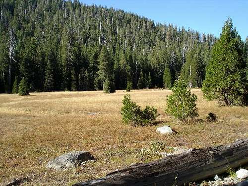
The trail is actually an old roadbed that starts on the east side of the parking area. Climb over the large berms that block motorized travel on the roadbed. This is the boundary for the Siskiyou Wilderness and no motorized traffic is allowed in the wilderness. Follow this road as it gains a few hundred feet and then drops down to Youngs Valley, elevation 4,600 ft. After about 3.5 miles from the TH the road splits. Take the left fork. The right fork goes a short distance to a camping area on Clear Creek below Youngs Valley.
The road bed is rougher now, but it is still a road. You pass a couple of camping areas in a nice old growth forest. The road starts gradually gaining elevation. Pass the trail on the left that heads up to Cyclone Gap and continue straight ahead up to an old chrome mine. At the mine take the left fork up the hill and through the mining area. The elevation of the mine is about 5,200 ft. At the far end of the mining area the road finally ends and you continue on a good trail that goes to Raspberry Lake.

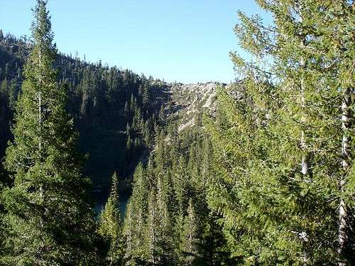
The trail gains a little more elevation before dropping down to Raspberry Lake at elevation 5,004 ft. Preston Peak sits just south of Raspberry Lake and you get a good view of the peak and the route up the north ridge from the trail. You have to descend all the way down to the lake and then climb the ridge on the west side of the lake. Take a break at the lake. It is about 7 miles from the trailhead and it takes about 3 hours to get here.
The trail ends at the lake. From the lake to the summit is a crosscountry scramble that is Class 2 and 3 at times. Follow the north shore of the lake to the west, cross over the lake outlet, pass a couple of camping areas and continue along the shoreline. Soon you run out of trail, but there are “use trails” or game trails that braid the area. Climb up to the ridgeline that is about 300 ft above the lake. There are lots of options here, just pick the best one for you. It is brushy and there is some scree, but eventually you can see the ridgeline and that is you objective. Once on top of the ridgeline you will be able to see up the ridge towards Preston Peak. Preston Peak can be seen peaking out from behind point 6121 on the topo. You still have 2 miles of scrambling to get to the summit.

Follow the ridgeline. There are some “use trails” that tend to disappear. The brush is short and is easy to move through. Use your best judgment for your route. There are cairns along the route, but they are more a confirmation that you are generally on the right track than a definitive track to follow. As you climb, the brush thins out and there is more rock hopping. I tried to stay on top of the ridge as much as possible, but there are obstacles to go around. I traversed around point 6121 on the right side and did not climb over that highpoint. Above 6,500 ft there was a light dusting of snow on the ground from a little storm the day before. It felt like a lot of the “use trails” were on the left side of the ridge. The cairns verified that I was going in the right direction.

Just follow the ridgeline up to the summit. It took me about 2 hours to go from the lake to the summit. The route down is the same as the route you came up. It took me about 5 hours to get to the top and my GPS said it was 8.75 miles from the trailhead. It took me 5 hours to get back to the trailhead from the summit. There is lots of elevation gain on the route back from the lake to the trailhead. I think there is about 4,650 total elevation gain for this hike. Total miles 17.5 and plan on 10 hours of hiking plus breaks.
 |
 |
Essential Gear

Take the 10 essentials always. A GPS may come in handy. The only water is at Raspberry Lake. This is a long dayhike, so be prepared for hydration, nourishment, and blisters.
Miscellaneous Info
If you have information about this route that doesn't pertain to any of the other sections, please add it here.