
-
 4514 Hits
-
 72.08% Score
-
 2 Votes
|
|
Route |
|---|---|
|
|
43.02380°N / 4.7299°W |
|
|
Hiking, Mountaineering, Scrambling |
|
|
A long day |
|
|
Class 3 |
|
|
I |
|
|
Overview
The route of San Glorio is probably the most complete and interesting to reach the summit of Peña Prieta but it's long and a good training is necessary. If you want a shorter itinerary to climb Peña Prieta, see the route Valle de Lechada.Time to summit: 3h 50min (+1h with all the summits and +1h or more in winter conditions)
Slope: 1050 meters.
For the description I will follow the line of summits, but the three first are not indispensables.
Getting There
From Bilbao E-70 (highway) to Castro-Urdiales, Santander, Torrelavega, Cabezón de la Sal, San Vicente de la Barquera. 11km from San Vicente is the crossroad signaled Picos de Europa/Unquera. N-621 to Panes and across the beautifull Desfiladero (Gorge) de la Hermida we arrive to Potes.In the km-122 of the road N-621 between Potes and Riaño is the trailhead: Puerto de San Glorio (1601m).
 |
 |
1.Peña del Portillo de las Yeguas (2108m)
 Peña del P.Yeguas
 Portillo Yeguas
We walk across the track of south side of San Glorio, near of the parking. The first part consist in green hillsides to reach the col under the peak of left side, the Peña del Portillo de las Yeguas, generally know as "Las Tetas" (breasts).
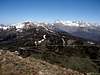
In the upper side before of the col you can see a marvelous view of Picos de Europa in the north and Altos de Cubil de Can and Peña Prieta in the south.
We search in the NW face of the peak the little path with some cairns to reach a narrow pass among the rocks of the ridge. After a little descent we ascent to the evident col called Portillo de las Yeguas (2053m). In this point we can climb to this peak in 10 minutes with a great landscape.
2.Robadoiro (2210m)
 Robadoiro
From Portillo de las Yeguas we can to choose to climb the peak Robadoiro, also know as Alto del Naranco, or the walk in the right side across the hillside west of the mountain. The ramp is important but short to climb the peak but the route is still long. It's an election according with your physical preparation. The view is wonderfull on the summit of the cirque of peña Prieta (as well from the col of Robadoiro). The little peak Faro Robadoiro (2190m, summit east) is only for peakbaggers.
In both cases we reach the Col of Robadoiro (2086m) under the cirque.
3. Altos de Cubil de Can (2448m)
 Altares


Under the cirque the only pass is the climb of the ridge north of Altos de Cubil de Can, also know as Los Altares.
Is the most complicated point of the route, easy without snow with the use of the hands in the exit of upper side. With snow (winter, early in spring) the slope is important and the use of crampons and ice-axe is necessary (the fall is important but generally is not exposed except in the exit).
In the upper side we walk across the four summits of Altares or not (bordering in right side in the hillside), it's voluntary.
-Summits:
First: 2405m.
Second: 2412m.
Third: 2430m.
Fourth and last: 2448m (highest).
Really are secondary summits but the view of the cirque (Pozo de Riofrío) and Peña Prieta is better in the line of the ridge.
4. Mojón Tres Provincias (2496m)
 Tres Provincias and Altos de Cubil de Can
After the descent of the last little peak of Altares we walk easily to reach the last peak of the ridge, the lonely Mojón Tres Provincias, after a hard but short ramp. In the summit we're in the border of provinces of Palencia, Leon and Cantabria with a mailbox.
5.Peña Prieta (2539m)
 Peña Prieta

After the descent of Tres Provincias (be carefull with snow) we reach the narrow col-ridge between Tres Provincias and Peña Prieta. After the walk we reach the begin of a path in the middle of stones (with snow in winter it's not visible) to reach the col between both summits of Peña Prieta. Before the climb of main summit is a good option the ascent of Peña Prieta Sur, also know as Peña del Infierno, the highest point of province of Palencia, and a good observatory over valley of Fuentes Carrionas (this view it's not possible in the main summit). It's an easy and wide ramp.
After the return to the upper col we climb the final ridge of Peña Prieta with the use of the hands (grade I), exposed with snow, easy with dry rock, to reach finally the main summit of Peña Prieta. You can enjoy of the view of full route and a landscape of almost 360º (the summit south impedes the view of a part).
Essential Gear
 Altares ridge
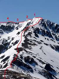 Sketch
Nothing special in summer and fall.
In winter and early in spring are necessary the use of crampons and ice-axe in some parts of the route (Cubil de Can, descent of Tres Provincias, final ridge...)
External Links
- El Correo-P.Prieta: description of route from San Glorio(spanish)